Yellowhammers and Environmentalism: Following Law’s Alabama Brigade to Gettysburg (part five)
This is the latest installment in an occasional series about a journey I took in the summer of 2003 with my friend Joe Loehle. We followed the route of Law’s Alabama Brigade from Raccoon Ford, Virginia, to Gettysburg, Pennsylvania. You can read the first four installments here.
According to authors Penny and Laine of Struggle at the Round Tops, on the morning of Tuesday, June 16, from Little Washington, Virginia the Alabamians moved north. Joe Loehle and I thought the Rebels possibly took Fodderstack Road to out of Little Washington towards Flint Hill, but that was unclear.
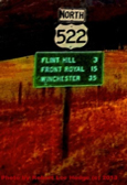
Hood’s division baggage-train apparently moved on the road towards Warrenton (U.S. 522) to Gaines Crossroads (modern-day Massie’s Corner), then turning left, or north, onto the Front Royal Pike. At Massie’s Corner U.S. 522 also turns north to Flint Hill and Front Royal. On this route, Hood’s Division baggage train and artillery, and thousands of others, moved towards Chester Gap, and the Shenandoah Valley.
Law’s men were again moving towards a gap in The Blue Ridge— Chester’s—and the Shenandoah Valley. According to the Penny/Laine map, the Alabamians passed through Flint Hill on the Front Royal Pike, and then ascended to Sandy Hook (modern-day Huntley), covering 10 miles. At Sandy Hook, the Yellowhammers turned right, or north-east, and away from the Shenandoah Valley, marching through the beautiful piedmont region, hugging the east side of The Blue Ridge, towards Barbee’s/Barbar’s Crossroads (modern-day Hume), which was 8 miles away. Between Sandy Hook and Barbee’s Crossroads, Law’s Yellowhammers crossed the headwaters of the Rappahannock River at Rock Ford.
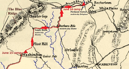
Lee wrote to A.P. Hill on June 16: “Longstreet’s troops have taken the Winchester road as far as Gaines’ Cross-Roads, or some point in that vicinity, where he will turn off to Rocks Ford, across Hedgeman’s River, and thence to Edgeworth and Barbee’s Cross-Roads to Markham. He will then either pursue the route to Paris, or fall down into the Valley by the Manassas Gap road, according to circumstances. This road is said to furnish good grazing and some dry forage, and will tend to deceive the enemy as to your ultimate destination, at least for a time.”
Lee’s letter indicates some of Longstreet’s command may have turned east at Flint Hill and used the Salem Road (modern-day Crest Hill Road/County Route 647) to get to the little-known cross-roads of Edgemont, then turning left, or north, marching 4 miles to Barbee’s Cross-Roads (Hume). This conjecture is an illustration of some instances where more detailed research is needed.
In this area of our journey Joe and I were confused as to what roads the Alabamians could have used when turning right in the Sandy Hook/Huntley area. The road network we thought had been altered; in some cases the old roads would dead end. We were lost for a spell. Eventually back on track, we made it to Barbee’s Crossroads/Hume, where we turned left, or north, onto the modern-day Leeds Manor Road. Markham Station was about 5 miles north on the Manassas Gap Railroad line.
According to Penny and Laine’s book Law’s men marched to the Markham Station area, where the Yellowhammers bivouacked on the evening of Tuesday, June 16th. However, the Penny/Laine map showed the Alabamians camping at Piedmont Station (modern-day Delaplane)—five miles east of Markham. The sequence of places will be debated, but the map’s location made more sense — to arrive in Markham first, then moving east to Piedmont Station. Additionally, Hood’s 7,400-man division, and perhaps other elements of Longstreet’s Corps, were obviously strung-out all over the road, conceivably all the way from Markham to Piedmont Station.
A Rebel said of the majestic splendor and agriculture around Markham, “The whole region is incomparably beautiful. From the tall hills, waving in grain and grass and clover, the view is enchanting. The beauty of the deep shady dells and green hills is heightened by the rugged spurs of the Bull Run Mountains on one side, and the towering grandeur of the Blue Ridge on the other.” Thankfully, one can still get that feeling today.
Law’s Yellowhammers then advanced east, by-way-of modern-day Virginia Route 55 (The John Marshall Highway) to Piedmont Station (modern-day Delaplane) – 5 ½ miles away.
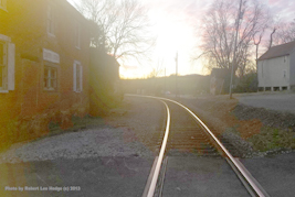
Piedmont Station reminded some of the veterans of the 4th Alabama that they had entrained two years earlier on locomotives at the rail-stop for their first fight at Manassas; it was one of the early examples of moving troops by the newer technology of “high-speed” rail. Piedmont Station/Delaplane is yet another true Virginia treasure, being very evocative of the past.

A Confederate wrote of his experience in The Blue Ridge area, “We are in the western portion of Fauquier County. For those who love a broken, mountainous country, wild, picturesque scenery, the country passed through to-day has its charms. Often the soldier, rising a hill, carpeted with the beautiful clover in full bloom, suddenly comes upon a farmer’s snug, comfortable residence, built in the deep, shady dell, as though he sought a hermits life. His copious barns and numerous outhouses; the dark shady path leading to a cool spring, and a stone spring house, well filled with jars of milk and butter; and fat cows and horses, browsing on the hill sides—these all speak eloquently of the comfort and ease enjoyed by the Virginia farmer.”
It is interesting to read from multitudes of soldiers about their appreciation for the beauty of the landscape; it is a common theme. The accounts from many soldiers excessively praise the environment they marched through somewhat, perhaps, in a spiritual-Christian sense of stewardship, mixed with the Jeffersonian vision of the yeoman farmer. That idea again triggers a thought about future environmental efforts: Could left-leaning environmental movements attract to their causes more right-leaning conservatives of a more profound religious bend? After all, conservation is stewardship.
An enjoyable tale of Mr. Hodges’ travels.