Waud’s Sketches of Banks’ Ford
ECW welcomes back guest author Eric Atkisson.
During his time covering the Civil War for Harper’s Weekly, Alfred R. Waud sketched several scenes from the north side of the Rappahannock River near Banks’ Ford. Today, the spots where he sat to do those sketches can all be found on a conservation easement “allowing for low-impact recreational use”[1] but walled off by miles of private property in Stafford County, making the river the only way most of the public can currently access it. This is possible to do on foot at several points, if not easy or advisable for everyone, and only when the river hasn’t risen. Kayaking from the Motts Run Boat Launch in Spotsylvania County is also an option.
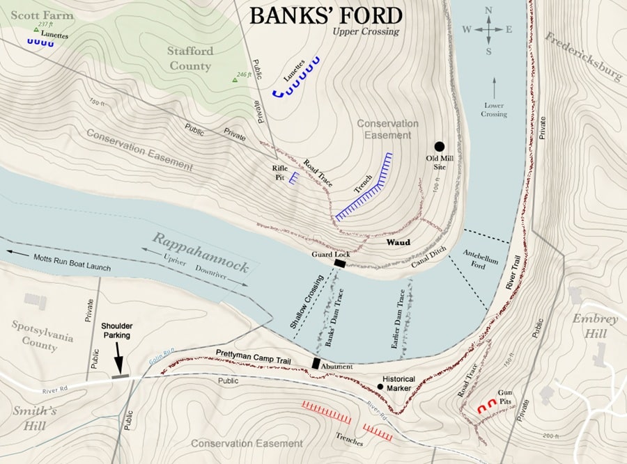
Just west of what is now I-95, Banks’ Ford was critical to Union Army plans in early 1863. For Ambrose Burnside it offered a way to potentially outflank Lee’s army after the Battle of Fredericksburg, and for his successor, Joe Hooker, it was a means of greatly shortening his lines of supply and communication from Falmouth to Chancellorsville. Encompassing not one but two antebellum fords, the more accessible of the two today is near the southern tip of the riverbend around Banks’ Ford. From River Road, the Prettyman Camp Trail leads to the stone abutment of Banks’ Dam, built in the late 1840s as part of an ambitious effort to make the Rappahannock between Carter’s Run[2] and Fredericksburg navigable to commercial flatboats. When the river is low, one can cross it just above the old dam trace, taking care to step around rocks and deeper furrows in the riverbed. On the other side are the remains of the dam’s guard lock, where Banks’ Canal began. From there it’s best to turn right and follow the riverbank downriver until it smooths out near the site of the historic upper ford. An old road trace can be found uphill, across the canal ditch.[3] A short distance up that road it’s possible to turn around and, squinting through the trees, see much of the same view that Waud sketched in early 1863, when the fords were picketed by both armies.
Back on the south side of the river, a sign featuring Waud’s sketch faces this location. Placed by the Friends of the Rappahannock, Fraternizing at the Ford is the only historical marker of any kind to be found on the battlefield today. From there what becomes the River Trail soon bends north, passing beneath a long Rebel gun pit facing the Federal ones on the opposite heights and, less than a half mile downriver, a long Rebel trench paralleling a ridgeline portion of the Owl Loop Trail.
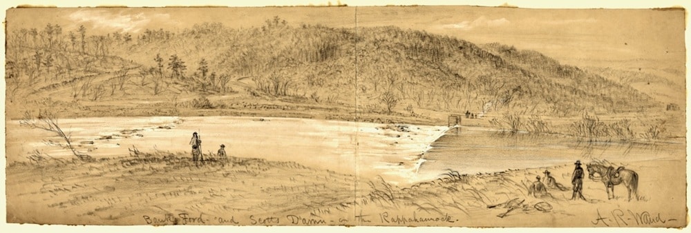
Ahead and across a stream, the modern trail follows an old antebellum road that once led to a “blind ford” connecting to Stafford County. Sometimes known as Scott’s Ford, this in fact is the Banks’ Ford repeatedly referred to in official reports and communications during the war, not the upper crossing near the dam. In early 1863, Waud sketched this view from a spot near Scott’s Mill:[4]
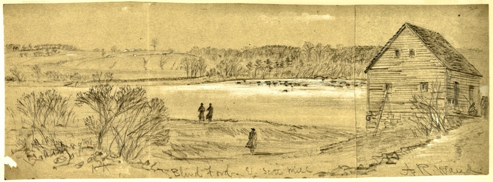
Visible along the far riverbank is the same antebellum road part of the Owl Loop and a portion of the Beach Trail follow today, through the wooded ravine to the right and ending at a point left of the soldiers, where a ferry service operated before the war. In the early hours of May 5, 1863, weary VI Corps soldiers marched down that road after their repulse at Salem Church. Half of them crossed on a pontoon bridge laid May 3 at the site of the ferry, while the other half veered north across those visible flats toward a second pontoon bridge laid May 4 “under a severe fire of shot and shell” from Rebel artillery.[5]
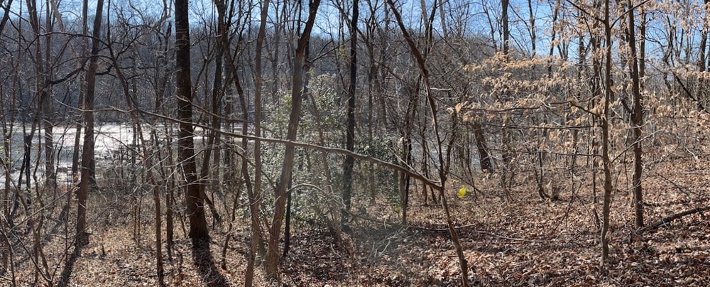
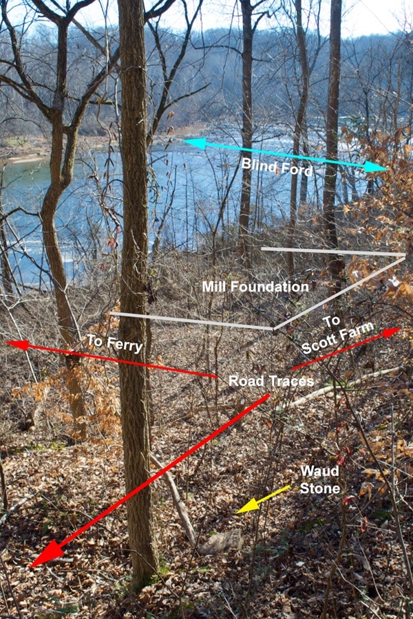
Left of the rocks in Waud’s sketch is the “blind ford”[6] where the river is narrower, shallower, and easier to cross than around Banks’ Dam, especially along the ford’s northern edge just before the sandier, deeper portion of the river where the ferry service ran. An antebellum road trace still wraps around the west and north side of the mill’s surviving foundation, ending at the river where the ferry began. It was on this road, just above where it bends toward the river, that Waud did his sketch. At the exact spot where the view today most aligns with the reference points in the sketch, there is a small, flat-topped boulder where he must have sat:
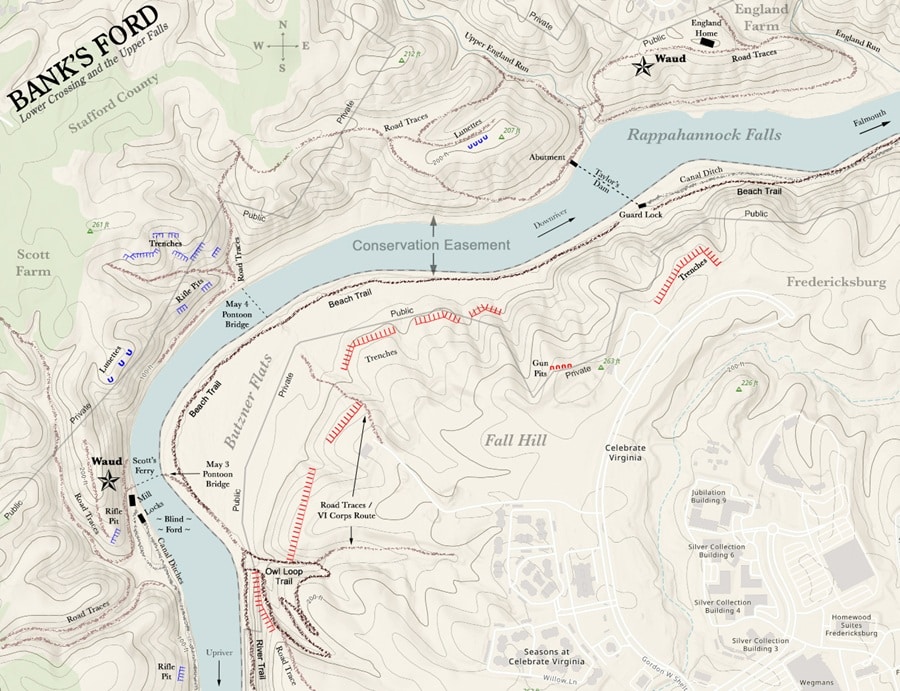
Further down the Beach Trail, near the southern guard lock of Taylor’s Dam, the river is even shallower and possible to cross on foot in several places between the lock and the I-95 bridge.
A series of trails exists on the easement north of the river, but the trailheads are all on Celebrate Virginia HOA property reserved for private use. One of the trails follows antebellum road traces around a hilltop between England Run and Upper England Run, where the home of Basil England stood during the Civil War. On a spur just west of the home and east of the road trace, Waud sketched this scene looking southwest toward Banks’ Ford, with Taylor’s Dam in the foreground:
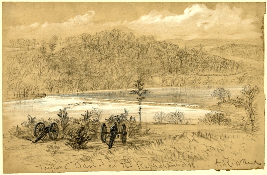
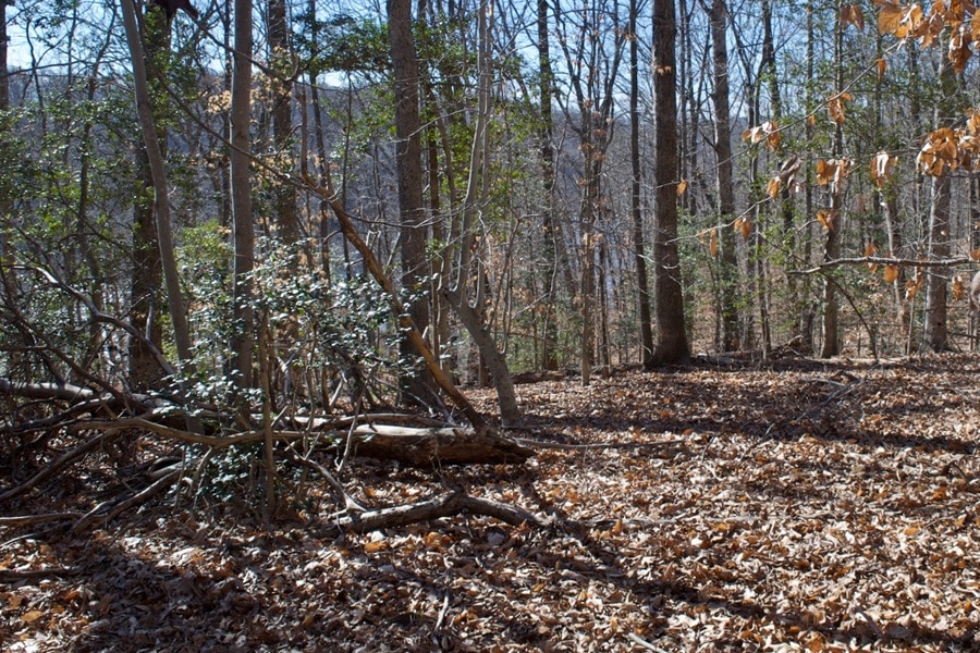
While trees again block the view, the distant hilltops best align with Waud’s sketch in this immediate vicinity. The two cannons were somewhere near that fallen tree on the left, and the patch of rocks and white water barely visible above it matches what Waud drew.
These historic sites and vistas might someday be more accessible, without the need for crossing the river. Stafford County has acknowledged that places along the easement “could be used for hiking trails” and has suggested the possibility of a Rappahannock Scenic River Trail connecting to “existing pedestrian trails in the Celebrate Virginia North development” and a “Cannon Ridge Trail” around Banks’ Ford.[7]
Others have gone further, proposing the creation of a county or regional park on the site of the old golf course.[8] Meanwhile, studies are underway for a road extension and bridge that would cut across the middle of the battlefield, most likely near the lower ford.[9] But all of these possibilities are years away from becoming a reality, if at all. For now, the northern half of the Banks’ Ford battlefield remains a lost world known only to a few, and most memorably through the wartime sketches of Alfred R. Waud.
————
Eric Atkisson has a B.A. in History from Ripon College and a M.F.A. in Creative Writing from George Mason University. A retired Army National Guard officer and veteran of the Persian Gulf and Iraq wars, he recently started the Friends of Banks’ Ford Battlefield and volunteers for the National Park Service, Friends of Wilderness Battlefield, and Cedar Mountain Battlefield Foundation.
Endnotes:
[1] “River Conservation Land,” City of Fredericksburg, VA, accessed February 6, 2026.
[2] At Waterloo, in Fauquier County.
[3] The road pre-dated the Rappahannock Navigation. When the canal was dug it blocked the road’s final descent to the ford.
[4] Starting in the 1850s, the Banks and Scott names were often used interchangeably to describe various features of the area, including the dam and the lower ford. Hugh Scott owned the old Banks farm on the heights above the fords, while his brother Dr. William S. Scott owned the old Banks mill.
[5] “Newspaper Clippings,” New York State Military Museum and Veterans Research Center, accessed February 6, 2026.
[6] Meaning submerged and more difficult to see, due to the effects of Taylor’s Dam downriver.
[7] “Bicycle & Pedestrian Facilities Plan,” June 4, 2019, Stafford County, VA, pages 3-10 and 4-2. “Comprehensive Plan 2016-2036 (2021 5-Year Update),” Stafford County, VA, page 4-7.
[8] Former Stafford County Supervisor Joe Brito is petitioning to establish a “Regional Events Historic Park” on the site of the old golf course.
[9] “River Crossing Parkway Alternatives Study,” Fredericksburg Area Metropolitan Planning Organization (FAMPO), November 2025. Option C, which would run near the lower ford and potentially include a pedestrian bridge beneath it, is the one currently receiving the closest attention and study.
Great work, Eric! It’s great to see this historically important site get some of the attention it so richly deserves.
I agree!
Thank you, both! Much appreciated, and it was an honor to have another blog published. 🙂
Very interesting and well done. Thank you for this study.
Thanks, Kevin!