Crossing the Osage
ECW welcomes back guest author William M. Koch.
“Get all your forces together so as to sustain yourself and if you cannot join me hang on [Missouri Gov. Claiborne Fox] Jackson’s flank or rear if he advances to meet me. I have to cross both this and the Grand River which is 20 miles back and where my trains are still crossing by means of ferrying which is a very slow process.” So wrote Brig. Gen. Nathaniel Lyon to Col. Franz Sigel after learning of Sigel’s defeat at Carthage, MO, in a letter written on July 10, 1861, from Huffman’s Crossing of the Osage River.[1]
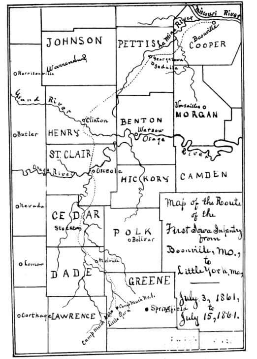
Lyon routed Gov. Jackson’s Missouri State Guard at Boonville on the Missouri River on June 17, 1861, after which Jackson and the guardsmen fell back to southwest Missouri. Delayed by bad weather, Lyon did not leave Boonville until July 3, but he reached the crossing of the Grand River near Clinton, about 100 miles from Boonville, on July 7.[2]
Lyon was joined here by the command of Maj. Samuel D. Sturgis. The crossing of the Grand was difficult due to the river being in flood stage, and the army had to cross using an improvised ferryboat. Another bad crossing awaited at the flood-swollen Osage in the Osceola area.[3]
The Osage was narrower than the Grand, but had a faster current. Here, the ferryboat was captured intact by a cavalry detachment on the morning of July 8, which was surely an encouraging sign. Lyon’s infantry reached the crossing site the following day.[4]
Wilkie wrote that, due to the larger ferryboat available on the Osage, “the crossing proceeded in consequence with greater rapidity;” his description of the crossing suggests a fairly orderly process with the exception of the ferryboat twice slipping its ropes.[7]
Ware tells a somewhat different story, perhaps more fitting to green troops trying to cross a flooded river. Not only did the road to the ferry site need improvement (Wilkie does note that the wagons had difficulty crossing because the “banks of the river are very steep and high”), but a number of losses were sustained during the crossing. One man was killed in a logging accident, four succumbed to sunstroke or heatstroke, another was the victim of an accidental shooting, and yet another was fatally run over by a wagon. There were two drownings which Ware interpreted as suicides, and two men went missing.[8]
Lyon pushed his troops hard after the crossing (at one point, the men marched 50 miles in 30 hours) and the troops reached the Springfield area on July 13, although Lyon did not permit the worn-out soldiers to enter the town when they first arrived for fear that they would plunder it.[9] On August 10, one month to the day after Lyon’s letter to Sigel, the Union general attacked a mixed Confederate and Missouri State Guard camp along the banks of Wilson’s Creek, where Lyon was killed and his army defeated.
Can more information be found about the location of the crossing itself? Ware identified the ferry site as “near Osceola,” but noted that the march south from the river did not bring them into the town itself. A hand-drawn map included in Ware’s published reminisces shows Lyon’s column crossing the Osage between Osceola and the mouth of the Sac River, and Ware also mentions that the men marched on the east side of the Sac on July 11.[10]
Wilkie, in a letter dated July 15, 1861, located the crossing at Hoffman’s Ferry, twelve miles west of Osceola, and “in the midst of a dense wood, without a house nearer than two miles in either direction.”[11] Wilkie appears to have exaggerated the isolation of the crossing (the ferry keeper had to live somewhere nearby), especially since Ware mentions that the men, soon after beginning the march on July 11, encountered a village containing a few homes, a store, and a blacksmith’s shop.[12] As an additional piece of evidence, Lyon’s letter to Sigel stated that it was written at “Huffman’s Crossing of Osage River just above [i.e., upstream or west of] mouth of Sack [sic] River.”[13]
Huffman’s (also spelled Hoffman’s) Ferry was an Osage River crossing near the community of Roscoe. Founded in the late 1830s, Roscoe was originally located on the river before being moved slightly south. The town was not platted until after the Civil War.[14] This provides a concrete location for Hoffman’s Ferry/Huffman’s Crossing as mentioned by Wilkie and Lyon, and the small community of Roscoe just south of the river crossing is consistent with Ware’s recollection of marching through a village early on July 11.
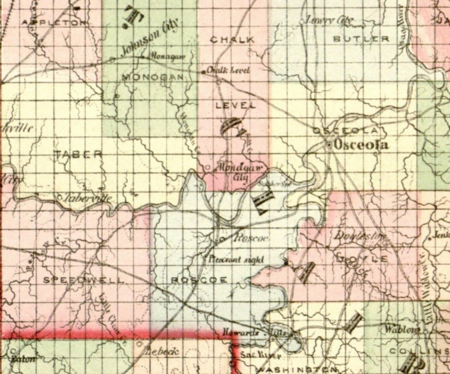
Wilkie states that about a mile from the camp on the south side of the Osage, Lyon’s column encountered “a small grocery store and post-office,” whose postmaster was named R. W. Bolles or Balles.[15] An 1861 listing of postmasters in Missouri lists Ralph C. Bowles (Wilkie’s “Bolles” is presumably a phonetic attempt at this name) as the postmaster of the Pleasant Site post office in St. Clair County.[16] The Pleasant Site post office is rather obscure, but an 1873 map shows a location named “Pleasant Sight” just to the southwest of Roscoe, and west of the Sac. Importantly, it does not show any crossings of the Osage between Roscoe (the crossing here must be Hoffman’s Ferry) and Osceola.[17]
The present author finds the evidence convincing that Lyon and Wilkie’s identification of the crossing site with Hoffman’s/Huffman’s Ferry is correct, and that Pvt. Ware erred in placing the crossing east of the Sac. The details of Wilkie’s account are consistent with a crossing location near Roscoe, particularly the placement of Bolles/Bowles’ post office within a mile of the start of the march on July 11. Additionally, the location of the crossing as being twelve miles west of Osceola is more consistent with a crossing near Roscoe than one east of the Sac.
With this location pinned down, it next follows to see what still remains of the crossing site. A 1903 plat map shows the crossing slightly west of the trough of the bend in the Osage, at land owned by Lucy Brown. This is the name of the wife of George F. Brown, who took over operation of Hoffman’s Ferry in 1881.[18] As late as 1940, the river crossing was still located in this area, although the highway bridge was relocated downstream sometime before 1984.[19]
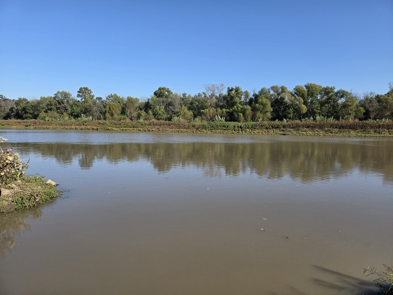
The historic crossing site is within a few hundred yards of the current public river access at the Roscoe boat ramp, although the appearance of the area has been modified due to the damming of the Osage at Warsaw in the second half of the 20th century. Commemoration of the site may not be feasible, due to the continuing tendency of the Osage to flood – a sign affixed well up a light pole shows the high water mark from a flood in 1986.
William M. Koch is a certified public accountant who resides in southwestern Missouri.
Endnotes:
[1] Nathaniel Lyon to Franz Sigel, July 10, 1861. https://digital.shsmo.org/digital/collection/amcw/id/28671/rec/1 (Accessed October 8, 2026)
[2] Frank J. Welcher. The Union Army, 1861-1865: Organization and Operations. Volume II: The Western Theater (Bloomington, IN: Indiana University Press, 1993), 679-681.
[3] William Riley Brooksher. Bloody Hill: The Civil War Battle of Wilson’s Creek (Omaha, NE: Potomac Books, 2000), 128-129.
[4] Franc B. Wilkie. The Iowa First. Letters from the War (Dubuque, IA: Herald Book and Job Establishment, 1861), 80-81; Eugene F. Ware. The Lyon Campaign in Missouri, Being a History of the First Iowa Infantry (Topeka, KS: Crane & Company, 1907), 183-186.
[5] Brooksher, 128-129; Welcher, 679-680.
[6] Wilkie, 81; Ware, 183-184.
[7] Wilkie, 80-81.
[8] Ware, 186-187; Wilkie, 81.
[9] Brooksher, 129-130; Edwin C. Bearss. The Battle of Wilson’s Creek (Diamond, MO: George Washington Carver Birthplace District Association, 1975), 1.
[10] Ware, 186, map following 200.
[11] Wilkie, 80-81.
[12] Ware, 192.
[13] Lyon to Sigel, July 10, 1861.
[14] Bill Earngey. Missouri’s Roadsides: The Traveler’s Companion (Columbia, MO: University of Missouri Press, 1995), 223.
[15] Wilkie, 81-82.
[16] Register of Officers and Agents, Civil, Military, and Naval, in the Service of the United States, on the Thirtieth September 1861 (Washington, D.C.: Government Printing Office, 1862), *286.
[17] R. A. Campbell. Campbell’s New Atlas of Missouri (St. Louis, MO: R. A. Campbell, 1873), map 25.
[18] Standard Atlas of Saint Clair County, Missouri (Chicago, IL: Geo. A. Ogle & Co., 1903), 31); The History of Henry and St. Clair Counties, Missouri Containing a History of These Counties, Their Cities, Towns, Etc., Etc. (St. Joseph, MO: National Historical Company, 1883), 1200.
[19] Glenn S. Smith. Roscoe Quadrangle. Map. (Washington, D.C.: United States Department of the Interior Geological Survey, 1938); Bolivar, Missouri. Map. (Reston, VA: United States Geological Survey, 1984).


Good detective work.