Exploring Jericho Mills
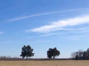
It feels more like late March than late January as we walk across the field at Jericho Mills. The sky is as open and clear as the ground we’re walking across. Dried cow patties dot the field like landmines, and barbed wire runs along the field’s edges. It could just as easily be a World War I battlefield as one from the Civil War.
But we are along the North Anna River in central Virginia, not in Europe. Sam Smith from the Civil War Trust is showing us around the ground. At 665 acres, it’s one of the largest land acquisition the Trust has ever targeted. The $3.14-million price tag might seem a hefty sum for a piece of land associated with the most overlooked and least understood phase of Ulysses S. Grant’s 1864 Overland Campaign—but walking the ground, it’s easy to see this was money well spent.
“This was too important to pass up,” Jim Campi, the number-two guy at the Trust, told me last spring when they announced the fund-raising effort. “We had the chance to essentially preserve an entire battlefield. That doesn’t happen very often.”
After maneuvering their way out of Spotsylvania beginning on the night of May 20, the two armies found themselves along the banks of the North Anna River, where action opened May 23 at Jericho Mills. Robert E. Lee had expected Grant to attack much farther east, so the crossing caught him entirely by surprise. Lee effectively countered–eventually establishing one of his most clever defensive positions of the war–but the battle at Jericho Mills revealed the diminished effectiveness of the Army of Northern Virginia.
Jericho Mills is especially interesting to me for reasons generally overlooked in most scholarship. As I walk across the field, the World War I comparison is easy to make. The defensive warfare that evolved over the course of the Overland Campaign and into Petersburg–the trenches and the field fortifications–are precursors to what unfolded in Europe some 50+ years later. It is a comparison we often make when talking about the Overland Campaign as we take visitors across the battlefields. Lee’s eventual “inverted-V” position at North Anna serves as a wonderful example.
But Jericho Mills is so interesting to me because, rather than a forecast of things to come, it is a throwback to an earlier part of the war. Here, both armies moved out across open ground and slugged it out with each other–something that doesn’t really happen elsewhere during Overland Campaign. There were many open field attacks, but they usually involve Federals assaulting Confederate defenses. The fight at Spotsylvania’s Harris Farm, just four days earlier on May 19, serves as another example, but there aren’t many others.

The field here at Jericho Mills is generally flat, with a few swells that quickly turn into deep ravines the closer they get to the river. The terrain in some places is so steep that Federal engineers had to cut their own road up from the Jericho Mills ford because wagons traveling the regular road could not make the grade.
Some of the Confederates got trapped in one of those swells and took withering artillery fire, which shifted the battle’s momentum, turning a Federal rout into a tenuous victory. Nightfall allowed Federals to consolidate their position.
As we hike around, we find the artillery positions. Six cannons had been hauled into place in the heat of battle, with no time to fortify, but afterwards, they threw up earthworks to better protect their position. Those works still look impressive. We also find the site of the former Fontaine house, now gone. Aside from the depression where the basement had been, nothing remains beyond the leftover detritus of old archaeological work, including a long-abandoned outhouse built by the some archeology students.
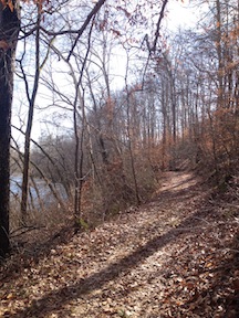
A farm lane leads from the back corner of the field down to the river. Past the steep drop, there is a narrow lip of flat ground along the very edge of the river. A path winds along, taking us to the former mill site. On some days, the river is low enough that an adventurous battlefielder can still ford it, but recent snowmelt raised the water and chilled it, too. That’s an adventure for a warmer day.
Sam proves great fun to battlefield with. He eagerly pounds into the brush with us as we explore the landscape, bushwhacking through the forest on the far edge of the field and clambering up and down ravines. He walks the open ground head-high, like a sun-worshipper, then checks his maps with a birdlike-quick dip of his head.
Together we puzzle together the accounts, the maps, and the landscape to better understand the battle. This is why preservation efforts are so crucially important. Nothing beats boots on the ground.
Finishing up work on Strike Them a Blow: Battles Along the North Anna River, I’ve found this to be especially invaluable. We’re privileged that the Trust has offered us access to the Jericho Mills battlefield today. Eventually, the land will fall under the purview of Richmond National Battlefield. With Hanover County’s North Anna Battlefield Park just a couple miles down the road at the apex of Lee’s eventual inverted-V line, visitors will be able to get a clearer picture of this murkiest phase of the campaign.

While 665 acres is a substantial preservation victory and money well spent, it was not the largest land acquisition the Trust has ever targeted. Before the CWT (or even the CWPT) existed, a coalition preservation minded individuals persuaded a private land trust with a national base called the Association for the Preservation of Civil War Sites to purchase over 700 acres of threatened battlefield in the early 1990’s. The successor organization to the APCWS, called the Civil War Preservation Trust has added to the preserved acreage. Today over 1000 acres are saved at Brandy Station. Land that easily could have been an industrial park or a Formula One Race Track (incredible, but true).
More recently, in 2013, the CWT purchased 964 acres of the Kelly’s Ford battlefield. This land saw the majority of the March 17, 1863 afternoon fighting and the view-shed today is amazing. Wayside markers tell the story of Kelly’s Ford and the Chancellorsville Campaign. The markers are Newby Shop Road. The site was fittingly dedicated on March 17, 2013, 150 years to the day of the Battle of Kelly’s Ford. This land was also played a part of the First and Second Battles of Rappahannock Station, the June 1863 Brandy Station, and the Federal Winter Encampment of 1863-64. Truly hollowed ground.
Thank you Chris for this interesting narrative & your interest in preserving this history. It is now more than 5 years since your post but the reading is now fresh for me. The site of Jericho Mills has long been a source of keen interest for me, especially while driving on I-95, through Virginia. Does anything remain of the mills that Alexander Gardner once photographed? Can the public now walk the ground where the photo of Don Pfanz, Sam Smith, Dan Davis & Ryan Quint appear?
I, too, am wondering about accessibility to the area of Quarles Mill and the Jericho Mills battle site now in 2022. I would pay a guide to take me there.
May 14, 2026
I would like to know, Just Where is the ground that the US. Regulars fought on
Starting from the Entry sign Jericho Mill park & Trail crossing the train tracks & road? The River would be my Final destination, before we return to leave the Park.