Exploring Totopotomoy
The first time I visit the Totopotomoy Creek Battlefield at Rural Plains, it’s an unseasonably mild day in late winter. I’m taking pictures for the upcoming Emerging Civil War Series book No Turning Back, so I can’t stay long because I have the entire Overland Campaign to photograph. But I plan to come back for more pictures once things have greened up just a tad, and I’ll set aside a couple hours to explore.
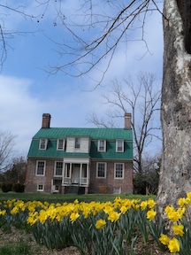
When I do, it’s unseasonably bitter—low teens. The daffodils look like bright yellow popsicles. Someone froze tiny bits of the sun solid and popped them onto green sticks and stuck them in the ground. That sounds perhaps a lot more quaint than I want it to for being as damn cold as it is.
“Totopotomoy” has eluded me for years, and I’ve decided that the cold temps are the battlefield’s way of exacting its revenge on me.
When I say it has eluded me, I mean that on almost all levels. I’ve not been able to spell it for the life of me—which, as a writer, makes it a bigger issue than it might be for most people. As a Civil War writer who spends a lot of time on the Overland Campaign, it’s even more of a problem. It makes me long for something easier to spell, like “Chickamauga.”
I’ve never been able to pronounce “Totopotomoy,” either. Working at Spotsylvania, I often refer to Totopotomoy as one of the next steps in the Overland Campaign—yet it’s always proven to be a tongue-twister. “Top-o-pop-o-mee.” No, that’s not right. “Top-on-top-o-mee?” No, too Irish. “Tot-o-pop-o-mee?” No, no, no.
Say it with me slow: “Tot-o-POT-o-mee.” Never mind that the last syllable is spelled “MOY”—it’s pronounced “mee.”
It doesn’t help that a state historical sign along the roadside also refers to “Totopotomoi,” a chief of the Pamunkey tribe. Totopotomoi was a British ally killed at the Battle of Bloody Run in 1656—one of the bloodiest Native American battles in Virginia history. Or so I find out later when I do a little research.
It’s one of three layers of history—and the earliest one—overlaid atop this property. Then comes its Revolution-era history. Rural Plains, the home that sits on the grounds, belonged to the family of Sarah Shelton. In 1754, Sarah married Virginia politician Patrick Henry the home’s front parlor. The man who later said “Give me liberty or give me death” was happy to tie himself down.
Then there’s the Civil War history, which rolled in on May 29, 1864. That’s eluded me, too. People are generally so anxious to get to the big ugly fight at Cold Harbor that they skip right over Totopotomoy, which is only a couple miles away and a couple days earlier. I often cite the North Anna River as the forgotten stage of the Overland Campaign, but if I’m honest, Totopotomoy Creek gets the shaft even worse.
Well, it would get the shaft if people knew about it, that is—but generally they don’t. It’s more like oblivious ignorance than willful neglect. The larger narrative of the Overland Campaign goes Wilderness—>Spotsylvania Court House—>North Anna River—>Cold Harbor. Totopotomoy Creek eludes almost everyone.
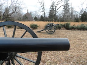
 Richmond National Battlefield has 124 acres of the original Rural Plains property preserved, offering a fairly representational perspective of the Federal position at Totopotomoy. I come here on this most frigid of days to walk the ground with my buddy Phill Greenwalt. Phill and Dan Davis have just finished work on their book Hurricane from the Heavens: The Battle of Cold Harbor (which has since been released and is now available!). Editing Dan and Phill’s book has given me an excellent understanding of events at Totopotomoy Creek and how they essentially dovetailed first into the battle around Bethesda Church and then down toward the Cold Harbor crossroads.
Phill and I walk the trail, both of us pretending that we’re not as cold as we really are. The sun is out, and the day is daffodil-bright, but damn, it’s cold.
The trail, a two-mile loop, leads us past the Shelton House and some dilapidated outbuildings before curling around past some Federal earthworks. The area along the path is wild, but a patch around the earthworks has been cleared so that the neatly-trimmed humps of dirt stand out starkly. In this area, parts of the II Corps hunkered down after lead elements encountered “a strong force of the enemy . . . behind [e]ntrenchments of a formidable character.”
 The path continues on past an old family cemetery. Headstones jut at impossible angles out of the earth, like the nubs of crooked old teeth.
Farther down, past a pair of freshly tilled fields, the path runs into the woods and across a cleared right-of-way for massive powerlines. The last time I saw power towers so large, they were strung around Tokyo to keep Godzilla out.
The Park Service’s path terminates at the north back of Totopotomoy Creek itself, but a wooden footbridge crosses the waterway. The creek itself doesn’t seem too wide or deep, but spring rains haven’t swollen it yet, either. What makes it particularly unappealing as a geographic barrier, though, is that the creek meanders through a wide, marshy bottomland. Stagnant pools, muddy ground, clumpy marshgrass, and finger-thin tributaries make the terrain a mire. Crossing must have been ugly business.
And then to try and scale the steep bank on the south side in order to assail the Confederate position! No, thank you. Yet Federals soldiers did. Or they tried to, anyway. Their gritty determination to do their duty never ceases to amaze me.
Today, a path on the south side of the stream switchbacks up that steep hill. It’s not Park Service property, but it’s been set aside through preservation efforts—a sturdy enough partnership that the wooden bridge connects the NPS trail to the private trail so that the foot tour can continue. Phill and I decide to push straight up the hill as the Federal soldiers might have tried to do rather than take the path (which we follow on the way back down a little while later).
With Lee’s men posted along the top of this ridge in a well-fortified position, it’s no wonder Grant looked for a way to once more out-flank Confederates. “A few hours were all that were necessary to render a position so strong by breastworks that the opposite party was unable to carry it,” wrote one II Corps officer, “and when the enemy had occupied a position . . . ahead of us . . . it was useless to attempt to take it.”
I think one reason Totopotomoy Creek tends to get overlooked, then, is because Grant didn’t stay here long. Initial assaults met grief, so he said, “Uh-uh.” He left men here long enough to tie down the Confederates as he looked for a way around, and once he found one, his men were out of here, snaking further to the left and south.

The Confederate works along the top of the ridge are still in good shape, although they’re not so well preserved as others I’ve seen on the campaign trail. The topography speaks for itself, though. Looking downhill in the direction the Federals had to assault from, I think, “Damn.”
Like earthworks everywhere, I have a tough time taking their photos—which is particularly aggravating because that’s why I’m here. I give it a shot, as does Phill, but most I just marvel at how fortunate it is this position has been preserved. A housing development abuts it just a dozen yards away or so.
The walk back to Rural Plains is pleasant. The sun has come out, and it’s pretending to warm us. Now that we’re eyeball-deep in conversation about the war, though, Phill and I don’t mind the cold. We’re talking about our next book projects, too. Like Grant, we’ve come to Totopotomoy Creek, found it imposing, and we’re already plotting our next steps for moving on.
But I don’t feel as though this ground has eluded me any more. Nor has the fighting here. This place, I’ve come to realize, is a gem. I can’t wait for warmer weather—or for the house itself to be open—so I can come back to spend even more time.
In the meantime, I’ll work on my spelling and pronunciation.
Reblogged this on Practically Historical.
The site is definitely worth a visit. The Federal battery sites are interesting, and the Confederate site is pretty extensive, and for anyone confused about what the “military crest” of a hill is, it will be perfectly clear when they visit the rebel works.
I live in the housing development that you spoke of that is basically sitting on the Confederate earthworks. My family and I love taking a hike to the house and walking around the property fairly often. It takes me back every time I walk through the property just imagining what has happened where I was standing. I’m glad you enjoyed it. Hopefully the weather is better next time. I would suggest mid October.