The Siege of Suffolk (part two)

(Part two of two.
Click here for part one.)
The action at Suffolk was one of those side operations of which there were dozens during the war in all theaters. Unfortunately, this engagement has been overshadowed by that at Chancellorsville, which happened right on its heels. I was determined to learn more, and the best way to do that is on the ground.
Suffolk, then as now, has a unique feel, as if it is on the edge of civilization. The landscape around it consists of swamps and scrubby underbrush. Surrounded by water in some form on nearly all sides, wetlands and rivers played crucial roles in how the combat here unfolded in 1863.
To the east lies the Great Dismal Swamp, still a formidable barrier. Federal defenders knew this flank was secure from assault, and focused their attention on other approaches to the town.
Modern Suffolk has grown out from the wartime-era town, and engulfed much of the site of the siege lines and areas of fighting. I approached from the north, knowing that nearby were the Hill Point earthworks. The surviving fort is now on a golf course, and you have to play a round of golf to see it. I don’t golf, so I skipped that.

My first stop was for a historic marker noting the site of Confederate siege lines, held by General Hood’s division. Criss crossing four lanes of busy traffic, I put my life on the line for history. I realized immediately there was no place to pull over and see the marker and examine the ground. I was able to pull into a Chevrolet dealership and park close enough to walk over to the marker.
After taking my shot of the marker, I looked around for any evidence of the siege lines. Between the suburban growth, leveling of the ground, addition of culverts and re-routing of streams, there was none. Walking back to my vehicle I was approached by a car salesman who was disappointed to learn that I had not stopped to look at his SUVs. He was more crestfallen when I said that I was quite satisfied with my current car (which I have just paid off).
I had more luck in the town of Suffolk itself, where the Union garrison holed up. Features such as the Nansemond River, major roads, railroad lines, and prominent hills allowed me to compare historic maps and the modern town. I could not find Fort Rosecrans, which supposedly exits in a neighborhood, but I was able to find Battery Onondaga.

Driving past a “No Trespassing” sign into an apartment complex, I struck gold. Immediately behind the housing units was an earthwork, right along the crest, facing the site of the Confederate lines. I was rewarded with an outstanding view of the river. An older woman walking her small yappy dog eyed me suspiciously. Satisfied with my reconnaissance, I departed before the woman could scold me for shooting photos on her apartment grounds.

On the west side of town I saw what might be earthworks. Fortifications enclosed the entire town, so there are possible remnants elsewhere I did not see. The meandering Nansemond River, with its steep banks, provided clear clues as to where Union troops and batteries were positioned.
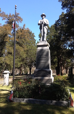
I then headed for where I knew I would find remnants of the siege. In Cedar Hill Cemetery stands an impressive Confederate monument, placed by veteran Thomas W. Smith after the war. A Civil War Trails marker here summarized the siege.

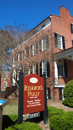
My most rewarding stop was at the historic home known as Riddick’s Folley (so named because it was such a large home, built after a fire, and there were no comparable homes at the time). A city-run house museum, I thankfully was spared the usual “rope bed, sleep tight” stories I dreaded. The enthusiastic guide took me through all four floors of the home.

The house was owned by wealthy businessman and planter, Nathaniel Riddick, but my interest was the fact that it served as General Peck’s headquarters during the siege. A view out the second story windows showed its importance. I could see past the courthouse to the north shore beyond the river, where the Confederates were positioned.

Inside Nathaniel Riddick’s office, my guide showed me one of their prized artifacts: a letter left by General Peck upon his departure to the homeowner. Acknowledging that he never met Riddick, Peck assured him that he treated his house respectfully and stated that he hoped to meet him under better circumstances. And it was true: the Federal troops did no damage. I was struck by how curious this war could be.

Upstairs Confederate prisoners were held, and there was graffiti by both Northern and Southern soldiers. One Confederate scrawled, “Go back home and stay there.” Nice and to the point, I thought. Another soldier from the 93rd New York neatly signed his name.

The house also displayed sketches and paintings done by Union soldiers while stationed here. There was an orderly Valley Forge type village of log huts surrounding the town by 1863.

The Suffolk campaign includes many topics which we could delve into more deeply, any one of which could be fertile for a longer discussion: Union garrison life in southern towns, the impact on southern civilians, foraging and food procurement by the Confederates, army and navy joint operations, contraband camps, etc.
I look for all kinds of history in my travels, so after finding what I thought I could of the siege, I went across town to find the Planter’s Peanut Center. By the way, downtown Suffolk, with a few antebellum homes still lining the main streets, has free parking (in contrast to my current home city of Richmond). Walking down the street, I turned into a rundown looking area, passing a grimy storefront with a Green Bay Packers flag in the window. In a nondescript building I found articles on the Planters Company, old peanut roasting equipment, and learned a little history of one of the area’s most significant crops. I left munching on the chocolate covered peanuts that I purchased, quite satisfied.
————
Bibliography
Davis, George, Leslie Perry and Calvin Cowles. Atlas To Accompany the Official Records of the Union and Confederate Armies. Washington, DC. Government Printing Office, 1891-95.
Hobbs, O. Kermit, Jr. Storm Over Suffolk. Suffolk, VA: Suffolk Nansemond Historical Society, 2007.
Official Records of the War of the Rebellion. Washington, DC. 1901.
Wills, Brian Steel. The War Hits Home. Charlottesville: University of Virginia Press, 2001.
Thank you for the tour of Suffolk. I’d bet that Battery Onondaga was named by General John J. Peck, a native of Onondaga County, New York.
Thanks Will, you are probably right!
Good stuff Bert!
Thanks Doug!
Dear Bert, I cannot thank you enough for this article. It sheds much light on what happened here. If I may, the NY soldier who signed his name was not from the 93rd. He was Henry Van Heeck from Company I of the 3rd New York Cavalry, as per New York State Division of Military & Naval Affairs:
https://dmna.ny.gov/historic/reghist/civil/rosters/cavalry/3rdCavCW_Roster.pdf
3rd NY Cavalry Battles and Casualties, taken from New York in the War of the Rebellion 3rd ed. by Frederick Phister (Albany:JB Lyon Co.) 1912 has that unit at a Battle at Suffolk, Va on March 15, 1865, where one enlisted soldier from this regiment died instantly, two other enlisted soldiers eventially died of wounds suffered that day, and two other enlisted soldiers recovered from wounds suffered that day, as per:
https://dmna.ny.gov/historic/reghist/civil/cavalry/3rdCav/3rdCavTable.htm
Thank you Patrick, and I appreciate your information, I’ll correct that in my notes.
Bert
Just moved into a new housing community and had someone stop by asking if I had seen a civil war grave marker on my land. I haven’t seen one but he said it was there when he was a kid and rode dirt bikes on the land. Could this been a grave site that was marked and removed by the developer?
Shame you couldn’t find fort Rosecran. I go there often. Most impressive. If you walked out behind that Chevrolet dealership, many Confederate fortifications to be seen. Suffolk is full of trenches and the like, you have to know where to look. My great , great grandfather was with the 14 th. I grew up here.