Mapping the Philippi Battlefield
Jon-Erik Gilot did a fantastic job at the 2019 Emerging Civil War Symposium filling in on short notice to give a talk on the battle of Philippi, see the video here. With limited time to produce another map, I’m grateful he chose a topic with perhaps the simplest troop layout. The bloodshed in what would become West Virginia paled in comparison to later fights. Some would even refer to the June 3, 1861 engagement as the “Philippi Races”—perhaps more fitting than calling it a battle. Without having to worry about laying out detailed troop positions, I opted to show a map that showed what the Union expedition hoped to attain and the lesser result they attained.
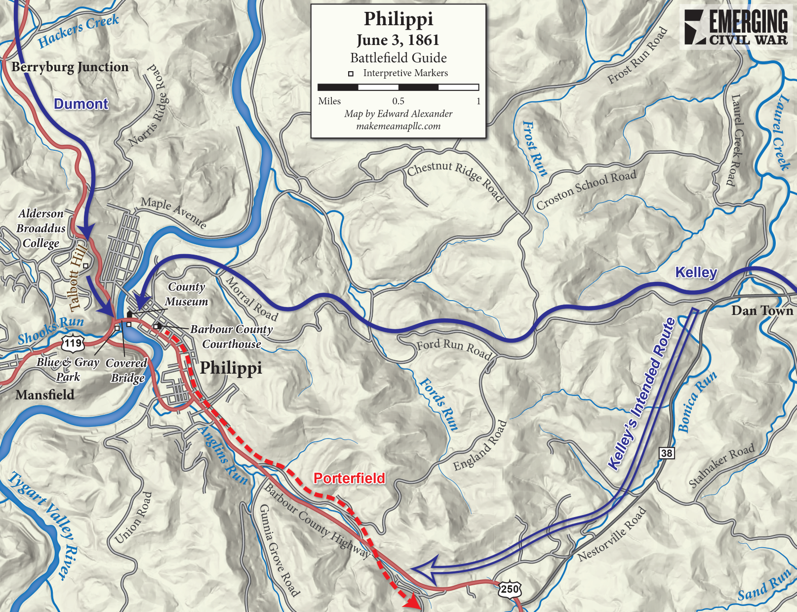
Protecting the Baltimore & Ohio Railroad was essential to Union strategy. Colonel George Porterfield’s Confederate garrison at Philippi posed a problem, particularly when a small party burnt a railroad bridge at Farmington on May 26. George McClellan sent a force down the Tygart Valley River to capture the town. The Union force divided before marching south. Colonel Ebenezer Dumont’s column followed roads west of the river while Colonel Benjamin F. Kelley’s men traveled east on the railroad as a feint before disembarking and marching south on the east side of the Tygart. Dumont had orders to pin the Confederate garrison in place while Kelley swooped in from the rear.
Heavy rain threatened to impede the columns, but the two Union forces remarkably arrived outside Philippi, on opposite sides of the river, at the same time. Unfortunately for the plan, Kelley departed from his intended route of march near Dan Town and took a northerly route that did not block Porterfield’s escape. Dumont’s men stormed across a covered bridge into Philippi, but already alerted to his looming trap, Porterfield led a safe retreat to Huttonsville.
Though there is no designated Philippi battlefield today, a visitor still has plenty to see. Civil War Trails maintains an interpretive wayside exhibit at the Union artillery position atop Talbott Hill (modern Alderson Broaddus College). The iconic covered bridge across the Tygart still stands below with municipal parks on either side and the Barbour County Historical Museum nearby. The battle is still commemorated each year. Though overshadowed by later, larger battles, Philippi still resonates locally and its importance in the war can still be felt with a visit after watching the presentation.
Good job, Jon-Erik.
Ed did the map.