Layers of History at Oak Ridge
ECW welcomes guest author Jon Tracey
When modern visitors come to Gettysburg National Military Park they often imagine the landscape as an untouched image of exactly how the battlefield appeared in July 1863. However, despite this ideal, the landscape has indeed seen many changes over the last 157 years, many of which would shock the average visitor. The carefully manicured fields that visitors now see were not always that way, and only deliberate effort has worked to return these fields to an approximation of the battle. It is neither a purely natural nor a purely cultural landscape, as each aspect has shaped the other. This is especially true on Oak Ridge, a small ridgeline located to the northwest of the town, the site of fighting during the early stages of the battle on July 1st. The first day of battle is often overlooked by scholars as well as visitors. Despite this lack of interest, this landscape has gone through many changes that define changing ideas of preservation. Prior to the battle, Oak Ridge was average farmland. Turned to a battlefield, parts were later preserved while other parts were torn down or even turned into an airport. Later, many modern intrusions were removed in an attempt to return the land to an image mirroring that of 1863. Truly, these many changes show a complex landscape, where layers have been added or removed. Nevertheless, each layer, though perhaps invisible now, is important to the story of the landscape.
Prior to that fateful July, Oak Ridge was simply another ridge outside a small town in south-central Pennsylvania. European settlement of the area, once a part of one of William Penn’s son’s private manor property, began in the 1740s with the establishment of small self-sufficient farmsteads. Formally established by James Gettys in 1786, the town slowly grew.[1] By the 1860s, Gettysburg was well known for the road network, and two major roads, both then and now, characterize Oak Ridge. The Chambersburg Pike, now Route 30, cuts across the southern end, while the less busy Mummasburg Road draws a line through the northern portion. Slightly north of the Chambersburg Pike was a deep cut into the diabase (hard rock) ridge, an unfinished railroad cut laid out in 1839 but unfinished during the battle.[2] The primary farms on the property included that of John S. Forney, near the Mummasburg Road south of Oak Hill, and the James Wills Farm, rented by William Job.
The same roads that brought prosperity to the town also brought the Union and Confederate armies to Oak Ridge on July 1, 1863. That morning, Union and Confederate troops met and clashed north of town for hours. By that afternoon, Union forces were forced to retreat through town. An 1897 history listed Union casualties on Oak Ridge as “707 killed and wounded and 982 missing, and those of [Confederates] opposing them [as] 955 killed and wounded and at least 1400 missing.” Though the battle raged across this landscape, the damage to property on Oak Ridge was not as bad as it could have been. On other portions of the battlefield, entire farm houses or barns were burned to the ground. In contrast, on Oak Ridge the damage was slightly less devastating. David Forney reported that his home and buildings were damaged by artillery, as well as damage done to his peach and apple orchards, “32 acres of wheat, 30 acres of timothy [grass], 10 acres of oats, and a 10-acre part of a cornfield” as well as 3,891 fence rails burned. Unsettlingly, his farm then became a mass grave as a result of Brigadier General Alfred Iverson, Jr.’s botched assault.[3]
Almost immediately after the battle, individuals began to purchase battlefield land for the express purpose of preserving it for future generations. The Gettysburg Battlefield Memorial Association (GBMA), the first organization to manage the purchase and preservation of the battlefield founded soon after the battle by local leaders, already owned 70 acres of land by June 1864.[4] Initially the GBMA’s goals were pure preservation, trying to leave the land as similar to the battlefield landscape as possible. However, early battlefield preservation tended to focus on other locations on the battlefield, such as Herbst Woods to the south of the Chambersburg Pike or positions south of town, so life on Oak Ridge continued as usual. Instead of the large purchases seen elsewhere, the GBMA only purchased enough land to build roads on. Veterans did not seem to place the same importance on Oak Ridge as elsewhere, and the GBMA underestimated future development, believing the fields would continue to be open farmland indefinitely.[5]

Perhaps the greatest change to the landscape during this period occurred in 1927 when John Forney’s son leased 66 acres for the creation of an airport. Contrary to modern preservationists who would scoff at the proposal, locals praised the airport as it could provide aerial tours of the battlefield. Finished that year, the airport boasted a turf field without concrete runways, a small office, a ticket booth, and a hangar that would accommodate two biplanes.[6]
The War Department worked to make the battlefield more understandable to the general public through the placement of iron and bronze tablets that detailed units and provided brief battle narratives. A step towards interpretation, these were still difficult for many visitors to understand. Additionally, they oversaw the construction of a 60-foot steel observation tower along Doubleday Avenue on the ridgeline, offering a spectacular view of the first day’s battlefield. This was one of several observation towers constructed at the time, and although it was shortened to 25 feet in 1968 due to wind concerns, it still remains a commanding presence on the landscape.[7]
In 1933, the battlefield was handed over to the National Park Service. By this point, the battlefield consisted of 1,723 monuments, 23.2 miles of road, and around 2500 acres.[8] Though previous groups had focused on commemorative aspects with only minor notes of preservation the early NPS management was focused on preservation and interpretation as their primary goals. Commemorative aspects were often altered to blend in with the natural environment, and only one major commemorative addition was made at Oak Ridge, the Eternal Light Peace Memorial atop Oak Hill. Prior to this point, battlefield managers had only purchased the lines of battle occupied by troops, as most outlying properties were still used agriculturally by local families. Now, however, commercial development began to encroach on the preserved land, such as the Peace Light Inn and proposed housing development on the airport.[9] Slowly but surely, the NPS began to purchase most land that remained in private hands along Oak Ridge.
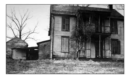
The creation of the Eternal Light is a process that the modern NPS looks back upon with some embarrassment. In 1937, the Pennsylvania State Commission purchased 33 acres atop Oak Hill and around the Mummasburg Road from the Forney family. This included the wartime Forney Farm buildings. The scene of heavy fighting, this farm suffered some battle damage, was used as a hospital, and was in a state of neglect.[10] Rather than repair and preserve them, however, the plan was to demolish them in order to present an open natural landscape around the proposed Eternal Light. Though the purchase was done by the state, the NPS was closely involved. Park historian Frederick Tillberg amassed a report on the structures, proving them to be in disrepair but still historically intact except for a postwar metal roof.[11] Showing the disdain for the building, this report was not done until after the demolition process had begun.
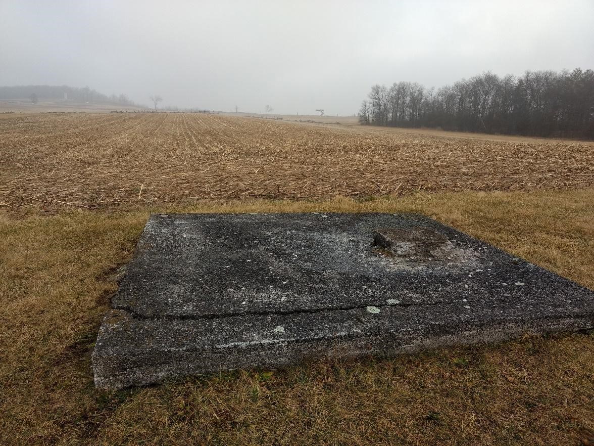
Eventually, intrusions like the Peace Light Inn and the Airport were purchased and removed. Oak Ridge indicates the many stages of change the landscape at Gettysburg experienced. This is not a frozen moment in time like many believe; it is a blend of commemorative and partially restored 1863 landscapes. Though there are subtle hints, such as the concrete foundation of the airport, many aspects of the landscape, whether they were there in 1863 or added in the 1900s, are now gone forever. Some changes, like the removal of souvenir stands and a motel, are generally viewed positively even though the structures were once a key part of the landscape. Others, like the loss of the Forney Farm, are much more controversial. Nevertheless, Oak Ridge is a complex landscape with many layers deserving of notice and interpretation.
————
Jon Tracey holds a BA in History from Gettysburg College and is currently pursuing a MA in Public History and Certificate in Cultural Resource Management from West Virginia University. He has worked as a park ranger for three seasons at Gettysburg National Military Park, and previously worked at Appomattox Court House National Historic Park, Fredericksburg & Spotsylvania National Military Park, and Eisenhower National Historic Park. His primary focuses are historical memory, veterans of the war, and Camp Letterman.
[1] John Auwaerter, Zhangshuai Wang, George W. Curry and Douglas Johnson, Cultural Landscape Report First Day – Union 1st Corps Battlefield: Gettysburg National Military Park (Boston: Olmstead Center for Landscape Preservation, Second Draft March 2018), 12-13.
[2] Ibid, 15.
[3] Ibid, 42, and Gregory A. Coco, A Strange and Blighted Land: Gettysburg The Aftermath of a Battle (El Dorado Hills: Savas Beatie, 2017), 71.
[4] Barbara Platt, “This is Holy Ground”: A History of the Gettysburg Battlefield (2001), 5.
[5] “Preservation of the First Day’s Battlefield,” American Battlefield Trust, Accessed March 2020, https://www.battlefields.org/learn/articles/preservation-first-days-battlefield
[6] Auwaerter et. al., 196.
[7] Platt, 22-24, and “Will Shorten Steel Tower on Oak Ridge,” The Gettysburg Times, September 24, 1968.
[8] Platt, 37.
[9] Platt, 37-39.
[10] Jennifer M. Murray, On a Great Battlefield: The Making, Management, and Memory of Gettysburg National Military Park, 1933-2013 (Knoxville: University of Tennessee Press, 2014), 34.
[11] Karlton D. Smith, “The Changing Faces of Gettysburg: The National Park Service at Gettysburg,” in Gettysburg 1895-1995: The Shaping of An American Shrine (Gettysburg: National Park Service, 1995).
Jon – Well written. -Troy Harman
Thanks Troy! Good to hear from you.
Jon,
Great article. Never knew about the airport. From the picture, it looks like you are looking east toward the Union line. How far is it to the Union position? I’d like to check it out next time I’m there.
Thanks. Keep up the good work.
Bolts
Hey Bolts.
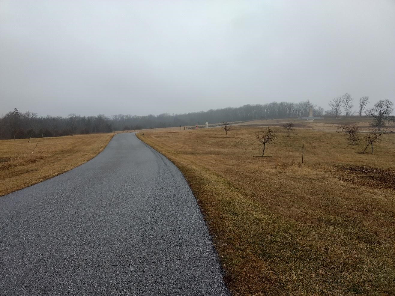
In the photo of the concrete foundation, that is at the intersection of Reynolds Ave and Buford Ave. The treeline to the right runs along the Union line at Oak Ridge. In the other photo, that is along Buford Ave facing the Eternal Peace Light, and Oak Ridge is off to the right. Hope that helps.
interesting thank you
I think an aerial tour of Gettysburg or other battlefields would be quite cool.
You forgot to include the (probably illegal) land “swap ” with Gettysburg College when a large chunk of the ridge near the cut was allowed to be sold to the Railroad and removed. Still haven’t heard a clear explanation of this or why no one went to jail.
Bill,
Yeah, that is certainly complicated; it could be a full blog post on its own! I decided to focus on earlier changes to the landscape for this entry.
The 2nd floor floorboards of the Forney house, shot through by a shell, are preserved at the Gettysburg Visitor’s Center museum. Visitors are impressed by the penetrating power of the civil war artillery. I volunteer there, and I’d like to put together a few more facts to go with this incredible display.