“Flat” Wilderness?

I’m always grateful for an opportunity to see a battlefield I know well with new eyes. Adam H. Petty’s book The Battle of the Wilderness in Myth and Memory: Reconsidering Virginia’s Most Notorious Civil War Battlefield (LSU Press, 2019), which offered a ton of cool stuff to think about. I reviewed the book for LSU’s Civil War Book Review, so in the interest of avoiding any spoilers, I won’t offer any details except to say I liked the book.
One comment Petty made in particular, though, really tugged at my shirtsleeve. He contends, “the Wilderness battlefield’s terrain was flatter along the Orange Plank Road corridor” as compared to the Orange Turnpike.
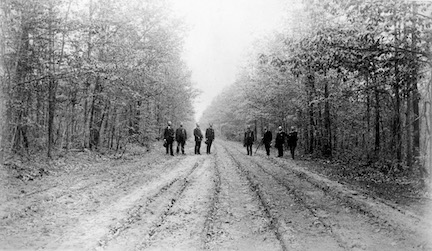
As someone who’s walked that battlefield extensively—and not just off the beaten paths but off any and all paths—I really felt like Petty got this one wrong, and it made me doubt how much time he’d actually spent on the battlefield. I’m firmly grounded in the school of thought that you have to walk the ground to fully understand what happened there (one reason I’m so passionate about battlefield preservation).
But, as I said, I liked Petty’s book. One of the things he does well is challenge myths and explores preconceptions about the Wilderness, and he gave me, as a historian of that battle, a lot of useful things to think about. So, I really wanted to give him the benefit of the doubt. What might he have seen about the landscape out there that made him come to the conclusion that the terrain is flatter along the Orange Plank Road?
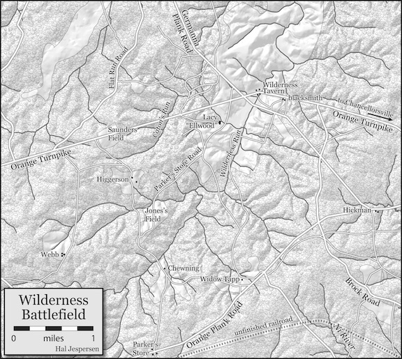
I started by thinking of the various pieces of flat terrain along the Orange Plank Road. Widow Tapp Field came to mind. So did the area to the southwest of the Brock Road/Plank Road intersection, where the Vermont Monument stands today.
But I thought of similar pieces of flat terrain along the Orange Turnpike. The open area around Ellwood has some gently rolling land but is relatively flat. Same with the area along the Confederate left flank, in the area where John Brown Gordon made his flank attack on the evening of May 6. But none of it is pancake-flat.
I thought more about some of those flat areas along the Orange Plank Road. The area where the Vermonters fought, for instance, drops off to the southwest toward an unfinished railroad bed. The north side of the road drops off pretty steeply toward Lake Wilderness. The area near James Longstreet’s wounding has a deep swale cutting right through it—deep enough that the 12th Virginia was able to cross the open road without being seen by Federal troops less than 100 yards away; on the far side of the road, they found themselves wheeling about and doubling back up a steep hill, where they soon accidentally brought grief to Longstreet.
I just couldn’t buy the idea that any of that landscape was any “flatter” than other areas on the battlefield.
A good look at a topo map might help, I thought. I first looked at the great maps Hal Jespersen had created for me for my book Hell Itself. The battlefield map indicated lots of uneven terrain but nothing with enough detail to shed fair light on Petty’s claim.
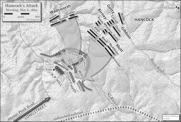
The topo lines on Hal’s map of Hancock’s attack had better topo markings, but it didn’t show the Orange Turnpike for comparison. Still, I didn’t get the impression from the map that there was much flat ground.
Next, I reached out to ECW’s resident cartographer, Edward Alexander (www.makemeamapllc.com). Edward once worked at Fredericksburg and Spotsylvania National Military Park, so he knows the Wilderness battlefield. I explained my conundrum and what inspired it, and asked if he could lay his hands on a good topo map of the battlefield. “As a cartographer and someone with knowledge of the ground, I’m curious what your take is,” I told him.
Edward pulled up a map and took a look. “I think I understand what Petty is saying,” he said. “Overall, the Orange Plank Road follows the top of a ridgeline, while the Turnpike just bulldozes its way straight forward.” Edward attached a map that showed the roads over top of shaded relief.
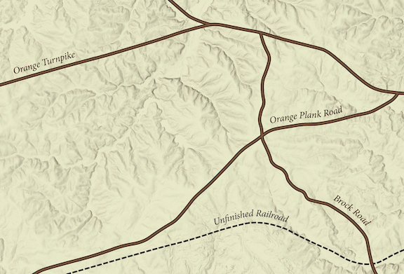
However, Edward also qualified his assessment. “Flat is a relative term,” he cautioned. “The Plank Road was designed to be easier for travel, but it still climbed and fell.” Where it branched away from the Turnpike at a point west of Mine Run, it was at an elevation of 330 feet. It drops down to Mine Run, and runs eastward, and by the time it reaches the Brock Road, it has risen to an elevation of 440 feet.
“It still follows the flattest route possible, while the Turnpike cuts straight through a few ravines and ridges,” Edward points out. Indeed, the Turnpike always looks like it arrows eastward while the Plank Road meanders through a number of wide, lazy twists and curves as it follows (mostly) the crest of a ridge.
At its highest point on the battlefield, on the western edge of Saunders Field, the Turnpike has an elevation of 420 feet. It would have dropped down to 250 feet at Wilderness Run (which the modern road doesn’t cross), and then rose to 290 feet by the time it neared Wilderness Tavern.
Edward pulled up some additional maps from the United States Geological Survey.

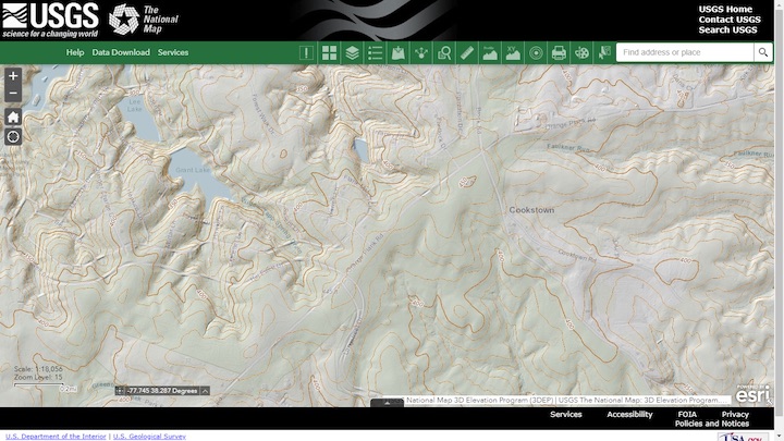
“A close look does show that the Turnpike has a crowded ridgeline compared to the more gradual slopes down from the Plank Road,” Edward observed. “It does seem to support the idea that the immediate area around the Plank Road is indeed flatter, though there are some significant ravines not too far away from the crest, particularly on the north side.”
The cartographer’s conclusion: “So, yeah, I suppose the Plank Road area has more gradual slopes, so it is technically flatter, but the area around the road still consists of unforgiving terrain.”
One walk into the woods anywhere north of the road makes that abundantly clear.
I’ll chalk this up as a “draw,” I suppose. In the meantime, I hope you have the chance to read it for yourself, and if you’re out on the battlefield sometime, I hope you get the chance to really walk the ground. Perhaps you can come to some conclusions of your own.
————
Read my BookChat with Adam Petty from October 2020 here.
Read my review of Petty’s book, The Battle of the Wilderness in Myth and Memory, from the LSU digital archives here.
Thanks for this Chris. Interesting. I thought the book was disappointing–really redundant and it could have been a long essay. Maybe I wasn’t in the right mood when I read it.
From my tramping off the beaten path, I would characterize the topography to be rugged, with ravines and, of course, imposing dense trees.
I agree! This guy has obviously not been on site. I did the Unfinished Railroad Flank tour for the 150th….anything but flat! Ravines and streams all thoroughout !! I can still remember Greg Mertz warning this will not be an easy hike….REPEATEDLY before the tour.
After more than 25 years of exploring the Wilderness battlefield, I have noticed more severe and undulating terrain immediately north and south of the Orange Turnpike compared to the Orange Plank Road. As Edward Alexander mentioned, the Orange Plank Road was constructed along a ridge line and is mostly “flat,” although one can certainly find cuts and draws north and south of the road. However, these terrain features are not as dramatic as one will find south of Saunders Field, for example. All that being said, modern development immediately north of the Orange Plank Road (Lake Wilderness) and on the Union army’s far right flank (6th Corps sector) has destroyed the rolling terrain that the soldiers encountered in 1864. Flooding a small stream to create “Lake of the Woods” did irreparable harm.
I love any discussion of this Battle, which I could argue was the most significant one of the war, if only because of Grant’s stolid reaction to the enormous bloodletting.
This review touches upon an important phenomenon of the Civil War that applies universally to the major battlefields we are all familiar with…that is the importance of “high ground”. I am a product of the far West and grew up (well, let’s just say grew older) in the Olympic Mountains of Washington State…the highest peaks rising to a bit over 8,000 feet. In the mid-1960’s I moved to north Alabama where I resided for almost 8 years. The difference in the terrain in the South quickly became obvious. As my interest in the Civil War grew through time I happened upon a long forgotten book whose author did a masterful job of explaining that a mere few hundred feet of elevation could offer great advantage to artillery and infantry in resisting attack. Culps Hill, Little Round Top, Snodgrass Hill, and many others quickly come to mind and correctly hold their place as historically significant in the outcome of the associated battles (I’ve walked them all). I’ve heard others make critical comments on battlefields, typically “That’s not a hill”, in reference to a position (apparently being products of other parts of the country with snow-capped peaks) as if they were somehow responsible for their very existence. But, if you walk these fields with an eye for tactical advantage and put yourself for just a moment in the place of the principals who chose those sites and fought to hold them you will quickly perceive their critical importance…just as Chris has done in this instance.