The Fight at Picacho Peak
ECW is pleased to welcome back Gregory L. Wade.
Tourists often visit the Phoenix area for its near-perfect winter climate, the incredible desert scenery, or to learn about Mexican or Native American history. Not many people realize that the Civil War touched this scorched ground just a few miles north of Tucson in a fight known as the Battle of Picacho Peak.
Only one hundred miles from the famous shootout town of Tombstone, this “battlefield” is a very easily accessed bit of largely unknown history. The April 1862 fight is sometimes recognized as the western “high water” mark of the South during the Civil War.
The Confederacy coveted the Arizona territory for its access to west coast ports and their trade routes, not to mention the South’s intentions to maintain a balance of power continent wide. Also, California gold was desperately desired, and they needed open transit avenues to maintain authority, while moving men and materials all the way to the Pacific. Just as importantly, the ability of Arizona’s Pima and Maricopa Indians to produce large amounts of surplus wheat and other crops was of great interest among military planners, North and South. Finally, having cross country access would add clout to the Confederacy’s pitch to Europe about its legitimacy as a coast-to-coast nation.
Some saw cotton as a future opportunity for the region as well since the crop had existed in the area for hundreds of years among the natives. While not a major commodity in trade at that time, there were those who could see its potential in a climate suitable for planting, assuming there was water. A few decades later, cotton became a major Arizona crop with improved irrigation techniques and hardier strains of the plant.
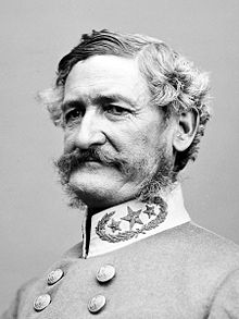
At the start of the Civil War Federal troops were often withdrawn from California and the territories of New Mexico and Arizona to serve in the East. Widespread scuttlebutt of Federal soldiers leaving California and marching to the Arizona Territory were mostly rumors while the exit from California of major numbers of troops left a vacuum the South planned to fill. During his campaign into New Mexico, Confederate General Henry Sibley dispatched about one hundred troops to Tucson led by Captain Sherod Hunter. He wanted an early warning of enemy troops approaching New Mexico where he was campaigning while trying to gain control of that territory. Sibley was a West Point graduate who had experience in the Seminole and Mexican Wars. His lasting claim to fame was his invention of the Sibley tent used by the Union during the War. Now, he would have a major role in the Confederate effort to conquer the West.
Native Tennessean Sherrod Hunter’s contingent raised the Confederate flag above Tucson in February of 1862, proclaiming it the capital of the Arizona territory. His garrison served as an early alert to any Federal probes from the west as well as keeping an eye on nearby Apache bands. In 1861, Hunter, who left Tennessee in 1858, had been driven from his ranch in New Mexico by Apache’s and soon joined the Arizona Rangers, rising to the rank of captain. Sibley was preparing to invade New Mexico from Texas in early 1862 and ordered Hunter to occupy Tucson as scouting and observation post against approaching Union troops.
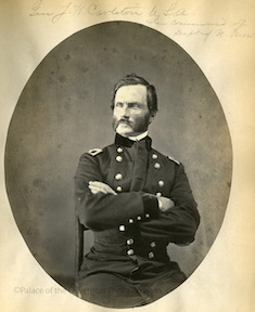
To counter the Confederate foray into the territory, a contingent of infantry, cavalry and artillery was sent from California under the command of Col. James Carleton. His superiors in Washington assigned him about 1,500 men from California to stop any threat from Sibley. A plan from Brig. Gen. George Wright, commander of the Department of the Pacific, pointed out threats that included a Rebel force in the “vicinity of Tucson” spurring the movement of Carlton’s troops.
The Federals march east was incremental in small groups because of limited supply stops in this harsh country. Nevertheless, their numbers would overwhelm the Confederates modest forces. The forty-eight-year-old Carleton planned to sweep Arizona of Confederates and by March his men, known as the California Column, finished stocking provisions at various points along the Butterfield Overland Stage route for an advance on Tucson. For his part, Hunter sent details to destroy these stockpiles where he fought several brief skirmishes including one near Yuma, marking the furthest west fight during the war.
A lot of fighting for control of the region occurred in New Mexico including the Confederate “victory” at Glorieta Pass in March 1862. While technically a victory, it was followed by a retreat resulting in the Confederate demise in that territory. It also marked the beginning of the end of Sibley as an important commander. But Captain Hunter apparently had not yet heard of the loss or of Sibley’s long retreat from Santa Fe back into Texas. He planned to keep the Federals under watch in Arizona, keeping track of them with scouts scattered across the Sonoran Desert.
On April 15, 1862, a small detail of Federals under Lt. James Barrett of the First California Cavalry was sent ahead to the Picacho Peak area searching for Confederates reported by locals to be in the area. They planned to capture prisoners for information or the location of other Confederate formations in the vicinity.
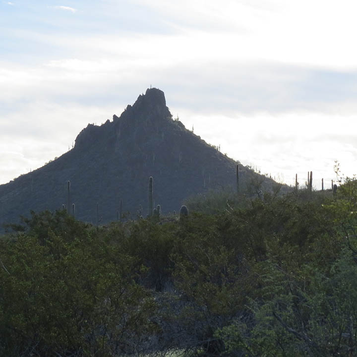
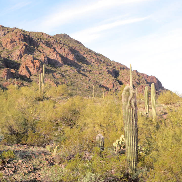
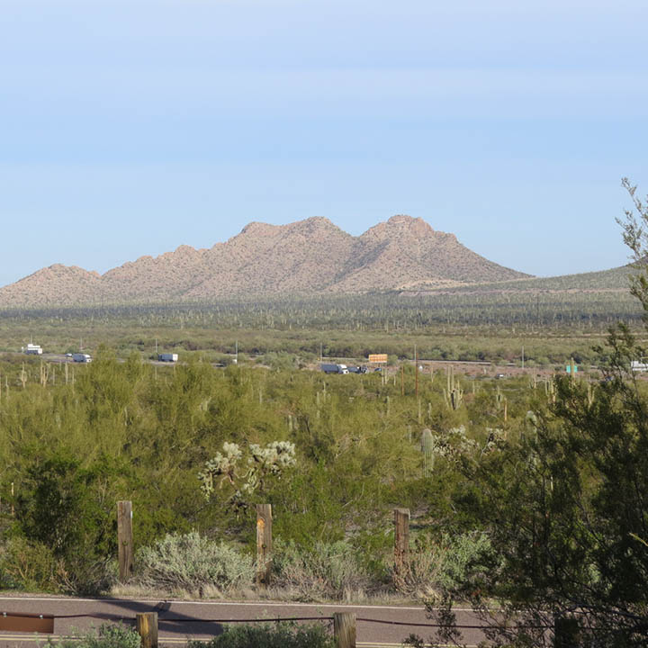
The peak itself is an erosional remnant of volcanic rock that stands 1,500 feet over the desert between Tucson and Phoenix and just a musket ball shot from Interstate 10. In years past, the tower was used as a landmark by those traversing this part of Arizona. The area is dry and rough with little tough vegetation such as the iconic Saguaro cactus, brittlebush and ironwood.
Barrett was to swing around the north side of the mountain with twelve soldiers while another officer, Lt. Ephraim Baldwin with twelve troopers, was to come from the south to capture Confederates camped at Picacho’s base. Barrett arrived before Lt. Baldwin and was not supposed to engage the Confederates under Sgt. Henry Holmes but instead wait for additional support. Totally surprised, the Confederates were in the process of surrendering when Barrett, his men still mounted, opened fire. The Southerners, fearing for their lives, returned fire and retreated into the brush and rocks while pursued by the mounted Barrett who was mortally wounded in the neck. Sgt. Holmes was captured, and the fight continued almost two hours before the remaining Confederates managed to escape.
Three Federals were killed and three wounded while two Confederates were wounded and three captured out of ten men (Confederate casualties were not confirmed). The rest of Holmes Confederates made their way back to Tucson where they warned of the approaching Federal column. Hunter and his men abandoned Tucson in early May and retreated to New Mexico while the Federals entered the town unopposed a few days later.
The Battle of Picacho Peak was the farthest western fight with fatalities of any Civil War action. While the numbers involved and casualties are modest compared to other battles, it marked an emphatic end of Confederates hopes to control a route to a west coast port. The bodies of the two Union soldiers killed were removed and interred in the National Cemetery in San Francisco. Barret’s body was buried in an unmarked grave on the battlefield believed to be in the vicinity of the current rail line. His final resting place was referenced in a report by a Lt. Shinn when his detail “passed graves of Lieutenant Barrett and two soldiers on the left of road” while on a June 1862 march from Fort Barrett in the Pima Villages (named after the deceased) to Tucson. Today, the graves’ location is unknown.
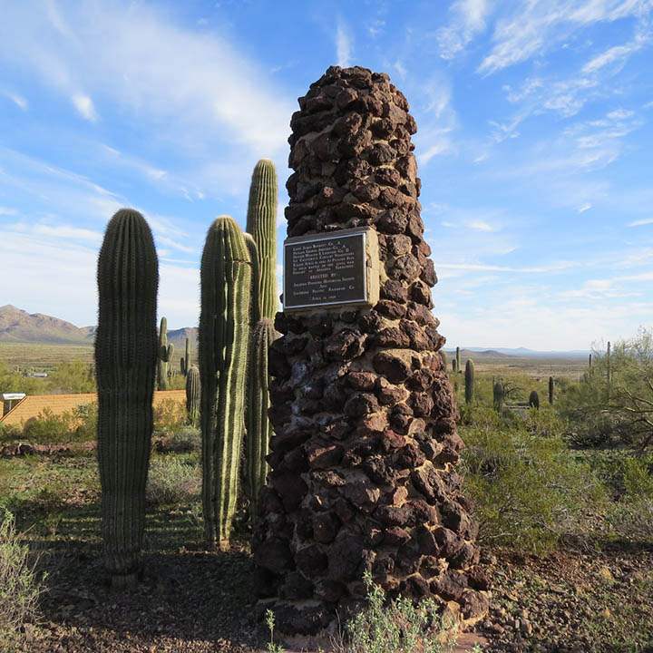
An Arizona state park provides camping and hiking nearby along with interpretative markers about the battle. In 1846, another military event occurred by the Peak when the Mormon Battalion camped there after an arduous march with little food and water. In 1937, an interpretative plaque was placed noting the battalion was the first to fly the flag of the United States in Tucson.
The Battle of Picacho Peak was part of many disjointed and unsuccessful moves by the Confederacy to obtain a west coast route while planning on occupying most of the Southwest. After Confederate reverses and retreats, the region would focus more on Indian hostilities than the Civil War.
Picacho Peak, a windswept tower known more for hiking and rock climbing than fighting, holds the sad distinction as the country’s most western site where soldiers died in Civil War combat. And perhaps fittingly in such a beautifully bleak place, one of those killed remains on post in an unmarked grave.
Gregory L. Wade has written for several history publications and is the founder of the Franklin Civil War Round Table. He has been involved in the preservation and reclaiming of about 150 acres of the ground involved in the main 1864 Battle of Franklin.
————
Sources:
Bob Ring, Ring’s Reflections: Cotton Still Thrives in Arizona, Arizona Daily Star, April 14, 2014
Roger Naylor, Arizona’s Military History: Battle of Picacho Pass, Republic, March 13, 2015
Sherman L. Fleek, History May be Searched in Vain: A Military History of the Mormon Battalion, 294.
David H. Dejong, The Granary of Arizona: The Civil War, Settlers, and Pima-Maricopa Agriculture, 1860-69,. The Journal of Arizona History, Vol 48, No 3, (Autumn 2007). Pp 221-256 (JSTOR)
Jonathan DuHamel, Geologic Field Guide to the Southeast Picacho Mountains and Picacho Peak, Pinal County, Arizona. Arizona Independent News Network, November 26, 2017
Official Records of the War of the Rebellion, Series I, Vol 9, page 599. Shinn Report.
Great summary of this often-forgotten skirmish and excellent images as well that really show the geography.
Love to see more Southwest posts!
Thank you for this post!
I have been to the battle reenactment numerous times. It is sad that the Ranger in charge of that National Park will not have the reenactment take place because of foolishness of being politically correct.
My family passed by Picacho Peak in the 1950’s, when I was a young girl, on our way to Tucson. My father stopped at all Historical Monuments (that was a family law) and we stopped here to get drinks of water out of an existing hose bib. Someone asked, “I wonder why they fought here?” To which my teenage aunt replied, “Because there was a drinking fountain “. I still laugh at the remembering and 70 years later the family joke still survives.