Following Old Roads
I love old roads! There’s nothing more thrilling than pouring over a map or thrashing through the woods and finding an old remnant, and thinking about who travelled that long-lost spot in the past. I look for old roads all the time and use maps daily along with other documents to find old roads that have fallen out of use. Neglect, straightening, bypasses, and urban encroachment all distort the location of old roads, but if you look long enough you can often find their trace.
The June 29, 1862 battle of Savage’s Station is one of the forgotten battles of the war. Part of the Seven Days’ campaign outside of Richmond, it was a Union rear guard action to hold off pursuing Confederates. The bulk of the Army of the Potomac was moving south to the James River, and Confederate forces under Gen. John B. Magruder advanced to engage, while Gen. Jackson would support him.
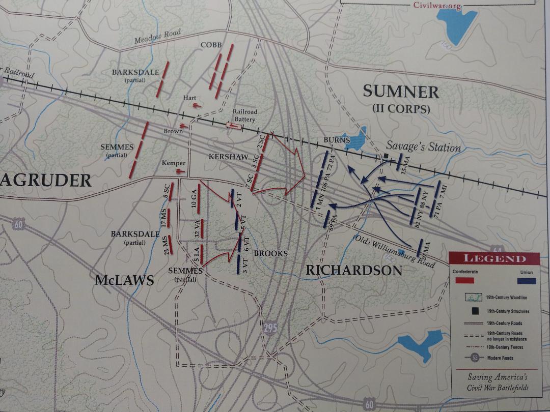
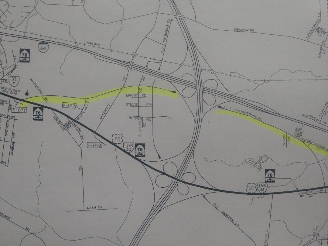
The heart of the battlefield unfortunately was destroyed by the construction of Interstate 295 east of Richmond, built in the 1980s. In fact the cloverleaf interchange between Interstates 295 and 64 seem to be built though the very center of the area of fighting. V-DOT could not have planned it any better. Yet it is still possible to access peripheral areas and the Union and Confederate approaches along the Old Williamsburg Road. This was the wartime road, later replaced by US. 60, now called Williamsburg Road.
See the map below and note how traces of Old Williamsburg Road can be seen on each side of 295. I’ve driven to the dead end on each side many times, and it’s a regular stop for tours I give that feature the battle of Savage’s Station. Thankfully there are only a few homes along these stretches, and there’s even some farm fields still in use. There are also two original wartimes structures, one on each side of the interstate.
In this area the 1st Minnesota fought against Kershaw’s South Carolinians here. It was some intense fighting. Sergeant Augusts Dickert of the 3rd South Carolina wrote “The troops bounded to the front with a yell and made for the forest in front, while the batteries graped us as we rushed through the tangled morass. The men became woefully tangled and disorganized and in some places losing the organization entirely . . The graping was simply dreadful, cutting and breaking through the bushes and striking against trees.” A Minnesota soldier recalled, “We held the position . . . without yielding an inch, and about sunset the Vermont Brigade came up on our left and in a last counter attack, the enemy was driven back.” The 5th Vermont lost 209 of its 428 men, nearly half.
The Philadelphia Brigade fought here as well. Alfred Hills of the 71st Pennsylvania recalled an incredible incident: “Our skirmishers immediately became engaged with the enemy who fought from the cover of the woods, seldom showing himself in the open ground. I remember seeing a rebel attempt to run stooping from one tree to another, but as he was shot, and turned a summersault which would do honor to a skilled gymnast when he fell.”
The Union troops pulled out, destroying as much of the supplies stockpiled at Savages’ Station as they could before departing. About 3,000 sick and wounded were also left to the enemy. The exhausted Federal regiments moved east at dark, following in the wake of the rest of the army on its way to the James River.
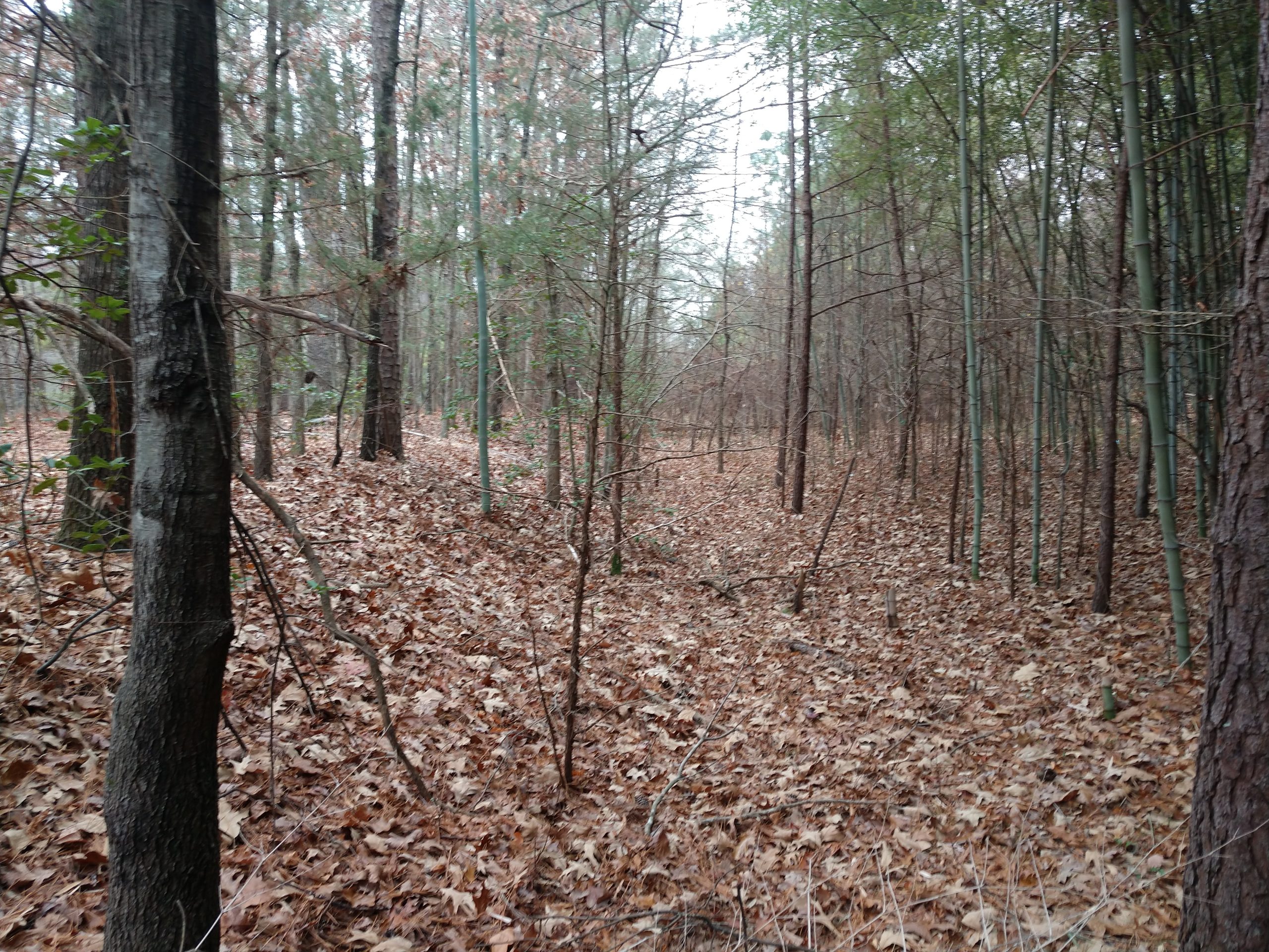
Having accessed both ‘ends’ of the old road, I was determined to get to the part that is now gone. I made the effort to walk the missing ‘link’ of the road one Sunday morning, before traffic was too heavy. I started by walking across the exit ramps and the four lanes of I-295 (not recommended). Sure enough, right where I thought it would be, I found the old roadbed in the median, covered by thick woods and underbrush.
This spot is a two-for one: in June, 1781 The British army under General Charles Lord Cornwallis marched east from Richmond on this very road towards Williamsburg and eventually Yorktown. Following were Continental troops under General Lafayette.
Standing in the roadbed, thinking about the thousands of troops who fought here and marched through here, and all the famous people who passed that way, was exciting. I enjoyed my discover as the sound of traffic buzzed in the background.
Great article, Bert. Loved the Lafayette/Cornwallis connection also. Hard to imagine the Virginia DOT just HAD to put the Interstate interchange in this exact spot. Good grief.
Thanks Mike. Its amazing, they couldn’t have put it more in the middle of the battlefield if they tried.
Nerdgasm! Much appreciated, Bert. Now I have to go walk the road trace south of 64.. I had no idea it was there. Your comment about nothing be more thrilling than finding an old road trace reminds me of telling Chris Mackowski that most of my (non-history nerd) friends don’t understand why I take pictures of mounds of dirt (remnants of works on battlefields) when I come back from a trip and show my photos. He was showing me the works at Stevenson Ridge. As I said then, how is it that no girl ever snatched me up?? LOL!
Thanks Glen, we all have our obsessions!
Great article. To borrow from “Confederates in the Attic”, crossing over 295 on foot was “super hard core.”
Ha! Yes it was! Not the first time I’ve risked life and limb for history. Nor the last….
And just think, we now have a vista that features a field of solar panels!
Kudo’s to you Bert for finding a creative way to deliver the Savage’s Station story.
Also, not far away from where you wrote about, the construction of I-64 entirely wiped out where the June 1 Fair Oaks fight occurred below the railroad tracks.
Thanks Vic. YES. And I think about that lost part of the action every time I drive by.
Awesome — how cool is that?! My favorite type of “discovery” and a two-for @ that.
Abandoned roads and trails offer rewards to those who seek them out. Well done and thanks.
Great article Bert. There is also a good vantage point in the SE quadrant of the cloverleaf, between I-64 and Williamsburg Road. William B. Franklin left a good account of watching the developing fight there in the company of John Sedgewick. A column of troops approached which the two Union general mistook for Edwin Sumner’s troops. They turned out to be Confederates. The generals had to feign a casual attitude to make their escape.
Thanks Ben! I’ll look for that!
Great stuff Bert!
Bert: Thanks for this excellent post. Those of us obsessed with this campaign cannot get enough in the way of new insights and terrain analysis.
Excellent piece of writing, Bert. I was there a number of years ago and everyone in my group was saddened by the destruction of this battlefield. Your post nicely covers the battle and is a wonderful exposition of the need to preserve hollowed ground.
What an interesting post for us diehards! Thank you!
Great work showing the battlefield and modern day mapping
Awesome!!