Discovering Long Lost Earthworks
I spent many summer vacation evenings during high school playing baseball in my friend Scott’s backyard. The field had tiny dimension so we used a wiffle bat and wrapped duct tape around a wad of cotton for the ball. Hitting it into the sheep pasture awarded you a home run and most backyard games turned into home run derbies. Even my 5’2 frame (at the time) could occasionally slink a blooper into the pasture. Our frequent tread around the bases wore a distinct diamond into the grass.
In 2005 the Google Earth software was released to the general public. I was always fascinated with maps and traced many familiar places from overhead. I panned over to Scott’s house and sure enough the aerial imagery showed our field.
I marveled at the time about the wonders of technology but could scarcely imagine that a decade later I would be going back to the same software to discover long lost Civil War fortifications.
I recently read a fascinating article in the New York Times about the discovery of ancient earthworks in Kazakhstan using the Google Earth software. Memories of discovering the diamond by the sheep pasture flooded my brain but I then began to wonder what sort of information I could glean from the air about the miles upon miles of entrenchments constructed during the Petersburg Campaign.
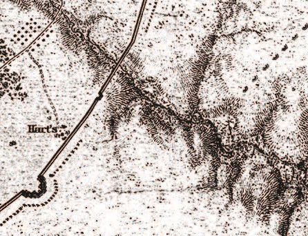
One particular fortification I was interested in was the Six-Gun Battery located on Mary Hart’s farm in Dinwiddie County. Mrs. Hart’s restored house still stands along Duncan Road about a mile below its intersection with the Boydton Plank Road. The Confederates’ need to protect the supplies traveling up the plank road meant the construction of massive fortifications across the Hart property.
Confederate infantry from Lt. Gen. A.P. Hill’s Third Corps was oftentimes scarce to protect the Boydton Plank Road but gunners supplemented this deficiency with up to thirty twelve-pound Napoleons and three-inch ordinance rifles. “At every few hundred yards of this line were forts or batteries well supplied with artillery,” claimed Maj. Gen. Horatio G. Wright whose VI Corps attacked the works on April 2, 1865. “These lines must been looked upon by the enemy as impregnable, and nothing but the most resolute bravery could have overcome them.”
In between the homes of Mary Hart and Esek Steere stood one of the most dominant positions–a powerful artillery redan that contained six pieces. The fire from these guns tore through the ranks of Maj. Gen. Truman Seymour’s division as they charged through the dim light at dawn of April 2nd. Many of Col. J. Warren Keifer’s brigade swarmed over the works further to the north along Arthur’s Swamp and swung to the left to support Col. William S. Truex’s brigade who charged straight for the Six-Gun Battery.
Corporal Oscar Waite of the 10th Vermont reached the battery among the first of the Truex’s Federals and later described the hand-to-hand combat within its walls in graphic fashion:
I had long considered “bayonet exercise” my best hold, but on landing inside the fort found myself confronted by a lank six-foot rebel, who kept me so strictly on the defensive that I soon lost all conceit and backed off to where there was more room. My gun was loaded all this time, but I dared not lose my guard enough to fire.
While in the midst of this general mix-up I caught a glimpse of a clubbed musket almost whistling horizontally toward my head. The proper move would have allowed it to slide over, but that would give my first opponent the chance he was looking for. By partly parrying, though, the only result was a glancing kind of shave that laid about half of my left eyebrow over on the other half. At the same instant, catching the first rebel off guard, I let go the small of my gun-stock with my right, and struck straight out with the butt of my gun, which reached the fellow’s chest and “floored” him. Then just as I turned to the clubbed-musket man, someone collared him from behind and pulled him over backwards.
In about a minute the whole fracas was over, and the prisoners, said to be only 35 with whole skins, were marched to the rear. Then I laid that loose flap of eyebrow in place, wound a handkerchief around it, and as soon as the blood dried was able to remove the bandage. This was the first blood that the real graybacks had ever drawn, in my case, and I was really glad of something to show.
The blue wave continued to crash along the Confederate entrenchments until it reached Hatcher’s Run, slicing a four mile gap in Hill’s line. This combat destroyed any southern hope of holding the lines at Petersburg and defending the capital at Richmond.
A surprising amount of these earthworks remain in an impressive state today. Pamplin Historical Park preserves a mile of the line from Rohoic Creek to an artillery redan just below the middle branch of Arthur’s Swamp. The Confederate line disappears at it runs through Mary Hart’s backyard, long since turned under the plow. It is still visible at various locations further to the south and picks back up once more in a long, uninterrupted stretch on the Civil War Trust’s large tract at Hatcher’s Run.
The Six-Gun Battery is unfortunately among the missing stretch. It survived until at least 1934 but was destroyed sometime in the mid-20th century. An expansion of Duncan Road in the 1990s further altered the landscape. For the first four years that I worked at Pamplin Historical Park I believed the battery’s exact location would remain a mystery. I knew of its general proximity but there was nothing left on the ground to validate a precise position.
But what about clues from the air?
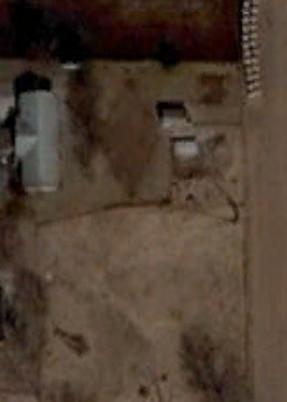
Inspired by the New York Times article I loaded up Google Earth and scanned the approximate Confederate line as it wound its way from Battery 45 to Hatcher’s Run. As I passed the Hart house on the map and continued to scan the hay field to the west I found a ribbon with a darker green color than the surrounding field. This ribbon appeared in line with the approximate location of the lost Confederate earthworks and when it reached Duncan Road the ribbon bowed in a small arc to the south just as the Six-Gun Battery did. No historic or modern maps show a road or farm lane in this location and the terrain is such that it could not be a water drainage causing the discoloration.
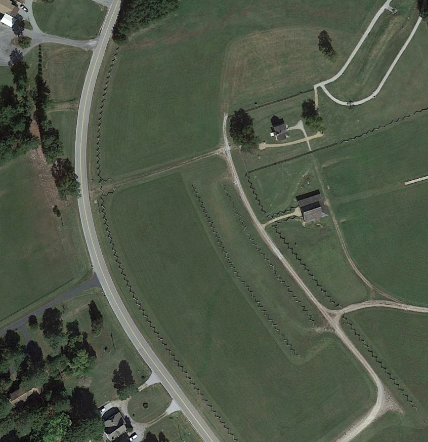
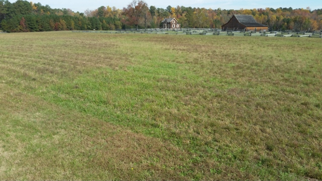
The latest aerial image was taken in October 2014 and just after a hay cutting. Pamplin Historical Park did not acquire the tract until the 21st century and elected to let the grass grow across this barren landscape during the warm weather and periodically cut it for hay. I went out now in November 2015 after another recent hay cut and found the grass again appeared as a darker green color where it could be presumed that the battery was located. I had never noticed this distinct path in the past. Google Earth allows you to view a timeline of aerial shots. The ribbon is not as visible in the summer or winter but maintains a clear distinction during the spring and fall.
I wish I knew more about geology to develop a scientific hypothesis. I would venture a guess that the soil where the earthworks were turned under the plow in the last eighty years causes a slightly different interaction with the seed and the grass grows and fades at a slightly different rate than its neighbors. Perhaps it’s an entirely different seed that took root along this section. For whatever reason it may be, the shadow of the Confederate entrenchments appears to be visible for a brief period at the change of the season.
I would be interested to hear feedback. Perhaps my hypothesis is full of holes but the ribbon matches precisely with where the Six-Gun Battery ought to be. The Virginia Department of Transportation conducted an archaeological survey along Duncan Road in the early 1990s–before Pamplin Historical Park had acquired the property–and found clear indications that support my own findings. Of course they nevertheless went ahead and continued with the expansion of Duncan Road that further disturbed the slight ridge that the Six-Gun Battery occupied. VDOT also did nothing to mark the battery’s location on the ground.
To this date no interpretive markers distinguish this important position along the Confederate entrenchments. Because nothing remains of the battery we barely talk about it at the park. But you’d best believe I’m working on plans for a tour of Truex’s attack. I’m thinking next fall after the hay is once more cut will be the best time for such a venture.
Edward–what a wonderful article! The gentle swath of brighter green may well be what you hypothesize. We are the luckiest historians in the world to be living in a century where technology is such a helpmate. Huzzah!
Jolly good read !
Fascinating! What an awesome way to use Google Earth. I think your hypothesis makes sense and hope it can be proved conclusively. I assume Mary Hart had probably left her home during the siege? Perhaps she or other family members wrote an account if they returned later? Sometimes civilians made comments about changes on their property which might be a useful clue. Just a thought…
I have read in “The Guns of Yorktown” that once the top or plowed layer was removed, the outline of the French and American trenches and fortifications could be seen in the dirt (the color was different), and it was on top of these that the current structures where built. So no doubt the same would be true with Civil War structures.
Fascinating post! That’s a great use of technology to facilitate research.