ECW Weekender: Maryland Heights Overlook (Harpers Ferry, WV)

With cooler weather and autumn foliage on the way, it might be a good time to break-out your hiking boots, if you like to explore history in the great outdoors. How about a hike to see this view?
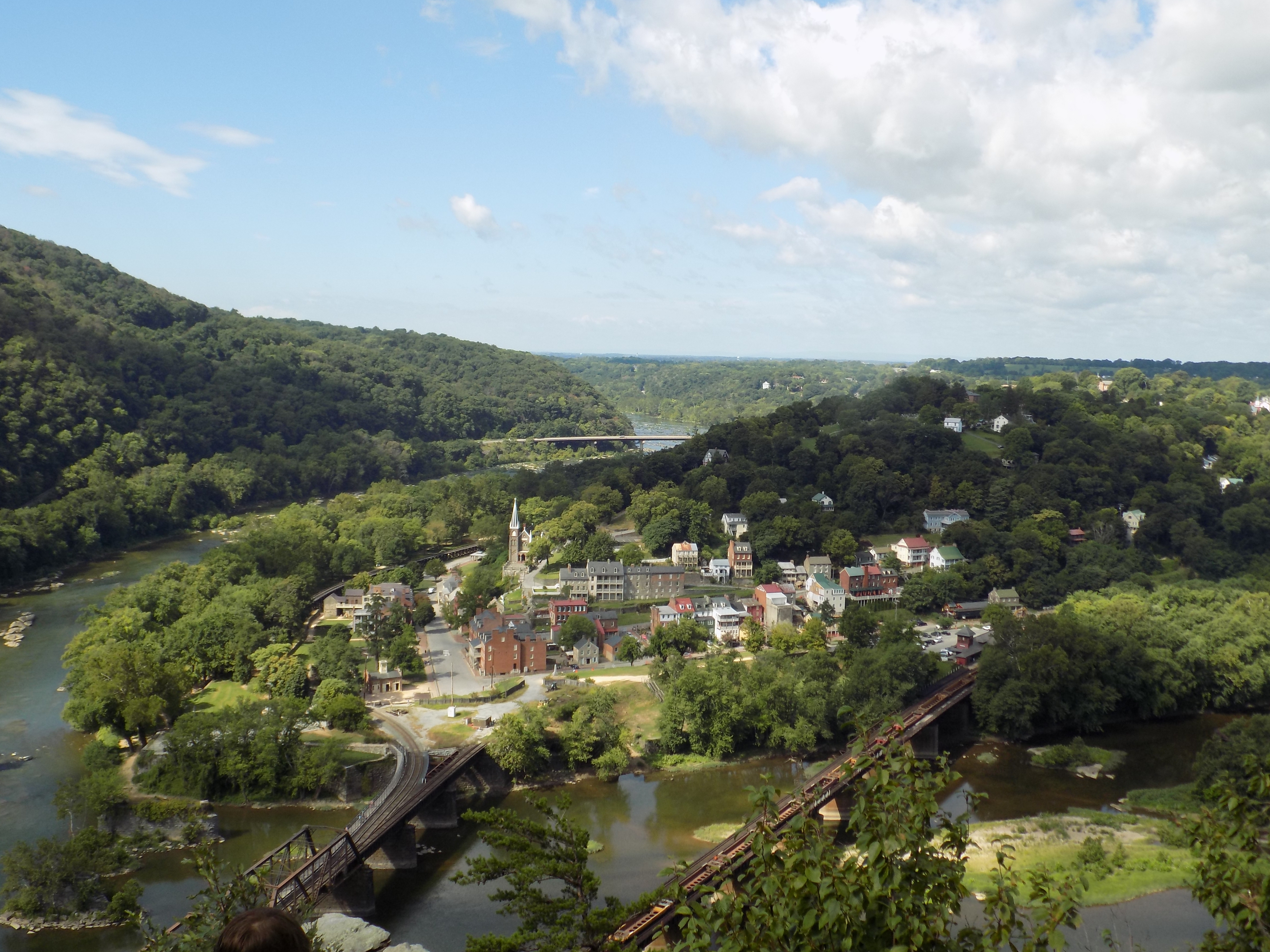
This is the view of Harpers Ferry from the Maryland Heights Overlook. And here are some trail tips, how to get there, and historical details:
First, be prepared for strenuous activity; the trail is very steep. Second, if you are hiking alone, try to go on the weekend when there will be more people on the trail. Third, take lots of water and a snack.
Drive to Harpers Ferry National Historic Park, pay the entrance fee, and park at the visitors center. Check-in with the rangers and ask for a trail map for Maryland Heights. (I like to ask about trail conditions in case there have been any recent changes.) Take the visitor bus shuttle down to the historic town. Walk through on the main street, pass John Brown’s Fort, head for the river, and cross on the pedestrian bridge. (Warning: there are no facilities on the trail; prepare accordingly.)
It’s about 4.1 miles roundtrip from the railroad bridges to the Overlook.
Following the directions on the hiking map, you’ll enjoy a nice stroll along a flat dirt path before you cross the road and arrive at the trail head. As you stroll, notice the big ditch to your right; in the 1850’s and 1860’s this was the Chesapeake & Ohio Canal, used to transport produce and other products on flat-bottomed barges pulled by mules. At this point you’re walking along the mule and teamster footpath. There is a canal lock that’s fun to explore and a great photo opportunity. (And don’t forget to enjoy the gorgeous views of the Potomac River to your left.)
When you arrive at the trailhead, it’s decision time. This is what you will see:

It’s a steep incline and it doesn’t get any flatter or downhill until you turn around. Ready, set, go!
As you climb higher and higher, pause to enjoy the view or the silent woods and remember some of the history in this beautiful location. The path that you are hiking was actually a road built by Union soldiers in of the 2nd Massachusetts Infantry; it was a retreat road on September 13, 1862, when the Union troops abandoned the heights and retreated back to town after a surprise by “Stonewall” Jackson’s troops.
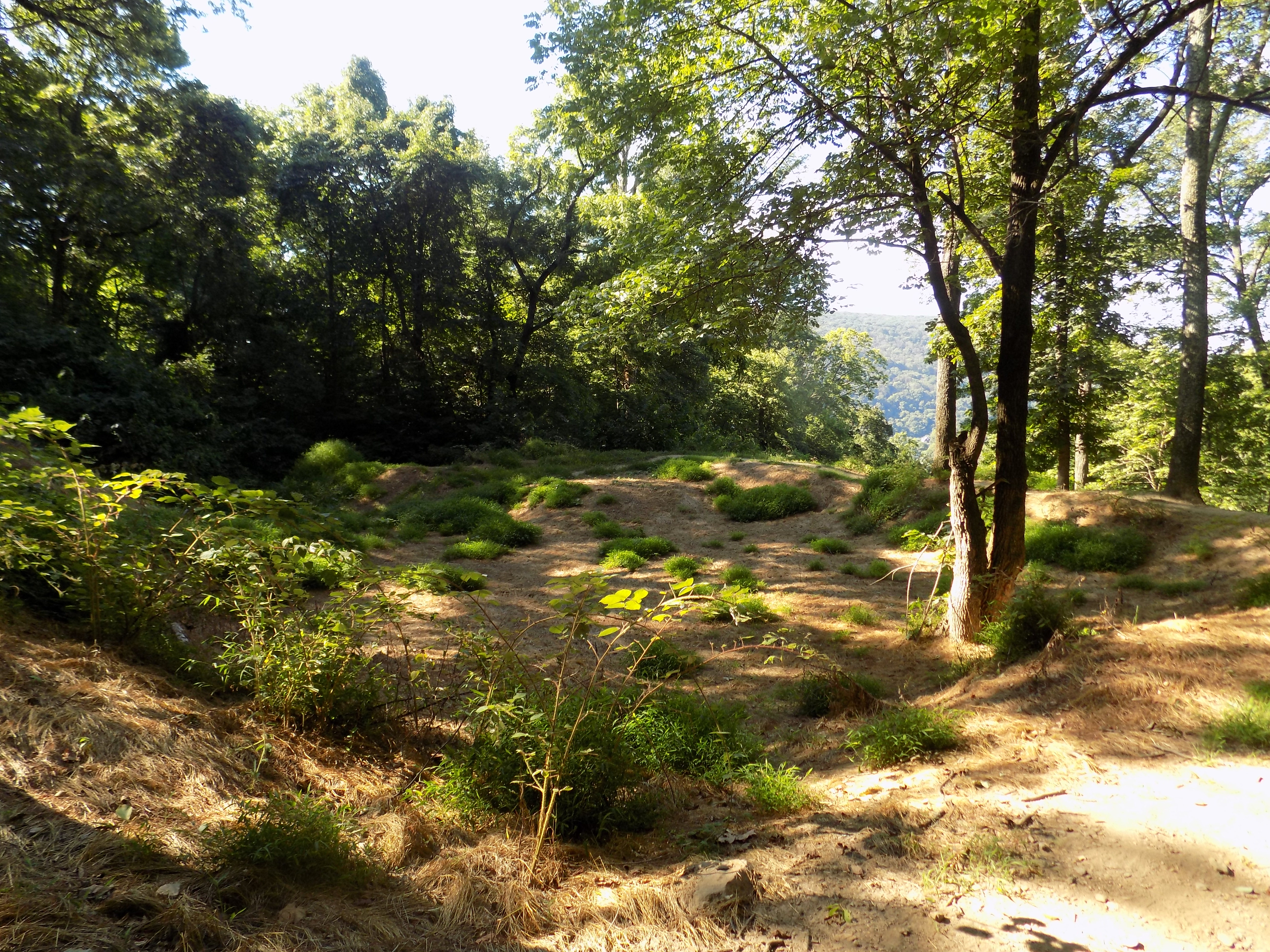
Don’t miss the naval battery and earthwork ruins, located just off the Overlook Cliff Trail. After Jackson captured Harpers Ferry during the Antietam Campaign, Union commanders decided to move in the big guns to prevent another surprise. They actually hauled two 9-in Dahlgren naval guns and one 50-pounder cannon up to this location to cover the town. The fort was built in the summer of 1863.
The Overlook Cliff Trail will continue up-hill, and then welcome sight! A marked cut-off leading downhill to the actual overlook point. Follow this trail, down and take some time to enjoy the view.
(If you are very ambitious and want more exercise, you could hike the Stone Fort Trail which leads to the Civil War fortifications at the very top of Maryland Heights. There’s another fort and more history up there. You’ll have to tell me about that trail – I didn’t have time to climb all the way and decided to be content with the overlook.)

Did this hike , it was strenous.
Hope you enjoyed the view though. I actually thought about quitting halfway up, but decided to press on. It was so worth it!
Are there any markers or did you use the trail map to find the locations such as the naval battery? Great pictures.
There are a few markers. As I recall there was a very small wooden sign pointing the way to the naval battery. Definitely get a map though for more historical and trail details.