Preservation News: Cold Harbor
![]()
The Cold Harbor battlefield is the most popular of the many sites in the Richmond National Battlefield Park. This is probably due to several factors, which include the preserved earthworks (impressive) or the legend that 7,000 men were killed in 15 minutes (incorrect). In 1864, the battlefield extended roughly 7 miles. The frustrating thing for visitors and interpreters alike has been that that until recently only a small portion of the battlefield was preserved and open to the public. The Park contained a small visitor center and was positioned roughly at the center of the battlefield; however it was not the scene of the most vicious fighting that occurred on June 3, 1864. One thing the Park did have was a portion of the generally unappreciated action that took place on June 1.
The campaign that led to the slaughter at Cold Harbor encompassed many other sites in the area. As the Union army moved towards Richmond there were actions at Haw’s Shop, Enon Church, Totopotomoy Creek, Bethesda Church, Matadequin Creek and the Old Cold Harbor crossroads. All of these were outside of the Park’s jurisdiction, making effective interpretation challenging.
In the 1990’s Hanover County saved a parcel of land adjacent to and east of the Garthright House, situated along Cold Harbor Road. The County developed a park with a walking trail to commemorate the battle. The walk is recommended.
Things really began to change in 2006 when a developer, Andy Shields, and the Richmond National Battlefield Park teamed up to preserve the 18th Century Shelton House and surrounding 124 acres at Rural Plains in Hanover County. Itself an important piece of history, the house sits on part of the Totopotomoy Creek battlefield, and it witnessed the action in the area during the end of May. On the 29th Francis Barlow’s division arrived at the house, and Major General Winfield Scott Hancock made his headquarters under the eastern porch. On the 30th there was significant action, with the Federals suffering roughly 300 casualties. The house was hit by Confederate artillery fire approximately 50 times. Preservation efforts at the house are ongoing, but the battlefield is open to the public, and the house is open during the summer on weekends.
A short distance away is the site of the historic Pole Green Church, which was destroyed by Confederate artillery fire during the Totopotomoy Creek action. The site is preserved by a local group, and includes a small portion of the battlefield.
Around 2010, the Richmond Battlefield Association purchased a tract of land on Beulah Church Road. This was the site of action on June 1 and June 3, and was the beginning of spectacular growth near the original Cold Harbor site. Soon the Civil War Trust purchased a tract adjacent to the RBA land. The work of the RBA and CWT, combined with part of the original Park site, enables the story of the critical action on June 1 to be more clearly told. Now visitors can appreciate the significance of the actions of that day, which led directly to the more famous June 3 battle. It was also was the path of many of the VI and XVIII Corps attackers on the morning of June 3. As their comrades attacked across this field, wounded men streamed back across the blood-soaked field. This is truly sacred ground.
Earlier this year the Trust acquired a 51-acre tract that contained the fortification called Fletcher’s Redoubt. It is not yet open to the public, but when it is, the events that followed the June 3 battle will come more into focus. Visitors will better be able to understand the breadth of action at Cold Harbor. While many people previously might have only associated Cold Harbor with the June 3 battle, the armies remained in the filthy, sweltering and deadly trenches here for nearly two weeks, afraid to even raise their heads for fear of getting shot.
Now the Trust is acquiring 55 additional acres. One day in the future, visitors will be able to walk from the visitor center all the way to Beulah Church Road. They will have an enhanced appreciation for the June 1st actions and a better understanding why Grant chose to attack on June 3rd. They will be able to walk the ground of the men who attacked on June 1 and 3.
This is a great opportunity to save a critical piece of a major battlefield, and it is one we cannot afford to slip by. The story is too important not to be remembered. Please be sure to make a donation to the Trust to save this key piece of the Cold Harbor battlefield! Future generations will thank you.
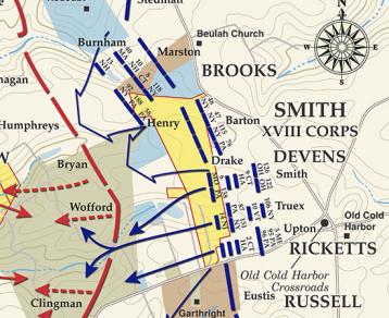
On this map, the yellow portions indicate the parcels the Trust is attempting to acquire. You can readily understand their significance. Other tracts include the blue one at the top of the page… this is the Fletcher’s Redoubt area. The other areas in blue are all CWT land. The brown piece labeled “Marston” is the Richmond National Battlefield piece. At the bottom of the map, the brown area is the land preserved by Hanover County. To the left, the large area (“Wofford”) is the original Richmond National Battlefield Park land. This map is particularly exciting because it shows how a battlefield can be preserved, piece-by-piece. Thanks to the Civil War Trust and the Richmond Battlefields Association, sites all over the Richmond area have been preserved during the past 20 years. It has been an amazing accomplishment!
Reblogged this on Practically Historical.