Antietam’s Lower Field Revisited Part I: The Neglected Southern Portion of Antietam
As a major battle of the war, Antietam is one of the most studied, discussed, and debated engagements of the conflict. Attention is usually focused on the northern areas of the battlefield, where fighting began and the most casualties occurred. The bulk of the day’s combat happened here where the largest portion of the armies fought. The upper area also has famous landmarks like the West Woods, North Woods, Cornfield, Sunken Road, and Dunker Church. The southern area of the battlefield is the most neglected, both historically and in modern studies.
This lower area of the Antietam battlefield near Burnside’s Bridge has long been overlooked: by contemporary historians, by journalists, photographers like Alexander Gardner, and even by the creators of the battlefield park itself. It did not involve nearly the numbers of troops or commanders that the northern and central portions of the battlefield did. Nor were some of the more famous personalities present here: Lee, Longstreet, Jackson, Hooker, and McClellan all were involved or supervised the fighting to the north. Some of the most famous units in both armies: the Iron Brigade, the Texas Brigade, the Irish Brigade, the Stonewall Brigade, fought in upper part of the battle.
In fact, the Union troops that fought on the southern portion of the battlefield were newcomers to the Army of the Potomac: the Ninth Corps. They had joined the army in time for the battle of Second Manassas and thus did not have a long association with it as some of the other corps did.
The overshadowing of the southern portion began in the days after the fighting ended. In the battle’s aftermath photographer Alexander Gardner spent most of his time taking his dramatic photos in the more famous northern areas, and by the time he reached the southern end of the field most of the dead had been removed. While he took many images of Burnside’s Bridge, there were no other major landmarks natural features that saw heavy fighting or captured the public’s imagination as those sites to the north. Gardner took no images of the areas where fighting occurred in the afternoon after the bridge’s capture.
In addition, while the upper area has been well preserved and the park includes the most significant areas of fighting, that is not the case with the lower area. Preserved land is important, for it affects what we can see and access, and therefore what we can more easily study.
Established by the War Department in 1890, the National Park Service acquired the Antietam battlefield in 1933. South of the Boonsboro Pike where the Ninth Corps fought, only a thin strip of land, following property lines, was acquired for a tour route. Along this line veterans placed monuments and the War Department installed metal plaques. The land where the actual fighting took place was not preserved but could be viewed from the tour road. This approach, soon called the “Antietam Plan” would be replicated in other battlefield parks to avoid costly and controversial land acquisition, but still provide access to view the terrain for visitors.
The War Department placed metal plaques, as it did at other military parks, to note the position and actions of various units. Through the 1890s and early 1900s, Union veterans placed monuments to their regiments and batteries, often along the tour road, more rarely on private land where they actually fought.
The area between the Boonsboro Pike and the sharp bend in Antietam Creek downstream from the Burnside Bridge conveniently encloses the lower area of the battlefield. A narrow access path led to the 9th New York (Hawkins’ Zouaves) monument, but otherwise nearly the entire area was not preserved and inaccessible. The National Park appreciated the significance of this area, and in the early 2000s the park was able to acquire the land south of the 9th New York monument, saving a large chunk of battlefield land. In 2003 the area between the tour road and the bridge was acquired, preserving even more critical areas of fighting at the Otto and Sherrick farm sites.
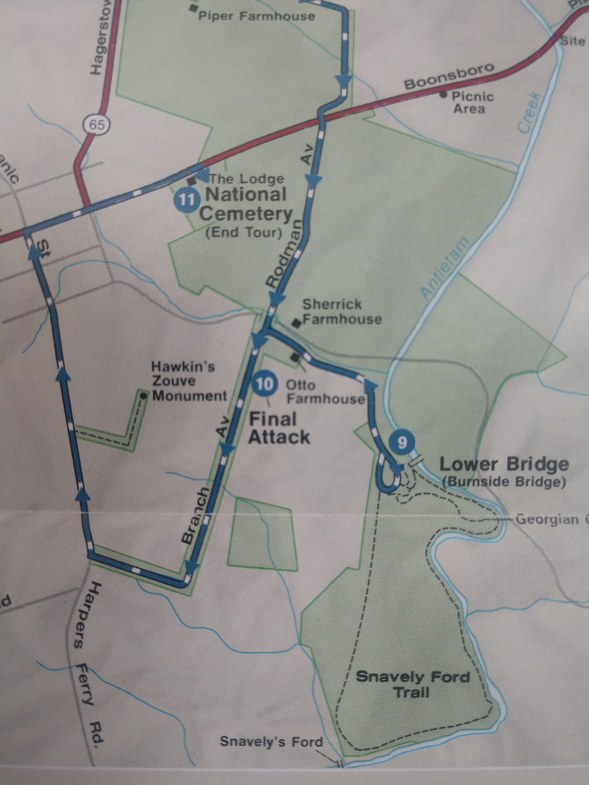


The park staff at Antietam should get credit for increased land preservation through the 2000s and developing innovative ways for visitors to access and appreciate the unspoiled landscape. Known as Discovery Trails, new paths take visitors into the landscape, away from tour roads and parking lots, allowing them to follow the action and understand the battle as the soldiers did with as minimal modern intrusion as possible. These trails have minimal signage and are often simply a mowed path, and carefully placed so as to bring visitors to key areas.
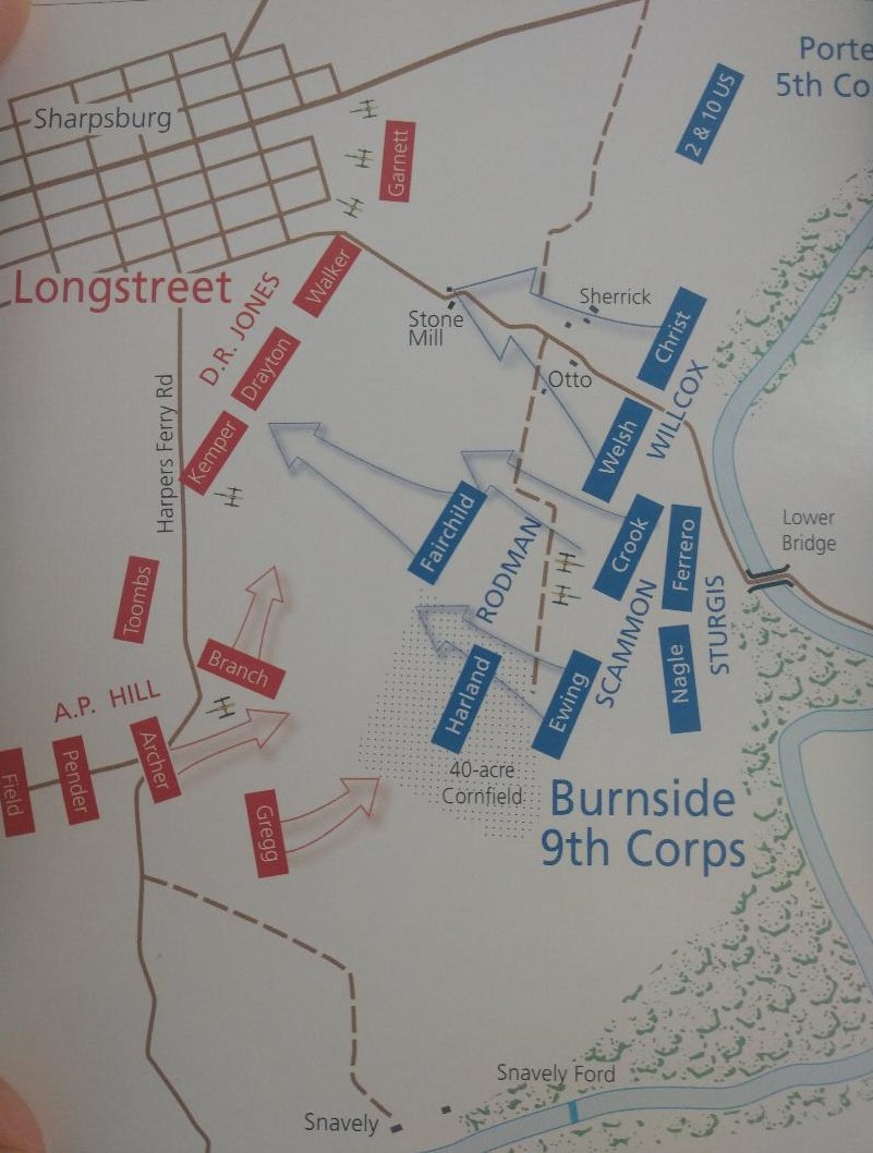
Despite more land preserved here, the battlefield area between the 9th New York monument and Burnside Bridge Road (north of the monument) is not. Two Union brigades advanced against three Confederate brigades here. Over this ground Union forces suffered about 400 casualties, the Confederates about 500. It is the last major part of this lower battlefield not protected.
This part of the field is the only area where the Confederates used Antietam Creek as a barrier, and thus the only part where Union troops had to force their way across. Almost a separate area, Ninth Corps fought alone, without any direct support, the only place where a Union corps fought unassisted at Antietam. It was almost a separate battle from the main engagement.
Our general understanding is also oversimplified by focusing on Burnside’s Bridge and A.P. Hill’s counterattack. The Union struggle to capture the Rohrbach Bridge and accompanying inept leadership is certainly a crucial part of the story. Hill’s arrival in the nick of time and at the right place is a made-for-Hollywood moment. Yet in between were important actions that have been largely neglected, such as the advance of General Isaac Rodman’s and General Orlando Wilcox’s divisions- late day drives that nearly succeeded.

The disjointed Union advance after capturing the bridge was crucial to how events unfolded that afternoon. How and why it occurred, and how it affected the rest of the engagement are crucial to the engagement’s outcome.
The details of the flow of combat through the Cornfield and into the West Woods, as well and the advance on the Sunken Road, are well documented in Antietam studies. Not so the combat on Otto’s ridge, the 40 acre cornfield, Sherrick’s orchard, and Otto’s farm lane. Again, many histories speak in general terms or paint broad brush strokes in describing these actions, yet intense fighting ensued across the slopes and fields below Sharpsburg and it deserves a more detailed look.
This is all not to say that the fighting in the southern area was of equal importance or scale to that above it, or that A.P. Hill’s attack was insignificant. Yet our study of Antietam seems unbalanced and perhaps it is time to take another look at this area and examine these questions in greater detail.
The battle of Antietam began at the upper end, and saw the most ferocious fighting at the Cornfield, West Woods, and nearby areas. From mid-morning until the midday, fighting shifted to the center at the Sunken Road. Then in the afternoon, the fighting intensified at the lower end of the battlefield, and the engagement reached its indecisive climax here.
The author thanks Kevin Pawlak for his advice and input.
I was able to hike this portion of the battlefield last summer and really enjoyed it!
In college I did a study of the Ninth Corps in the Maryland Campaign. I found this end of the field very interesting and deserving of more study. Even with the failures at the bridge, the Ninth came very very close to overall victory. Thanks for doing this series.
An important reminder that significance does not always equate with number of casualties. Sometimes a maneuver, that produces no casualties, is the pivotal event, as in Grant’s move to Petersburg. Also, a discerning point for the shaping hand of memory and historiography. Intriguing intellectual history.
Thank you for alerting me to the new trails in the southern end. On my trip this summer, my first in twenty years, I will take advantage of the available vistas. Many people have reported that the flank CT regt. had rugged terrain. I look forward to the understanding their experience
I have walked quite a bit of the ground discussed here and am amazed by how difficult the fight would have been. The ridges are broad and steep. Hills attack slammed into the Federals creating confusion and a pull back. Imagining the fight on those steep rough hills is much better from those paths.
Thank you for focusing on this part of the engagement.
This is an incredibly beautiful area where you can see an almost pristine landscape showing it as it was in 1862. It lacks services and sufficient signs though, but with a little attention could be a national treasure. Purchasing the land involved in the attack by Hawkins’ Zouaves would help in the understanding of this segment of the battlefield, allow you to walk the path they fought, and experience this last great missed opportunity to end the war.