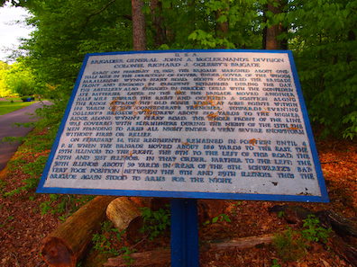
Forts: The War Department Tablets of Fort Donelson

Just in time for the 160th anniversary of the battle, Darryl R. Smith, owner of Walking With History tours, has released a new study, The War Department Tablets of Fort Donelson National Battlefield. Darryl admits, “the book is rather niche in scope,” but it provides the text to all the tablets, including those that are missing, and denotes where the existing tablets should be (some have been moved from their original spots).
I took a few minutes earlier this week to ask Darryl about his unique approach to looking at the battlefield.
CM: How did you get interested in Fort Donelson in the first place?
DS: While my focus is mostly on the Army of the Ohio/Cumberland, I enjoy all things Civil War. My first title on the Fort Henry and Donelson campaign was Benjamin Franklin Cooling’s wonderful book, Forts Henry and Donelson – The Keys to the Confederate Heartland (University of Tennessee Press, 1988). However, being a maps junkie, the maps in his book didn’t quite set the visual stage for me in terms of understanding the terrain.
In 2016, I decided to do a winter backpacking trip using the trails near Fort Henry as I wanted to hike the historic routes (such as the Telegraph Road) that Grant’s men utilized in their movements from Fort Henry to Fort Donelson. I spent a cold couple of days exploring the region, and then visited the national battlefield itself. I was hooked. Not certain why, except perhaps the ruralness of the region was refreshing compared to some other battlefields that are closer to urban sprawl. Perhaps this rural setting means that as Fort Donelson is not visited as often as it should be, which makes it feel like an “underdog” of an NPS battlefield. More Civil War buffs need to make the trip to Dover, Tennessee, and truly understand the importance of the Tennessee and Cumberland Rivers.
CM: We see War Department tablets on battlefields all over the country. What makes them such an important tool for understanding a battlefield?
DS: The War Department tablets are in many cases the first efforts at comprehensive interpretation as they provide the “this happened here” story. Using the tablets in conjunction with modern day interpretive panels gives the battlefield tramper a more complete story. To be honest, until delving deeply into tablets at Fort Donelson, I never gave them the interest I should have in the past, but now look at the tablets in a different light.
CM: How are the tablets at Fort Donelson unique compared to tablets at other battlefields?
DS: As Fort Donelson National Battlefield is a second-generation park, by the time the park was established in the late 1920s and early 1930s, most of the veterans who served there were either dead or of such an age that they could not physically travel. Therefore, Fort Donelson does not have the impressive monumentation that blesses the first-generation parks. The monuments at the first-generation battlefields, for the most part, are located in the places where the veterans themselves said they should go. Without having these monuments at Fort Donelson, the War Department tablets serve not only as a first level of interpretation, they are also the connection we have to the end of the Civil War generation. I am not certain if they are unique, but they are an important part of the interpretation at Fort Donelson.
CM: What made you decide to focus in on the tablets as your own lens for looking at the battlefield?
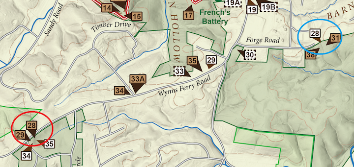
DS: In 2017, I was making my second trip to Fort Donelson within two years. On this trip, three of my Chickamauga buddies were in tow. As we hiked the trails and toured the field, we discussed how some of the tablets seemed to be misplaced as the information on some of the tablets did not at times match the terrain or the units being described. The following year, I made a return trip to Fort Donelson with the intention to research the War Department tablets and satisfy my own curiosity. With great assistance from the Fort Donelson staff, particularly NPS ranger Susan Hawkins, I spent a rainy morning going through the War Department tablets file. Maps, pictures, invoices, even a few inventory listings provided me with the evidence that indeed some of the tablets are currently placed in different locations and that several were missing. Obtaining the text for all the tablets, I decided to put together a guide that provides all the text as well as the original locations. I want to thank David Powell, Andy Papen, and Patrick McCormick for joining me on that trip in 2017 as that sparked the road to creating the guide.
CM: There were originally fifty-one tablets, but as you say, some have since been removed. Did you visit each one? If so, what was it like to “walk in the footsteps” with the tablets as your guide?
DS: I can say I have visited every existing tablet at least three times, even those that require a bit of hiking to get to. Even if I was not in a quest to locate, photograph, and understand each tablet, walking the trails along the Confederate outer works provides a clearer understanding of the terrain. And when one is hiking the trails along the Confederate out works, especially at Maney’s Battery location, there is a feeling of remoteness that allows the visitor to imagine what it might have been like in February 1862.
CM: Was there anything about this project that shed new light on the battle or battlefield for you?
DS: Several items actually come to mind. Already mentioned are the moved tablets and what their impact might be if they were in their proper locations. Another item is the lack of preserved battlefield ground beyond the fort and the Confederate outer works. This has been rectified somewhat in recent years through the efforts of the American Battlefield Trust, but why those in the 1920s & 30s did not make a more strident effort to save the land that involved the heaviest fighting (the Confederate “breakout” attempt on February 15th) is a frustration to those of us wanting the same sort of preservation the rest of the park enjoys. And while perhaps not new light, we all know the story of the incompetence of the Confederate commanders on the ground at Fort Donelson, and the lost opportunity they did have for a few hours to breakout. I am hopeful that the park will install interpretation and a trail network on this recently acquired property that will provide more emphasis on February 15, 1862.
CM: Anything I haven’t asked you that I should have?
DS: I would suggest several titles for studying the campaign in some details. I have already mentioned Dr. Cooling’s book above, but the definitive title is Timothy Smith’s more recent effort, Grant Invades Tennessee – The 1862 Battles for Forts Henry and Donelson (University Press of Kansas, 2016). [CM: Winner of the 2017 ECW Book Award, too!] Kendall Gott’s Where the South Lost the War – An Analysis of the Fort Henry-Fort Donelson Campaign, February 1862 (Stackpole, 2011) is a focus on command decisions, and falls in operational scale between Cooling and Smith. For those wanting to really understand the campaign, I believe a reading of all three is in order. And a bit of self-promotion, but having a copy of the War Department tablets guide might be useful while touring the area.
Enjoed the Q&A concerning reasons why this book about the tablets/wayside markers was created and hope this could become a series for other parks!
Thank you! It was an enjoyable project! I had given thought to doing one on Chickamauga, then realized that would be one massive undertaking!