McIlvaine’s Hotel: A Landmark on the Road to Gettysburg
For those who over the years have traveled to Gettysburg with some regularity, I’m sure that each of us have some landmarks that once passed let us know we really are on the way to Gettysburg. For myself, there’s still a sense of anticipation each time I take the Breezewood exit off the Pennsylvania Turnpike. Not so much for the little oasis that is Breezewood, but that the 65 miles along the Lincoln Highway between there and Gettysburg makes for an idyllic drive, especially in the summer and fall with the many roadside orchards and farm stands.
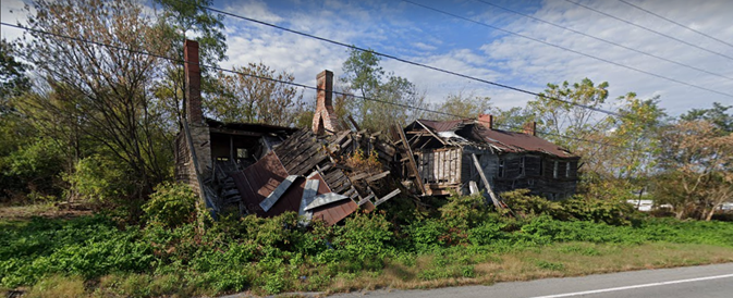
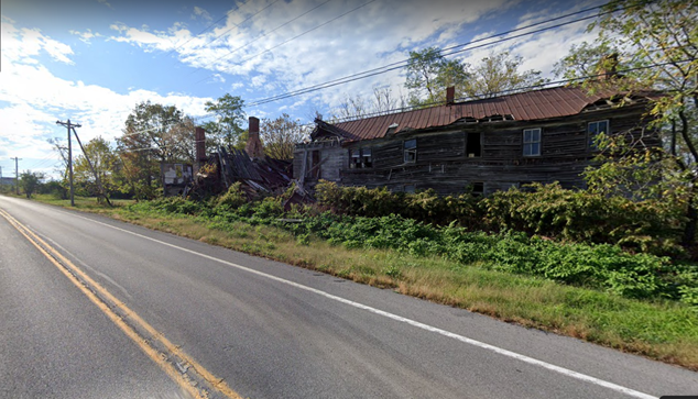
More than the exit itself, the first real landmark for me is just about 5 miles outside Breezewood as you head east on the Lincoln Highway towards Gettysburg. At this point Route 30 and the interminable turnpike, running roughly parallel from Breezewood, finally diverge. Here (GPS: 40.01881, -78.18873), if you carefully steal a glimpse to your left, you can see the ruins of the former McIlvaine Hotel. Later known as the Mountain House, it doesn’t take much imagination to see that in its day this expansive building must have really been something special.
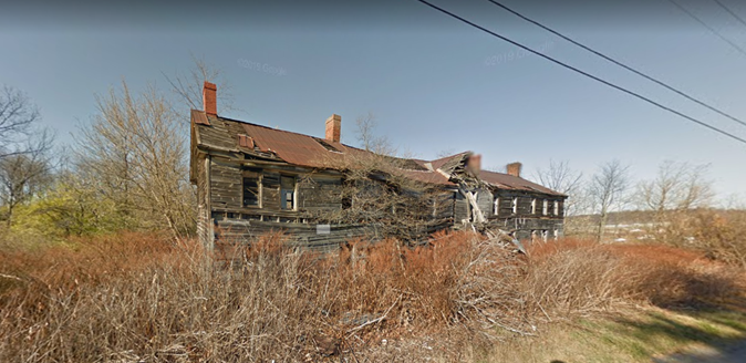
Obviously abandoned for many decades, only in recent years has the left side of the building partially collapsed, no doubt a testament to its sturdy log construction (visible in the collapsed section). We don’t build things today that could withstand decades of neglect. Yet even in disrepair these buildings bear evidence to the pride and quality of 19th century vernacular architecture and craftsmanship.
Strange place for a road trip benchmark, eh? Don’t judge me…I’m as much of an old building aficionado as I am a battlefield junkie, and after recently passing the crumbling house I thought I’d see what I could turn up. And it just so happens that this remote corner of Fulton County, some 90 minutes west of Gettysburg, has its own ties to the Gettysburg Campaign.
McIlvaine’s Hotel sits on the eastern side of a prominence known as Ray’s Hill, a ridgeline running west of Sideling Hill and east of Tussey Mountain. While I haven’t found an exact construction date, sources indicate the house was built as early as 1780 astride Forbes Road. Constructed by Brigadier General John Forbes during the French and Indian War, the road served to link Carlisle and far off Fort Duquesne (Pittsburgh). Early owners of the property include the McAffey, Gray, and Sproat families before John McIlvaine purchased the property, then serving as a tavern, and some 500 acres of land in 1858.
McIlvaine opened the tavern into a hotel, one account suggesting that McIlvaine’s Hotel became “the most noted drover stand on the road” between Bedford and Chambersburg. [1] A large barn was constructed in 1862, and the many outbuildings situated around the property were “so numerous as to give the place the appearance of a small village.”[2]
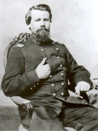
While Fulton County escaped incursion during J.E.B. Stuart’s Pennsylvania Raid in October 1862, by the summer of 1863 the war was coming precariously close to the neighborhood of Ray’s Hill. Following the disastrous Battle of Second Winchester (June 13 – 15, 1862), Federal troops flooded north through Maryland and into Pennsylvania. Major General Robert H. Milroy, who had commanded the Federal garrison at Winchester, attempted to consolidate his scattered command at Bloody Run, Pennsylvania (present day Everett).
With Milroy quickly summoned for a court of inquiry to explain the recent disaster at Winchester, command of the demoralized troops at Bloody Run devolved to Col. Lewis B. Pierce of the 12th Pennsylvania Cavalry. From his headquarters in Harrisburg, Maj. Gen. Darius N. Couch, commanding the Department of the Susquehanna, directed Pierce to “hold in check the rebels, and cover the country. Harass them, and do not be cut off.”[3] By June 30 Pierce’s command at Bloody Run had swelled to nearly 3,000 troops.
Confederate troopers of the 16th Virginia Cavalry briefly occupied McConnellsburg, the seat of Fulton County, during the early hours of June 19. A substantially larger body of Confederate troops – some 2,500 infantry, cavalry, and artillery – returned on June 24, under the command of Col. George H. “Maryland” Steuart.
Opposing Steuart’s Confederates at McConnellsburg were two companies of local militia and a handful of troops of the 12th Pennsylvania Cavalry. Though the militia had been “bushwhacking the rebels with great success,” one local resident judged by the size of the column and the number of wagons that the Confederates “intend to occupy the valley for a long time.”[4] While the militia scattered into the woods, ten troopers of the 12th Pennsylvania were captured by Steuart’s men.
As the Confederates entered McConnellsburg from the east, telegrapher Thomas F. Sloan closed his station and slipped out of town with his telegraph key headed west. After what he described as “a perilous journey” of some fourteen miles through the mountains, Sloan emerged at Ray’s Hill and established a remote telegraph office at McIlvaine’s Hotel.[5] In June 1863 the telegraph in south-central Pennsylvania served as a critical lifeline to keep both Harrisburg and Washington apprised of what direction the Confederate invasion had ebbed and flowed. From McIlvaine’s Hotel, Sloan reported the fighting at McConnellsburg to the outside world.
On June 26, after receiving word that the Confederates had departed, Sloan returned to McConnellsburg and reopened his office. Two days later, Col. Pierce at Bloody Run received “reliable information” that Confederate Gen. John D. Imboden and some 6,000 men had occupied the area around McIlvaine’s Hotel.[6] This supposed force – outnumbering his command by more than two to one – unnerved Pierce, who recalled Gen. Couch’s cautions to not risk being cut off. Pierce pledged to occupy the mountain passes between Bloody Run and Bedford and “hold him [Imboden] in check as long as possible.”[7]
The following morning Pierce ordered Co. A of the 1st New York (Lincoln) Cavalry to ride east towards McIlvaine’s Hotel and scout for Imboden’s command. Captain Abram Jones and his thirty-one men found no Confederates at the hotel, instead finding a portion of the 12th Pennsylvania who had cleared out of McConnellsburg on June 24. Jones continued east, hoping to locate the captured men from the 12th Pennsylvania, and reached McConnellsburg on the morning of June 29.
Joined by fifty local militiamen, Jones was soon warned of a company of approaching Confederate cavalry (fifty men of the 18th Virginia Cavalry). Ordering his men to “get on your horses and get to your places…I’ll fight them,” Jones and his men killed two and captured nearly three dozen Confederate cavalrymen in a running skirmish through McConnellsburg.[8] The captured Confederates were conveyed out of town to Bloody Run, passing the curious boarders and residents at McIlvaine’s Hotel – the only Confederates seen at Ray’s Hill during the Gettysburg Campaign.
Following the Civil War, telegrapher Thomas F. Sloan returned to McIlvaine’s and reopened a Western Union telegraph office from the hotel. After the turn of the century the Mountain House was purchased by ex-congressman Joseph E. Thropp (R-PA) and was advertised as a “delightful summer resort” where visitors could escape from the hot summer weather and sulfurous atmosphere of urban areas.[9] It is unclear when the building was abandoned, though it’s obvious to have been many decades ago.

A tenuous connection to the Gettysburg Campaign? Perhaps, but for myself it will remain a landmark to let me know I’m really on my way to Gettysburg. What’s your landmark?
**Author’s Note: I passed the property in early September 2022 and found only a vacant lot. Apparently sometime between March and August 2022, McIlVaine’s Hotel was razed. Time to look for a new landmark on the road to Gettysburg…**
[1] Fulton County News, October 05, 1899
[2] ibid
[3] O.R. Series I, Vol. 27, Part 3, page 363
[4] Alexandria Gazette, June 26, 1863
[5] ibid
[6] O.R., Series I, Vol. 27, Part 3, page 390
[7] ibid
[8] Beach, William H. The First New York (Lincoln) Cavalry, From April 19, 1861, to July 7, 1865. New York, NY: Lincoln Cavalry Association. 1902. 259-260
[9] Fulton County News, June 25, 1908
Thanks for this, I have traveled that road many times and will enjoy finding this
Thanks, Joe!
thanks Jon-Erik … i love these little nuggets you and your compadres come up with — they’re terrific …. and i had no idea ANV cav was so far west.
Thanks, Mark. I’m nothing if not a fan of the obscure!
Great article! We hear about Pickett’s charge and Little Round Top bayonet charge and all the epic stuff, but this type of action happened all over the place and its nice to see McIlvaine’s Hotel get its 15 minutes of fame. Pennsylvania winters are rough, sad to see it edge into posterity. I’ve become partial to two landmarks on the route to big G. I like the approach from the south in Maryland going up Mapleview Road and Ritchie Road. My landmark is on your right, the beautiful mountains. You can see how well they screened Lee’s advance for miles. From the Eastern side of them you wouldn’t see dust clouds or the sun shimmering off Confederate guns, you wouldn’t hear marching, orders barked or horses snorts. I also like the store in Cashtown where I’ve read that Heth obtained a hat, the hat being a little big, he put a folded paper shim in it to fit, and that shim ended up helping to stop a bullet, possibly saving the guy’s life. The one-time store, circa 1227 Old Rte 30, has that architecture particular to the period, not super fancy, not gingerbready, but old time with big windows facing south.
Thanks, Henry! Lately I’ve also been taking MD66 up to 491 past Fort Ritchie and Blue Ridge Summit and through Fairfield. I like to stop at Rock Top Book Shop in Cashtown.
I love the “Home of Nellie Fox” sign in St. Thomas on Rte 30. I marvel at the close proximity of the homes in St Thomas to Rte 30. I agree that the views on Rte 30 can be spectacular when driving east.
Thanks! St. Thomas is a cool little down, but they lost a big chunk of main street with their recent firehouse.