The Story of the Mississippi as Told From Fort Hill
Fort Hill stares down from the Vicksburg bluffs like a scowling giant. Try me, it invites. The fort anchored the left flank of the Confederate line encircling the city, and it was so formidable, Federals never made an attempt against it.
The Mississippi River itself once flowed past this point, making a sharp U-turn below this stretch of bluffs. Ships coming from upriver trying to navigate that turn had to slow down. For the Union navy, this posed a special challenge because, once slowed, after they made the bend, they had to work back up to speed. In the interim, the boats were easy targets for Confederate batteries along the river and on the bluffs.
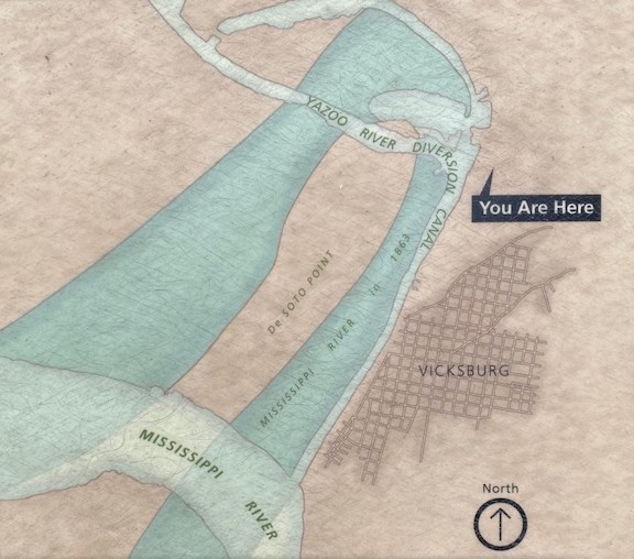
Grant tried to circumvent this hairpin bend by digging a canal across the peninsula formed by the bend in the river. This finger of land was called DeSoto Point, and by cutting across its base, Grant could provide a river route that made Vicksburg obsolete. He could not pull off the project. (Read more here.)
Later in the spring, Grant considered other engineering schemes to divert the course of the river to bypass Vicksburg—to no avail—but several years later, Mother Nature did it in a blink. In 1876, a massive storm led to flooding that changed the course of the Mississippi. After the floods, the Mississippi flowed to the south of Vicksburg, leaving the “Gibraltar of the South” without a waterfront.
In 1902, the Army Corps of Engineers, diverted the nearby Yazoo River so that it would flow into the Mississippi’s former river bed. This new waterway—Yazoo River Diversion Canal—brought the river back to Vicksburg (sort of).
Fort Hill offers an extraordinary position from which to see the traces of this massive geological story. Below, the Yazoo River Diversion Canal flows in from the northwest, bending in a sharp right angle at the base of the bluffs to flow southwest toward the Mississippi. The canal joins the great river just south of Vicksburg.
But most fascinating to me as I look down on the waterway is the outline of the former bend in the river. I can still see the old trace of the great river bowing in a big watery arc. It is literally diversion-canal backwater now, but it was once the mighty Mississippi.
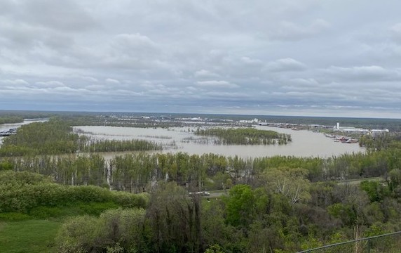
Yet this backwater is hardly backwater, at least in the out-of-the-way sense. Traffic from Mississippi comes up the canal, past Vicksburg, to a large inland port that grows, scabrous, on the northern bank of the bow. This is the busy port of Vicksburg, humming with modern industry the way the city’s port once hummed.
This story, writ large across the land- and water-scape beneath me, reminds me how vast and complex the Vicksburg campaign really is. The Fort Hill viewshed speaks volumes about a river that isn’t even there.
Always wanted a post on this transformation! Thank you. And for using the word “scabrous”, one of those medieval, “Game of Thrones” type of words!
Similar situation at Grand Gulf and Pt Hudson where river has moved to the west.
When I first read that “the fort anchored the left flank of the Confederate line,” I was confused. Surely you meant the right flank. Fort Hill is the right flank of the line of batteries extending down the riverfront and defending the city from attack by water to the west. Then I realized you were speaking of the circle of land fortifications defending the city from the east, for which Fort Hill is the left flank. Shows the difference between an army and a navy perspective. Since your piece focuses on the river, I’ll consider it the right flank.
photos really help to supplement the NPS map