In the Low Places: Looking for Medical Locations on Historic Battlefields
Historic battlefields are typically interpreted and visited with the idea of understanding the military action that unfolded there. Strategy and tactics, the “art of war,” and military decisions that resulted in victories or defeats tend to be the focus. And rightfully so, since these were the main events that draw people “to see where and by whom great things were suffered and done for them” (Chamberlain, 1889). Learning to read terrain with the historic weaponry in mind is a fascinating exercise, and yet it ties back to placing cannons or deploying troops for maximum offense or defense, depending on objectives. All too often the most crucial geographic features became the highly contested, high casualty areas. Battles at their most basic, brutal reality meant killing and trying to kill effectively to secure a particular outcome on the fighting ground…a sobering thought.
Enter a reverse way to study the now-silent battlefields: terrain to save lives. During or after a fight, how did a battlefield’s land aid or hinder the care of the wounded? Where was a field hospital placed? What roads would hasten the ambulance evacuations? Where to place a dressing station, closer to the regiment or brigade’s fighting line? What features in the landscape might have provided natural shelter or protection for the injured and their caregivers? Which man-made structures provided protection or which were too close to the battle to be officially seized for medical purposes while the shooting was still happening? When did the low ground become life-savingly valuable instead of the high ground?
This type of battlefield study and interpretation still requires a strong military knowledge for understanding battle lines, logistics, and weaponry ranges. Primary sources often lend clues to the medical story, too. From soldiers’ writings to official reports, civilian accounts or damage claims, and specific medial records, sometimes it is possible to pinpoint a place and connect it to its Civil War medical history. This allows a merciful theme to emerge from the bloody landscape and invites the study of how lives were saved during and after the shooting.
Here are a few Eastern Theater examples:
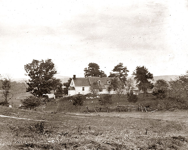
On September 17, 1862, the Confederate Army of Northern Virginia and the Union Army of the Potomac engaged in the single bloodiest day in United States history along the Antietam Creek and near the village of Sharpsburg, Maryland. Nestled in the rolling terrain, about a mile and half from the town sat William and Margaret Roulette’s Farm. While his neighbor Samuel Mumma’s farm went up in flames since its positioned offered cover for sharpshooters, William Roulette’s house, barn, and outbuildings escaped permanent damage. Instead, Union soldiers surged around and through his property, heading south in their attack route toward the Sunken Road. Roulette cheered them on, rushing out of his cellar shelter to shout: “Give it to ‘em! Drive ‘em! Take anything on my place, only drive ‘em!” Situated at intersecting farm lanes, Roulette’s farm became a key location for ambulance wagons to take wounded men to the larger field hospitals several miles north, away from the battle lines. The farm itself was a medical location, and 700 soldiers were buried on the property—both a testament to its proximity to the battle for the Sunken Road and for the gathering of wounded. After the battle, William Roulette did not receive his compensation claim for $3,500 in damages to his property, but he did receive $371 since his home and buildings had been used as a hospital. Now, standing at the intersection of farm lanes, most thoughts and tour interpretations weave the accounts of Union troops attacking toward the infamous Sunken Road. However, standing in the still-dirt roads offers a chance to look back toward the Union rear lines and consider the journey of ambulance drivers. The rush and pull of the horses to reach this location in the aftermath of battle, to use these roads to hurry injured men back to the larger hospitals in hopes of saving their lives.
At the battle of Fredericksburg in December 1862, Union wounded were pinned down—sometimes for several days—in the fields in front of Marye’s Heights. Confederate artillery crossfire covered the field, and Confederate infantry watched for movements to target. For some wounded Union soldiers, a swale in the open ground became their salvation. The depression gave them enough cover and increased their chances of living to get medical help from comrades or crawl toward town in hopes of darkness hiding their movements toward the hastily established hospitals in town. The Rappahannock River itself became part of the battlefield and medical history at Fredericksburg. Militarily, the focus centers on the riverine crossings and laying of the pontoon bridges on December 11. However, following the heaviest day of fighting on December 13, an evacuation pattern was established for the ambulance wagons: roll across pontoon bridges at the Middle Crossing (lower end of town), drive through the streets of Fredericksburg to pick up wounded from the hastily converted hospital buildings, then recross the river at the Upper Crossing, taking the wounded back to the Union’s side of the river and to more permanently established hospitals.
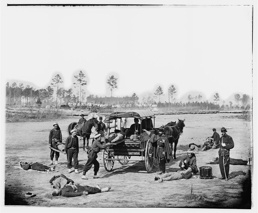
Gettysburg is likely the best (published) documented battlefield for matching medical accounts to the land, and numerous field hospital buildings at the surrounding farms still stand within the miles behind the battlelines and marked. While field hospital locations can often be identified on historic battlefields, it can be more challenging to figure out the position of dressing stations. The Letterman System, instituted for Union Army of the Potomac by Dr. Jonathan Letterman and later expanded and adopted, focused on moving a wounded soldier from battlefield to home as efficiently as possible. Ideally, a wounded soldier received a quick bandaging and assessment of his wound at a dressing station near the battle line, then he would be evacuated by ambulance several miles to a field hospital. There, his wound would be examined and he would be triaged, if an operation was needed to give him best survival chances it would usually take place at the field hospital. Next, the wounded soldier would be evacuated to a General Hospital, ideally making the trip by railroad or ambulance. At the General Hospital, he received more specific wound care or operations an usually stayed until able to return to his unit or until sent home on medical leave. Since field hospitals near battlefields were often established in structures and/or near still recognizable landmarks, they are often easier to identify. Dressing stations were closer to the fighting lines, maybe along a road for ambulance access, and ideally tucked somewhere that offered a little protection. While primary sources sometimes mention a dressing station somewhere in the immediate rear, it’s often too vague to pinpoint exactly locations.
However, at Gettysburg battlefield, there is a veteran-marked dressing station location—a rare and valuable place to learn and to see terrain with life-saving intent. The 32nd Massachusetts Infantry plunged across the infamous Wheatfield and fought on Stony Ridge during the late afternoon and early evening of July 2, 1863. Their surgeon, Dr. Zabdiel Adams, followed and established a dressing station. Prior to the war, Adams had studied at Bowdoin College, Harvard, and in France. His first battlefield experience of the Civil War was at First Bull Run where he witnessed wounded dying they had no immediate medical care near the locations where they first fell. Two years later at Gettysburg, Adams found himself without orders to attend at the division’s field hospital in the rear, so he decided to accompany his regiment into the fight. He placed his dressing station so close to the 32nd Massachusetts battle lines that he had to move once or twice as the fighting shifted the lines. His most memorable location tucked on the reverse of Stony Ridge’s slope and sheltered by several massive boulders. Here, he worked to staunch bleeding and save lives while the battle still raged. In the 32nd Massachusetts an estimated 60 men fell wounded and probably walked or were carried to Adam’s care. Other wounded likely sought refuge and aid, too. Following his life-saving work close to the front lines, Adams reported to the division field hospital and operated non-stop for two days and three nights. He went temporarily blind after that overexertion and was discharged on July 7. Later, he recovered and returned to his medical duties in time to be wounded during the Battle of the Wilderness, captured by Confederates, and forced to treat his own wound, surviving the ordeal.
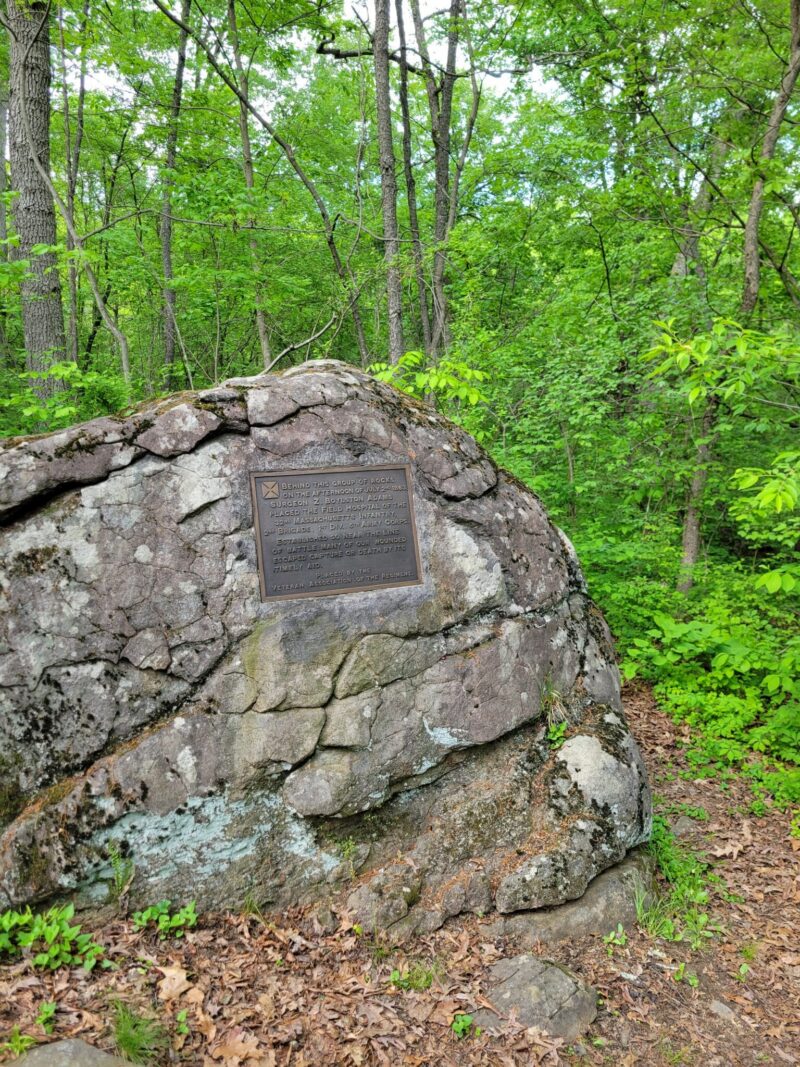
During the monument phase of Gettysburg battlefield’s history, the 32nd Massachusetts veterans placed their regimental monument in 1895. Then, the Veteran Association of the Regiment added a tablet to a large boulder, inscribed:
Behind this group of rocks on the afternoon of July 2nd, 1863, Surgeon Z. Boylston Adams placed the field hospital of the 32nd Massachusetts Infantry, 2nd Brigade, 1st Div., 5th Army Corps. Established so near the line of battle, many of our wounded escaped capture or death by its timely aid.
It is the only marked and monumented medical dressing station on Gettysburg battlefield, though certainly many others existed during and immediately after the battle. The location is also depicted in diorama at the National Museum of Civil War Medicine in Frederick, Maryland.
When thinking about Civil War battlefields through a medical lens and trying to see the life-saving lessons embedded in the landscape, I’ve found these considerations helpful for primary source research and the terrain:
- Are there nearby roads? Is there written evidence these roads became part of an ambulance evacuation route?
- Where is the battle line? Could wounded men move themselves or be aided by comrades to somewhere very close by that might provide shelter or water? (Sometimes primary sources include details – like “crawled X many yards and found Y and waited until the ambulances came.”)
- Where were the division field hospitals located? (Usually documented somewhere and usually several miles in the rear of the battle lines.)
- Look around, particularly in the rear of a fighting position. Where would it make sense to go if wounded? Where would it make sense to quickly set up a dressing station? (Not all were as close to the battle as Dr. Adams at Gettysburg.)
- What is known about the wounds of soldiers from this unit? Does the terrain and/or fighting tactics reveal something if there is a noticeable bodily location of injury? (Like – a lot of head wounds, a majority of leg wounds.)
Not all of these questions will be answerable. Some will be easier to track and clear to find with matching primary sources to the battlefield.
However, raising questions like these draws medical logistics into the study of the historic land. It also reminds that these “great battles” resulted in nearly unimaginable death and suffering and that the intense fight to save lives had its own way to use the terrain with a vastly different purpose. In the low ground, along dirt roads, and crouching low places, a different type of struggle unfolded. Soldiers looked for high ground and blazed away at their enemies, but in the lowly places merciful efforts staunched the blood of those bleeding in blue or gray uniforms.
Notes:
Accounts, references, and observations taken from medical tour notes for Gettysburg and Antietam, 2025-2026.
It brings to mind a historical query and a gruesome but necessary question:
First, does anyone have a map location for the field hospital of the 2nd South Carolina Rifles, one of Micah Jenkins’ regiments in the South Carolina Brigade, at the Battle of Glendale, 30 June 1862?
Second, field hospitals had to do horrifying work in countless battles – amputating hands, arms, feet, legs. These were always place in a pile and were buried together. Have the burial locations of the amputations been located? Marked with a memorial stone?
That would be interesting to find out, I’m sure there are burial pits with piles of bones from amputated limbs. Is technology out there to probe the ground and find them? I think so.
Meanwhile, at Pittsburg Landing, Tennessee the first field hospital of the Civil War is recorded: “established on Monday 7 April 1862 during the Battle of Shiloh by a surgeon of Buell’s Army of the Ohio, Captain Bernard J.D. Irwin. As the battle raged, Captain Irwin opened up a surgical station on the eastern side of the battlefield; within 24 hours this facility had expanded into a 300-bed surgical hospital, complete with an operating room, dispensary, office, kitchen, and medical officers’ dining room…” [from NPS “Tour Stop No.16 at Shiloh Battlefield.”]
Do you know if there is any record of the field hospitals used during the battles of South Mountain and Antietam? My daughter lives on a farm directly between these two related battlefields. It’s near the modern town of Boonesboro, Maryland, but during the Civl War their area was called Smoketown. Their barn (1840) and their home (1795) would have been there during the battles. I’ve seen references to a “hospital” in Smoketown, but no evidence of where it was.
Their farm neighborhood was overrun by both Rebels and Yankees during the Antietam, Gettysburg, and Monocacy campaigns. All three times the Rebs invaded the North, they came right through the Smoketown area.
Any ideas would be appreciated.