Reading Lee’s July 2 Battle Plan: A Map Worth Studying
ECW welcomes back guest author Cory M. Pfarr.
My favorite map from my two studies of Gen. James Longstreet’s role at Gettysburg is not one that depicts the battle itself. Created by the exceptionally talented cartographer Hal Jespersen from my research, it depicts something even more important: the battle as Robert E. Lee believed it would unfold.
Most Gettysburg maps show where units stood at a particular moment. Far fewer attempt to capture the assumptions, plans, and decisions that produced those movements. This map combines Confederate intentions, flawed intelligence, evolving plans, and the actual Federal position into a single image. Rather than simply illustrating troop movements, it illustrates decision-making.
For me, it is the kind of map I wish had existed when I first began studying Gettysburg years ago. The best way to appreciate it is simply to work through it one feature at a time.
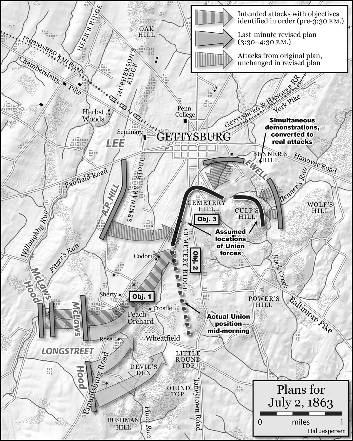
Start near Pitzer’s Schoolhouse at about 3:30 p.m. Notice the arrangement of Longstreet’s two divisions. Lafayette McLaws’s division stood in front, while John Bell Hood’s division remained directly behind it. Lee and Longstreet were urging McLaws to begin the attack almost immediately after reaching his jump-off position—even while Hood was still in McLaws’s rear.
That deployment tells us something important. At this point, Lee was still operating on the mistaken belief that no substantial Federal force occupied the ground south of Cemetery Hill. The map labels this assumption as the “Assumed locations of Union forces.” Based upon that understanding, the Confederate high command intended to launch a rapid, in-depth attack up the Emmitsburg Road with McLaws leading and Hood following in support. Instead of two divisions advancing side by side, they were initially organized in depth, allowing Hood’s brigades to reinforce McLaws as the attack progressed. The arrangement made sense, but only if Lee’s intelligence was accurate.
It wasn’t. As Confederate commanders recognized a substantial Federal force directly in front of them around the Sherfy peach orchard, occupied by Daniel Sickles’s advanced III Corps line, the attack had to be modified almost immediately. Hood’s division was shifted from behind McLaws to his right, transforming the assault from one designed with depth into one extending across a broader front. In the process, the division-level depth and immediate rearward support built into the original concept largely disappeared before the attack even began.
Perhaps just as striking is how quickly all of this occurred. The Confederates were modifying a major attack during roughly the final hour before stepping off. Military history rarely rewards plans that must be rewritten at the last minute, particularly when those revisions are driven by the realization that the enemy is somewhere commanders never expected him to be.
The map also reminds us that Longstreet’s attack was never intended to stand alone. Now look just to the north, where Richard H. Anderson’s division occupies the southern end of A. P. Hill’s Third Corps line. Lee envisioned Anderson continuing Longstreet’s attack northward once McLaws’s advance had progressed far enough to call Anderson’s brigades into action. Ultimately, however, only three of Anderson’s five brigades advanced. The attack Lee planned was therefore never fully executed.
Now shift your attention toward the center of the map and focus on Lee’s stated objectives. They are plainly labeled: the Sherfy peach orchard, Cemetery Ridge, and Cemetery Hill. Something is conspicuously absent: Little Round Top. That omission matters because it challenges one of the most enduring assumptions surrounding July 2.
For much of the twentieth century, one of the dominant interpretations of Gettysburg held that Lee identified Little Round Top as his principal objective on the southern end of the battlefield and that Longstreet’s delay cost the Confederates the opportunity to seize it while it remained lightly defended. Yet Lee’s own official after-action reports identify different objectives. The Peach Orchard came first, followed by Cemetery Ridge and Cemetery Hill. Little Round Top does not appear among them. That does not diminish Little Round Top’s tactical importance as the battle unfolded. Rather, it reminds us that historians should distinguish between what later became important and what commanders actually believed to be important while making their decisions.
Perhaps the most revealing feature of the map, however, is the comparison between the two Union lines. One depicts the Federal position Lee believed existed. The other shows the position actually in place by mid-morning. The difference helps explain why calls for a much earlier Confederate attack deserve closer scrutiny.
As early as approximately 8:30 a.m., Lee’s concept for the eventual attack called for McLaws to advance perpendicular to the Emmitsburg Road toward Cemetery Hill once the assault was launched. That orientation made perfect sense if the Federal army truly ended near Cemetery Hill, as Lee had been led to believe.
But it did not. By mid-morning, George G. Meade’s left flank already extended southward to just north of Little Round Top. Had Longstreet somehow launched the sweeping attack up the Emmitsburg Road that Lee envisioned during the morning hours, his columns likely would have crossed the front of multiple Federal corps while exposing their own right flank. At minimum, Confederate commanders would have been forced to substantially alter their attack plan. At worst, they would have advanced into circumstances fundamentally different from those Lee imagined.
The map therefore does more than answer the familiar question of when Longstreet attacked. It raises another question: What exactly would an earlier attack have looked like? Once the battlefield is viewed through the intelligence available to Lee on the morning of July 2, the longstanding assumption that an earlier attack would necessarily have produced a better outcome becomes much more difficult to sustain.
Finally, notice the notation reading, “Simultaneous demonstrations, converted into real attacks.” This represents another critical piece of Lee’s design. His July 2 plan depended upon concert of action across the battlefield. By the end of the 10 a.m. hour, Lee had settled upon the general outline of that plan. Longstreet would conduct the principal assault on the Confederate right. Anderson’s division would extend Longstreet’s attack northward once McLaws’s advance had progressed far enough to call Anderson’s brigades into action. On the left, Ewell would conduct simultaneous demonstrations that could be converted into full-scale attacks if opportunities developed. Working together, these operations were intended to prevent Meade from shifting troops from one threatened sector to another.
That coordination never fully materialized. Anderson attacked with only three of his five brigades, while no significant action developed on Ewell’s front until hours after Longstreet’s assault had already begun. The result was exactly what Lee hoped to avoid. Rather than remaining fixed in place, Meade continually reinforced his threatened left. Over the course of the afternoon, the approximately 15,800 Confederates engaged in the attack—including Anderson’s three participating brigades—ultimately faced more than 41,000 Federal soldiers as Meade shifted reinforcements across the battlefield, creating an approximate cumulative 2.5-to-1 numerical advantage.
That statistic, however, is really only the final consequence. The map tells us why it happened.
Good operational maps do more than simply record where armies moved. They help us understand what commanders believed, why they made the decisions they did, and how changing information reshaped those decisions in real time. For that reason, this remains my favorite map from my studies of General James Longstreet’s role at Gettysburg. In a single image, it captures not merely the movements of July 2, but the assumptions, flawed intelligence, evolving plans, and unrealized operations that shaped one of the Civil War’s most consequential afternoons.
Cory M. Pfarr works for the U.S. Government and is the author of Longstreet at Gettysburg: A Critical Reassessment (2019), Righting the Longstreet Record at Gettysburg (2023), and The Federal Signal Service at Antietam (2026), all published by McFarland. His essays have appeared in Gettysburg Magazine, North & South, Studies in Intelligence, and The Massachusetts Historical Review, and he has presented his research at the U.S. Army War College.
Bibliography:
Adelman, Garry, “Morning Hike of the Day 2 Battlefield | Gettysburg 163,” American Battlefield Trust, YouTube, 1:00:14, https://www.youtube.com/watch?v=m29w37fHcBM.
Campbell, Eric A., “So Much for Comrades in Arms,” https://www.historynet.com/much-comrades-arms.htm.
Hessler, James A. and Britt C. Isenberg, Gettysburg’s Peach Orchard: Longstreet, Sickles, and the Bloody Fight for the “Commanding Ground” Along the Emmitsburg Road, (El Dorado Hills, California: Savas Beatie, 2019).
Hessler, James A., Sickles at Gettysburg: The Controversial Civil War General Who Committed Murder, Abandoned Little Round Top, and Declared Himself the Hero of Gettysburg, (New York and California: Savas Beatie, 2009, 2015).
Kershaw, Joseph B., “Kershaw’s Brigade at Gettysburg,” in Battles and Leaders of the Civil War: The Tide Shifts, Vol. III, (New York: Castle Books).
Longstreet, James, From Manassas to Appomattox, (Philadelphia: J. B. Lippincott, 1896; Reprint, Cambridge, MA: Da Capo Press, 1992).
———. “Lee in Pennsylvania,” in Annals of the War, originally published in the Philadelphia Weekly Times; Reprint, Edison, New Jersey: The Blue & Grey Press, 1996).
———. “Lee’s Right Wing at Gettysburg,” in Battles and Leaders of the Civil War: The Tide Shifts, Vol. III, (New York: Castle Books).
McLaws, Lafayette, “Gettysburg,” in Southern Historical Society Papers, Vol. 7, edited by Robert Alonzo Brock, (Richmond, Virginia: Virginia Historical Society, 1879).
Pfarr, Cory M., Longstreet at Gettysburg: A Critical Reassessment, (Jefferson, North Carolina, McFarland & Company, Inc., Publishers, 2019).
———. “‘My Own Movement and On My Own Responsibility’: The Saga of Lafayette McLaws’s Commentary on Longstreet at Gettysburg,” in Gettysburg Magazine, Issue 70 (January 2024).
———. Righting the Longstreet Record at Gettysburg: Six Matters of Controversy and Confusion, (Jefferson, North Carolina, McFarland & Company, Inc., Publishers, 2023.)
———. “‘To Make a Demonstration, to the Letter’: Seven Distinct Maps of Longstreet’s Gettysburg Performance,” in Gettysburg Magazine, Issue 72 (January 2025).
Oeffinger, John C., ed., A Soldier’s General: The Civil War Letters of Major General Lafayette McLaws, (Chapel Hill and London: The University of North Carolina Press, 2002).
The War of the Rebellion: A Compilation of the Official Records of the Union and Confederate Armies, 128 vols., (Washington DC: Government Printing Office, 1880-1901), ser. 1, vol. 27, pt. 2.
Tucker, Glen, Lee and Longstreet at Gettysburg (Dayton, OH: Morningside Bookshop, 1982).


Excellent analysis and I appreciate your inclusion of the maps.
This is one of the best short-form discussions I’ve seen of command decisions in a battle. Great work, especially with the added maps!
Thoroughly enjoyed this article. Using maps in this manner is excellent. There should be more of this.
Great article. The myth of LRT needs to exposed. Longstreet opposed Lees plan and his delay allowed Sickles the Peach Orchard where Lee wanted artillery. Park ranger Troy Harmon wrote a detailed book “Lees Real Plan at Gettysburg “. An excellent read.
Wow, best map of 2 July i’ve seen … easy to see what Lee’s plan was and what really happened, and when … thanks!
A nice piece, and great maps. One thing to remember, though, is that when Lee made his brilliant en echelon plan late on the night of the 1st – which deserves to receive much more attention and credit – and when he gave Longstreet his orders, around 9 am on the 2nd – there was no substantial Federal force south of Cemetery Hill, and though it began to grow during the morning, it was still not that large or strongly in place. The key to July 2 was that Longstreet was supposed to attack as soon as possible, but he dillied and dallied, and had he gone in even by 11 am, the attack would have been a success. For remember – even though the attack did encounter enormous resistance, it did penetrate Cemetery Ridge – where the Federals had next to nothing to counter it. But Longstreet, with all his ridiculous counter-marching to conceal his troops, which resulted in nothing, because when he finally brought them to the field of battle they were immediately spotted, wasted 5 1/2 to 7 hours, by which time the Federal forces had grown, and had strengthened their position, and Sickles’ had made his great but eventually destructive error of advancing III Corps forward of the Federal line.
If one studies the history of the Army of Northern Virginia closely, one can see that after the Seven Days, Lee always had to closely manage Longstreet because he was always slow, was always late, and had a propensity for changing his superiors’ orders, which always resulted in disaster. On July 2nd Lee should have taken personal charge of the attack he designed, but he probably figured that even Longstreet would not take seven hours to march one mile across a field to attack a disorganized foe with an en echelon attack worthy of Napoleon at his best. It is Lee’s fault for not doing so, and for also failing to assume that as the morning, and then the afternoon, wore on with Longstreet failing to attack, Meade would be growing stronger, and thus he should have messaged Longstreet to either get on with it or call off the attack; it is Longstreet’s fault for fumbling yet another attack, much as he fumbled his assignment at Glendale. To further his failure, he later lied about what had transpired on this day, falsely claiming he had tried to talk Lee out of the attack; no such conversation, and no such demur, ever took place.