Shaping Chancellorsville: Change in the Landscape
Part nine in a series
By the mid-90s, the threat of development reached unprecedented levels because of exploding population growth in central Virginia. Additionally, the market value of land inflated well beyond the National Park Service’s legal or financial ability to purchase it. “We can’t do everything in the marketplace we need to do,” John Hennessey, Fredericksburg and Spotsylvania National Military Park’s (FSNMP) assistant superintendent, said at the time.[1]
In response, a new phenomenon developed: the establishment of private, not-for-profit battlefield preservation groups.
In November of 1996, Fredericksburg-area residents joined to create the Central Virginia Battlefields Trust (CVBT). Their first effort focused on a nine-acre parcel at the top of Willis Hill on the Fredericksburg Battlefield. The following autumn, CVBT turned its attention to Chancellorsville and a plot of land known as the Ashley Farm, located in a wedge of land between Route 3 and McLaws Drive. The property’s most historically significant feature is that it saw action on all three days of the main battle.
“This is in the heart of the Chancellorsville battlefield,” CVBT Treasurer Dr. Michael Stevens told the Fredericksburg Free Lance-Star. “We are representing not only the folks interested in Civil War preservation now, but we are representing the men who fought there.”[2]
CVBT first announced its intentions to acquire the property, which it dubbed “McLaws Wedge,” in a front-page article in its October 1997 newsletter:
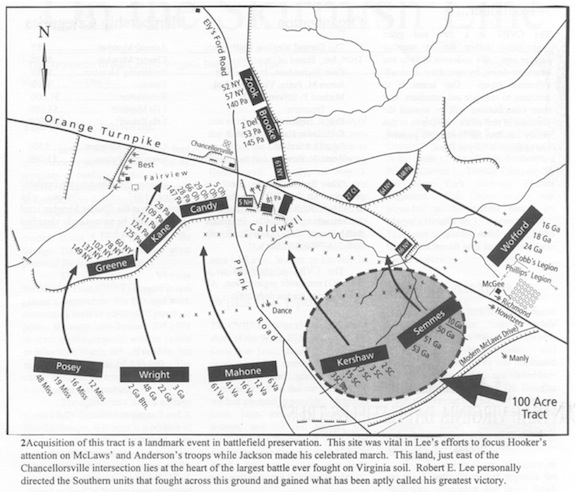
[T]his tract is a portion of the Chancellorsville battlefield that represents all three general phases of that battle. First, it was the scene of the initial Union advance, on May 1, 1863, as well as the Confederate counterthrust that same day. On May 2, a portion of the Confederate army held this area and fixed the Union army in place as Stonewall Jackson executed his daring flank march. Finally, on May 3, Southern troops attacked across this terrain as part of the climactic Confederate assaults that converged on the Chancellorsville crossroads and forced the Union army from the field.[3]
A more extensive description of the action on the property appeared on pages two and three of the newsletter. The narrative did not make mention of the Crackerbox Meeting or the Last Meeting, but it did spend several paragraphs talking about Jackson’s flank march, continually framing the action at McLaws Wedge with Jackson’s activities. “The Confederates in this area traded lives for the precious time Jackson needed to deploy on the distant Union flank,” the article said.[4]
Page three of the newsletter also featured a map of the property. The caption made particular mention of Jackson’s “celebrated march” and “what has been aptly called [Lee’s] greatest victory.”[5]
CVBT’s January 1998 newsletter featured additional site-specific interpretation about McLaws Wedge, including a full-page recollection from the regimental history of the 140th Pennsylvania Infantry, which received its baptism under fire on the ground. “May God forbid that the time should ever come when the evidences which yet remain should fail to recall in the generations following the reality and magnitude of the struggle and the costliness of the sacrifices by which the blessings of permanent peace, Union, and Liberty have been secured,” it concluded.[6] The Reconciliation theme of mutual sacrifice clearly stands out.
The McLaws Wedge property had a price tag of $450,000. In September, CVBT put down $100,000 toward the purchase price. By March 16, 1998, they were able to close on the property. CVBT then turned around and sold the land to the National Park Service for $420,000. On the surface, it appeared to be a $30,000 loss, but the net difference was money the NPS would not have been able to pay because of legal restrictions. The property, already surrounded by NPS-owned land and already within the Congressionally designated Park boundary, was easily absorbed into the Park.
Newspaper coverage of the sale summarized the battle thusly:
It was the place where Union Gen. Joseph Hooker lost the early advantage in the 10 days of fighting. It was also the scene of Confederate Gen. Robert E. Lee’s effort to hold a much larger Federal force in check while Gen. Thomas J. “Stonewall” Jackson’s troops made a devastating surprise attack on the Union flank farther west.
The battle culminated in one of Lee’s greatest victories.[7]
In May, CVBT hosted a re-enactment in conjunction with the 135th anniversary of the battle. As part of festivities, 173 re-enactors retraced the route of Jackson’s flank march. At that time, Jim Toler’s coverage for the newspaper characterized Chancellorsville as “Confederate Gen. Robert E. Lee’s most stunning victory,” which “propelled him to launch an invasion of the North that led to the Battle of Gettysburg.”[8] In a companion piece, Toler’s colleague, Kim Douglass, wrote, “Chancellorsville, considered Confederate Gen. Robert E. Lee’s greatest victory, is also where he lost his most valued commander, Lt. Gen. Thomas J. ‘Stonewall’ Jackson.”[9] The “greatest victory” and “martyrdom of Jackson” motifs both got play, as did the “Gettysburg” motif, but neither piece mentioned any of the specific events that happened at McLaws Wedge.
CVBT, in contrast, made a conscious effort during the land acquisition process to discuss the story of the property in both the broader context of the battle and in the site-specific context of the property itself.
However, interpretation of the site over time has continued to follow the trend CVBT established in its first newsletter: talking about the events at McLaws Wedge specifically in relation to either the “greatest victory” or “martyrdom of Jackson” stories. Take, for instance, a piece written in August 2005 by historian Bob Krick, which talks about Lee’s “matchless executive officer ‘Stonewall Jackson’” who “disappeared into the forests on an epic flank march clear around the enemy army” while “Lee spent all day to be pretending to be on the verge of launching an attack” sending entire regiments “advancing across the sloping fields of the Ashley Tract….”[10]
Even today, the first information CVBT provides on its website about McLaws Wedge, beyond ownership information, casts the story of the field in the context of the “martyrdom of Jackson” story:
General Lafayette McLaws’ Confederates skirmished across these fields, then covered by forests, on May 2, 1863, during the Battle of Chancellorsville. McLaws’ men pinned Major General Winfield Hancock’s division to its works, giving “Stonewall” Jackson time to turn the Union army’s right flank.[11]
Additional information on the page rounds out the story.
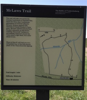
Shortly after acquiring it, the NPS established a one-mile, eight-stop walking trail across the property, which it rechristened “McLaws Field.” “Unique among Chancellorsville sites, this recently acquired tract of land saw action on each of the three major days of fighting…” says the trail brochure. While the brochure does mention Jackson’s attack, it does so only briefly, and emphasis remains firmly focused on the action at the wedge.[12] The sign at the head of the trail, however, firmly situates the action in relation to Jackson’s flank march: “McLaws’ spirited attacks fixed Hooker’s attention on this sector, enabling ‘Stonewall’ Jackson to successfully maneuver around the Union army’s right flank….”[13]
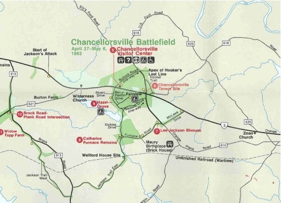
By 2004, FSNMP’s driving tour map advertised the trail at McLaws Field. The 2009 update advertised a dedicated stop on the driving tour there.[14] Along with the trail and corresponding brochure, the tour stop finally allowed FSNMP to open up its story of Chancellorsville to include more of the events from May 1.
CVBT’s arrival on the scene was a significant game-changer—and it’s most valuable contributions to the Chancellorsville battlefield lay just ahead.
————
[1] Toler, Jim. “Chancellorsville battle recalled: Civil War Trust sells piece of battlefield to the park service.” Free Lance-Star. 4 May 1998. pg. A4.
[2] Toler, Jim. “Civil War property purchased: Chancellorsville land will be preserved.” Free Lance-Star. 5 September 1997. pg. A1.
[3] CVBT. “The Next Challenge.” The Skirmish Line. 1 October 1997. pg. 1.
[4] CVBT. “Historic Significance of McLaws’ Wedge.” On the Skirmish Line. 1 October 1997. pg. 3.
[5] CVBT. “The Next Challenge.” One the Skirmish Line. 1 October 1997. pg. 3.
[6] CVBT. “Why We Preserve.” On the Skirmish Line. January 1998. pg. 2.
[7] Ibid, pp. A1 & A4.
[8] Toler, Jim. “Chancellorsville battle recalled: Civil War Trust sells piece of battlefield to the park service.” Free Lance-Star. 4 May 1998. pp. A1& A4.
[9] Douglas, Kim. “Chancellorsville battle recalled: In fund-raising effort, re-enactors trace the steps of soldiers.” Free Lance-Star. 4 May 1998. pp. A1& A4.
[10] Krick, Robert K. “New historical light on the scene of CVBT’s first major preservation triumph.” CVBT files, dates 27 August 2005. In the three-paragraph piece, Krick goes on to include a sentence from letter written by McLaws about his opponent, Colonel Nelson A. Miles.
[11] http://www.cvbt.org/accomplish_mclawswedge.html
[12] Text for tour stop fives mentions Jackson’s attack, and text for stop six briefly mentions the loss of Jackson.
[13] “McLaws Trail” trailhead sign. Chancellorsville battlefield.
[14] Mink, Eric. Email to author. 30 April 2012.