Shaping Chancellorsville: The Final Campaign for Day One
Part thirteen in a series
Although Dogwood Development’s effort to develop Chancellorsville’s Day One battlefield went down in defeat, owner John Mullins still looked for opportunity to develop the property. Preservationists, meanwhile, offered to buy the land from him, but he asked an “outrageous” $40.[1] Acrimony increased as the debate raged publicly in the media, intensified by the continued use of “battle” metaphors in headlines and leads.
Finally, in June, the president of the Central Virginia Battlefields Trust (CVBT), Mike Stevens, used the occasion of his election to write an open letter to Mullins, suggesting they “take the battle out of the Chancellorsville issue.”[2]
As Mullins pushed forward, preservationists continually reached out to officials in local, state, and federal government. In one such instance, they pleaded their case to Les Brownlee, secretary of the army. Because of streams that bisected part of Mullins’ property, the Army Corps of Engineers oversaw permitting approval. “General Robert E. Lee achieved his greatest victory at Chancellorsville,” said the Advisory Council on Historic Preservation in its letter. “Chancellorsville was the last battle where Lee and Thomas J. ‘Stonewall’ Jackson fought together against Union forces; on the second day of the battle, Jackson was mortally wounded.” It went on to say that the development would
directly impact what is called the ‘Lick Run’ element of the First Days’ battle where Confederate picket and encampments were located the night of May 1 to consolidate their gains to the north and west during the fighting on that first day. These pivotal events of May 1 resulted in General Joseph Hooker, the Union Commander, losing his initiative and allowing Robert E. Lee to once again take the offensive over the next two days.[3]
The issue would not be settled, after several more convolutions, until October of 2004. “The rolling farmland where the opening shots of that pivotal [Chancellorsville] campaign were fired will be protected from development!” exclaimed Stevens in a letter to CVBT members. A local developer, Tricord Homes, had purchased the land from Mullins and, in exchange for zoning concessions on the property, offered to set aside 140 acres of core battlefield for preservation. The compromise was hailed as a win-win-win scenario for the developer, the county, and preservationists.
Looking at the battle over the Day One battlefield, which stretched for nearly a decade, it’s worth noting that no consistent historical memory emerged over time as the dominant theme. CWPT framed the ground in terms of the Lee-Jackson stories, and CVBT framed the ground in terms of “first combat of the battle.” Other groups employed both to varying degrees.
The media, unsurprisingly, used the Lee-Jackson angles because they provided such readily familiar hooks for general readership. The media also played up the “Second Battle of Chancellorsville” theme, no doubt because it was likewise catchy. CWPT successfully employed the same approach for the same reason.
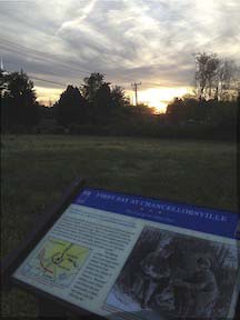
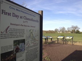
When preservation groups finally installed interpretive signs on the ground, the first and largest sign visitors see on the site combines preservation history with a Jackson theme: “Developer’s Plan Runs into a ‘Stonewall.’” Signs throughout the battlefield talk about the strategic military situation (including a wayside that depicts the Julio painting), the tactical military action, and various civilian stories; no waysides include interpretation related to the Emancipation memory.
Significantly, the last sign at the far end of the four-mile trail is a wayside dedicated to “The End of the First Day,” setting the scene for the next step in the battle’s chronology. The sign features a sketch of the Crackerbox Meeting.
————
[1] Ibid.
[2] The headline for the letter, which appeared 10 June 2003, was actually drafted by an editor at the Free Lance-Star, where the letter appeared; the phrase does appear in Stevens’ actual letter.
[3] Castro, Bernadette. Letter to Les Brownlee. 18 July 2003.
I visited the battlefield a week ago. It is very dangerous for school teachers and historians to visit the locations because of the heavy traffic and the speed in which the Virginians are allowed to drive. Even more congestion would further place people in danger. There almost needs to be bridges to allow people to walk the battlefield. This would “ruin” what is left of the view, but Hwy 3
is very dangerous for people to slow down or stop to see the historical sites. The battlefield of the Wilderness is also very dangerous without “pull outs” for those in cars.