Mapping the Petersburg Campaign: Sutherland Station
I have come to believe that the primary reason why Petersburg is an often overlooked campaign in the scope of the Civil War is the challenge of understanding its nine and a half month progression. There is no shortage of thrilling stories, detailed primary accounts, or battlefields to visit. It is just a matter of not being able to wrap one’s head around it. (I’ll here similarly admit I tend to avoid reading about cavalry actions for the same reason.)
Rather than continuing to bemoan this fact, however, I’ve determined to be the change you want to see. I hope those who attended the Third Annual ECW Symposium left with a better appreciation for the final day of the campaign, even if it was based off the maps I created more so than my own interpretation. Nearly every Civil War scholar and buff could draw a pretty accurate map of Gettysburg, Antietam, Shiloh, Chancellorsville, or Chattanooga. Let’s do that with Petersburg.
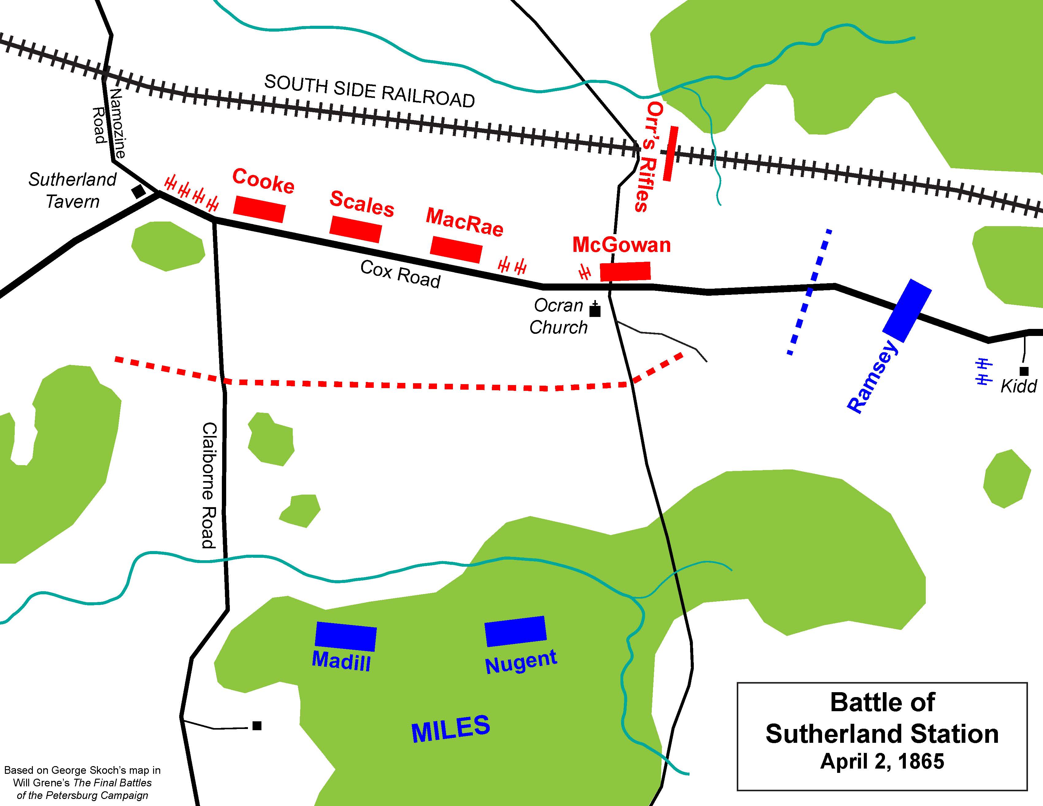
Last week I prepared handouts for a Pamplin Historical Park sponsored car caravan tour of the Sutherland Station battlefield. On the afternoon of April 2, 1865, a Confederate quasi-division led by John Rogers Cooke repulsed two charges from Nelson Miles’s II Corps division before being flanked and forced to withdraw. This yielded the South Side Railroad–Petersburg’s final supply line–to the Federals.
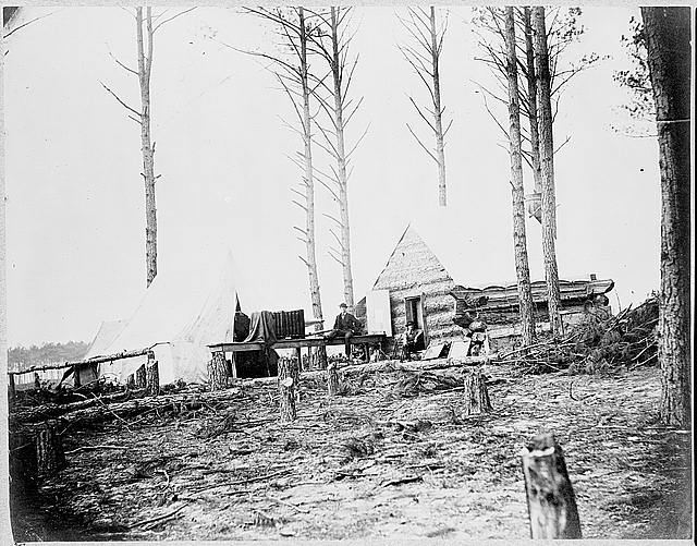
The combat is a footnote on the most tumultuous, yet exciting day of the war. There are some great descriptions from both sides of the battle but no full study or even a standalone article about it. I’ll shamefully admit I relegated Sutherland Station to just a photo caption in my own book. While compiling my tour handouts I found only a few maps and just one only highly inaccurate drawn sketch of the engagement. In my quest for an image of the South Side Railroad I went down a rabbit hole and ended up stumbling upon a neat (and relevant) picture of Civil War mapmakers.
The image referred to can be found on the Library of Congress’s webpage – https://www.loc.gov/item/cwp2003001121/PP/. I found a better image for zooming, though, on the Metropolitan Museum of Art’s site – http://www.metmuseum.org/art/collection/search/286664.
It’s titled Quarters of photographers attached to Engineer Corps in front of Petersburg with a provided date of March 1865. As the miles of massive fortifications and layers upon layers of obstructions suggest, the engineers for both armies were kept busy enough from June 1864-April 1865. Their production was not limited, however, to just designing perfect killing fields.
Among their other responsibilities was the necessary task of providing their generals with a solid understanding of the terrain upon which they were to fight. Major Nathaniel Michler had a crack team working for him in developing maps of most of the eastern theater battles. Michler himself earned brevet promotions all the way to brigadier general. (A brief biography of the mapmaker can be found on a colleague’s blog)
I probably consult his Petersburg contribution every day. The Library of Congress has the full 1867 version of Michler’s masterpiece available for download on its webpage, but researches would do well to track down the detailed quadrant maps.
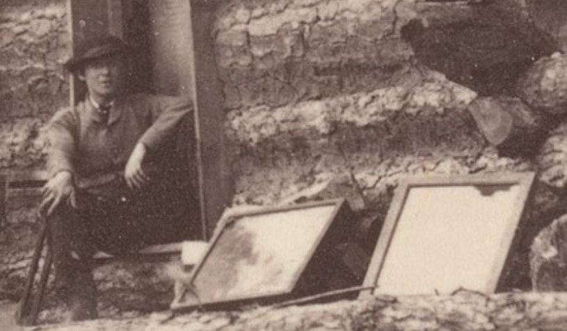
To distribute the early renditions of this map to their subordinates without having to waste time tracing by hand, the Federal high command called upon the photographers who traveled with the army. Their process and equipment can be seen when zooming in on the above photo. The descriptions are taken from the Met’s collection record:
“Civil War photographers duplicated maps and important military documents using a copy camera set up like the one shown in this view.”

“Leaning against the log cabin are a pair of contact printing frames tilted toward the sun.”
Sure makes my own process of photocopying, collating, and stapling seem less a burden.
Time for a maps book like the others from Savas Beatie. I woul love to fly over the area with someone who knows the area well as it is very difficult to grasp all of this from the ground. It would be neat to see an overlay on google maps or a large model or both.
It took me 9 months to read “Richmond Redeemed” and it only covered one phase of the siege.
Earl McElfresh’s Maps & Mapmakers is an interesting read on the topic. In doing my master’s work at the Command & General Staff College 10 years earlier, I found that the Army of the Cumberland’s map gathering & distribution system was far superior to the other armies. The success was due to the expertise and organizational ability of topographical engineers William Merrill & Michler with the support & understanding of their army commanders Rosecrans & Thomas.