Hiking to Harpers Ferry for the John Brown 160th

 Bill Bryson did for the Appalachian Trail what Tony Horowitz did for the Civil War. In his 1998 book A Walk in the Woods, Bryson recounted his adventures hiking portions of the AT with his woefully under-prepared friend Stephen Katz, sharing stories about the people he met and the things he learned along the way, employing the kind of immersive journalistic approach Horwitz used in Confederates in the Attic.
This week, I’m combining the two—the Civil War and the AT—in conjunction with the 160th anniversary of John Brown’s raid on the Federal arsenal at Harper’s Ferry.
The AT is some 2,180+ miles long, but I’m concentrating on a single 11-mile stretch from Gathland State Park on South Mountain down into Harpers Ferry. I’ve wanted to hike this stretch for a while, simply to see if I can, and the Brown anniversary seems to finally present the impetus I’ve needed. My goal is to do the hike and see if I learn anything or come to any insights along the way.
I even have my own Katz: Terry Rensel, the executive director of the Central Virginia Battlefields Trust and a member of the ECW editorial board. He gleefully announces his willingness to serve as comic foil if the trip needs one. Fortunately, Terry seems better prepared for the trek than the junk-food eating Katz, but he’s carrying a few extra pounds and admits he’s not in tip-toppest shape. “But I will still walk you into the ground,” he vows. “I might fall over on the very next step, but I will not be outdone!”
As we plan the trip, we opt to leave my car near the rail station in Harper’s Ferry and hire a shuttle to drop us off at Gathland. We arrive shortly after eight a.m. Although the park doesn’t open until nine, a lone Park Service ranger sits in the parking lot, getting out of the back seat of her own car to politely collect admission fees from early arrivals like us. Terry’s Park Service Annual Pass gets us a spot for free.
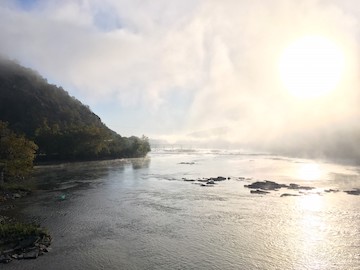
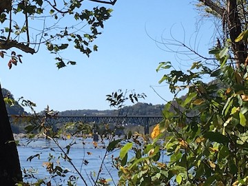
We have some time before pickup, so we walk down to the convergence of the Shenandoah and Potomac Rivers, a scene Thomas Jefferson once described as “perhaps one of the most stupendous scenes in Nature.” Most of the morning fog has since burned away, but some mist lingers in the shadow of Loudon Heights on the south bank. The sun is just lifting itself over the ridge of the heights to look down into the valley. The rivers here are shallow and the bottom rocky. The sun makes the most of the turbulent water, which shimmers brilliantly.
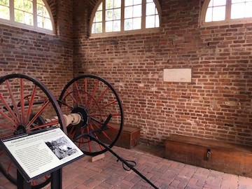
On our way back, we detour into John Brown’s fort. Once the fire house for the arsenal, the building served as the last stand for Brown, 18 of his men, and assorted hostages after the raid dissolved into disarray. Lt. Col. Robert E. Lee, still in the U.S. army at the time, led a company of Marines to quash the raid. Jeb Stuart, also a U.S. army officer, served as Lee’s right hand.
I’m always struck by how small the building is on the inside. With the wooden doors thrown open as they usually are, plenty of light and fresh air spill in, but I wonder about the stink of fear and despair that must have clogged this room as Brown’s trapped men realized the Marines had surrounded them and there was no hope of escape. The siege lasted thirty-six hours—plenty of time for the air to grow thick with defeat. (Visit the ECW YouTube page to see the short video I shot inside.)
The shuttle arrives a few minutes late, but the driver, a lanky dude in his late twenties, greets us pleasantly. “I don’t own the company,” he says. “I’m just the driver.” He makes his living, or at least part of it, dropping people off and picking them up as they hike parts of the trail. He’s come down from Shepherdstown to get us. “This is about the shortest pickup we like to do,” he says. “It’s a popular one. A lot of people like to get dropped off and hike down into Harpers Ferry.”
We must pass some sort of silent inspection because he tells us conspiratorially about past clients who’ve severely misunderstood the trail: people who don’t bring enough water, people who wear casual shoes instead of something designed for rugged hiking, people who bring their tiny “toy” dogs that aren’t cut out for the rigors of the experience. One woman once brought a piñata. “It was filled with candy, and she had it set up so that if the people hiking with her wanted a piece of candy, they’d have to reach into the piñata’s ass to get it,” he explained. “And then the person would have to carry the piñata for a while. She had it all figured out that she could have candy and not have to carry the thing. But her friends were all like, ‘Fuck that.’ I still wonder how that turned out. I took a picture.”
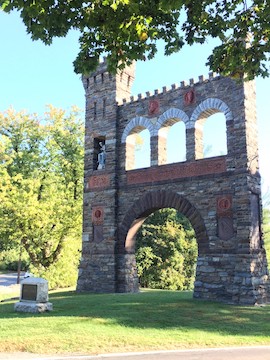
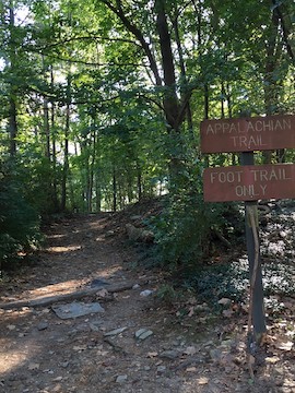
The road winds up to the top of Crampton’s Gap where the Civil War Correspondents Memorial stands vigil. It’s one of my favorite Civil War spots. George Alfred Townsend—known in the 1860s by his penname “GATH”—erected the monument and the small cluster of buildings that would eventually become Gathland State Park. Our shuttle driver deposits us near Townsend’s mausoleum, which Townsend designed but then never occupied. The southbound trailhead leaves from the edge of the parking lot.
We click our walking sticks together like a pair of early morning pirates crossing swords and then take to the trail.
Temperatures are supposed to get into the seventies by day’s end, but now, just after 9:30, it’s a cool sixty. Most of the leaves remain on the trees, and most remain green rather than amber, orange or crimson, so we walk in the shade. The sun-dappled trail reaches out ahead of us, wide enough for us to walk side by side. “In the full sun, in the summer, I could see this being brutal,” I say. “But jeez, this couldn’t be more pleasant.”
It wasn’t so pleasant on September 14, 1862. Confederates under Brig. Gen. Howell Cobb fought at Crampton’s Gap to stave off an advance by Union Maj. Gen. William B. Franklin’s far more numerous forces. Although a Union victory, the Confederate defense—and Franklin’s own case of the slows—delayed Union forces enough that they could not come to the relief of Harper’s Ferry, besieged by Stonewall Jackson.
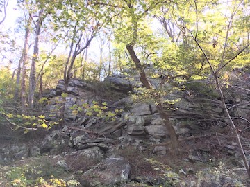
The trail run parallel to the Confederate position. The ground is rocky and the mountainsides steep. “This is unforgiving ground,” I say. “I can’t imagine trying to assault uphill against this.”
While topography favored Howell, numbers favored Franklin, whose men swept to the crest and, after a sharp fifteen-minute fight, carried the position.
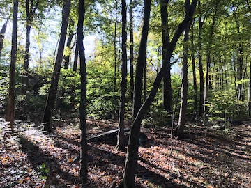
Like so many other Civil War battlefields, the beauty of the battlefield today belies the violence that once took place here. Spiderwebs along the trail, still clinging to morning dew, catch shafts of sunlight. We see a few squirrels, but no deer or bear or even anything as big as a racoon or fox.
Conversation passes the time. We talk some Civil War, but we talk about the Founding Fathers, too—another of our shared interests. We revisit our old college days together, lament the girls who’ve broken our hearts over the years, and armchair-umpire the current baseball playoffs. (Go, Yankees!)
A jogger with her dog passes us from behind. The path is mostly packed earth, but plenty of rocks make for an uneven surface overall. How the woman manages not to trip mildly amazes me. An hour or so later, a second jogger, this one a high school long-distance runner, fleets by. We also pass a pair of hikers, plugging along with those ski-pole things for hikers, coming in the opposite direction. By the time we stop for lunch at a shelter four miles down the trail, they are the only four people we’ve seen.
We break out trail mix and jerky and swig from our water bottles with zest. My wife had left out the fixin’s for PB&Js for me, which I made before departing, and I text her a thanks for her brilliant idea as I savor them. “I can’t believe I’m up here on a mountain and I still have four Gs,” Terry marvels.
We meet two guys who are on day two of an overnight hike. They wrap up and, with ski poles off their own, head south down the trail about ten minutes before we wrap up, too. As we do, we meet a couple and their pit bull who are also wrapping up their lunches. They put in at the Pennsylvania/Maryland line on Thursday and have come this far over the long holiday weekend. They intend to hike all the way through to the AT’s terminus in Georgia.

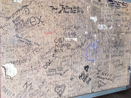
We sign the log book in the shelter—“John Brown 160th,” I write by my name—and then set off southward. We’re soon again revisiting the glory days of our youth, gawking at the scenery, and talking shop. Aside from his work with Civil War preservation, Terry has an interest in Winston Churchill and Theodore Roosevelt. “With your TR interest, you should go check out the Woodrow Wilson presidential library in Stanton, I suggest.
That in turn leads us to Wilson’s tomb in D.C.’s National Cathedral, which morphs into a discussion about the cathedral as an eclectic collection of memoria. “It’s definitely worth checking out,” I tell him.
“I don’t know,” he replies, “the thought of you and I going into a house of God at the same time. We might burst into flames.”
Suddenly he sprawls. His toe caught a rock sticking out of the path—face first, headlong, downhill. His knees drive into the dirt, then his elbow hits another rock, then his backpack drives him chest-flat into the ground. His walking stick clatters away, his sunglasses spin off his head down the path, and his aluminum water bottle clangs off more rocks. He skids to a stop, face down.
A small pyramid of rock jets out of the path near his left temple, and at first I think he’s hit his head on it. But he huffs and groans and, slowly, flips himself onto his back like a turtle resting on its upturned shell. He unsnaps the buckles of the straps across his chest and shrugs off his backpack’s shoulder harnesses, then sits up. I offer to help him up but he shakes his daze head. “I need a second to get my wits about me,” he says.
While I retrieve his spilled belongings, he does a quick check: nothing bleeding, nothing broken. He fishes a pair of Aleve tablets from the top of his backpack. “Best pop a couple of these to get in front of it,” he says, his voice still a little shaky. But eventually he’s back on his feet and we get him strapped back into his pack. “That’s what I get for making a joke about God,” he grumbles. He looks heavenward and shakes his fist and blasphemes something I pretend not to hear.
Eventually, the path begins a steady decline. Even as it does so, the stretches of hard packed dirt gives way to rock fields, which have been only occasional up to this point. Now the going gets so tricky we can no longer talk because we have to concentrate on where we step. The uneven walking begins to tell on our ankles, which begin to protest all the stretching and straining. I give my left ankle a slight twist—nothing that stops me or slows me down but which makes the ankle feel looser than it should. I realize that a strain, a sprain, a break up here could be potential calamity.
We finally come to a fork that leads, one way, to Weaverton Cliffs two-tenths of a mile farther on and, the other way, toward the final descent to the foot of the mountain. We take the detour and admire the view from the cliffs. The Potomac River pushes its way between two mountains with confidence before it rounds another bend and is lost to view behind trees growing up in front of us from the cliffside.

I’m a little distracted by other people who’ve suddenly appeared. A dozen or so, anyway—more people than we’ve seen all day. Many seem to show little regard for the sheer drop. One father puts his seven-year-old daughter on his shoulders and springs across the rocks to the edge as she, all the while, pleads, “Daddy, no! I’m scared! No!” I see his feet slide a little and wonder if he’s going to spill them both over the edge, but he catches himself. I have to stop watching.
The two-tenths of a mile hike back to the fork is just arduous enough that I begin to doubt if the stunning view was worth the effort. Terry sounds like he’d ready to keel over. But at the fork, a gaggle of twenty-something women and men gambol up from the mountain’s base. Can’t look weak in front off them! I silently resolve. I get past them, then wait for Terry, whose machismo has likewise given him a burst of new energy.
“The path down has sixteen switchbacks,” Terry told me earlier in the day. As we start down, I feel like a burro making its way down the Grand Canyon. The cliffs are apparently a popular local attraction, because we pass many people climbing their way up as we make our way down, and only a few are dressed for serious hikes. Families with small children. Dog walkers. A tired woman in her sixties who has grabbed a dead tree branch from the trailside to use as a walking stick. A little girl wearing jelly shoes. “Her dad should know better,” I grumble.
Terry descends slower than I and wears an expression of caution in place of his earlier bravado. We’re both feeling the descent—he in his quads and me in my hips—but I’m also feeling invigorated. From here into Harper’s Ferry, the path will be flat along the C&O canal path. We’ve conquered the mountain.
“I’m glad we chose to come down rather than tackle in the other direction,” Terry says. “I would hate to go up that thing.”
“I wouldn’t mind it,” I counter. “Not right now, of course.”
The canal path proves challenging in its own way. The packed cinders are hard underfoot, and there’s less shade overall, so the walk gets warm, especially now that the temp has finally peaked in the upper 70s. The views aren’t spectacular, even along the river, until the very end. We get bored.
Bikers ding their bells as they come up behind us a zip by, over and over and over. Many of them sport camping gear. “I knew a guy that did this whole thing all the way to Pittsburgh,” Terry tells me. “Camped along the way.”
There’s definitely less talk between us. We’re not tired, per se, just worn.
Finally, we glimpse Harpers Ferry ahead of us. As we get closer, a church steeple looms up from the trees—St. Peter’s Catholic Church high on the hillside overlooking historic downtown.
Terry has saved something for this moment. From the top of his backpack, he has me pull out a small flask. He unscrews the metal cap and raises it in toast. “Maker’s Mark,” he says. “I wanted something smooth.” He takes a hit and I follow. I chase it with a couple swigs of water.
Terry spills a little on the ground. “One for my homies,” he says, then takes another swig. He offers me a second, but I decline. A few minutes later, I reconsider and take a second hit. I’m not a bourbon fan the way Terry is, but in this moment, the second swig feels right.
We climb onto the railroad bridge that takes us across the Potomac and back to the point of land where we started the day. Dozens of people mill about. John Brown’s fort likewise has traffic in and out.
In the parking lot, we reach my car and I slap the back trunk. “Done,” I declare. “We did it.”
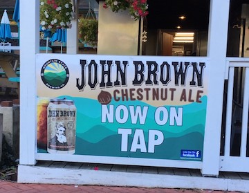
We have time to do some sightseeing, but it turns out the first order of business is a cold beer at the Almost Heaven Pub and Grill across the street. A waitress directs us to the upstairs bar where we grab a couple corner stools and, lo and behold, we find John Brown waiting for us there—in Chestnut Ale form.
Sitting down invites the aches and pains to settle in. I popped a couple preventative ibuprofen back at the car, but I know they’ll only take the edge off at best, so we finish our beers and get ourselves moving again.
We try the John Brown museum around the corner—something I’d been looking forward to all day as a capstone to my John Brown-inspired hike. Here’s where I hope inspiration will strike somehow and help me figure out what insight I can take away from today’s adventure.
Terry snaps pictures with his camera while I study the mural in the front entranceway: John Brown, the crazed prophet of doom, a look of wildness in his eyes, his, arms outstretched Christlike, with Bible in one hand and gun in the other, and a tornado ripping by in the background, soldiers square off, battle flags flutter, and Brown’s hipster beard a hundred and forty years before they came into fashion standing out almost sideways in its own independent defiance of physics.
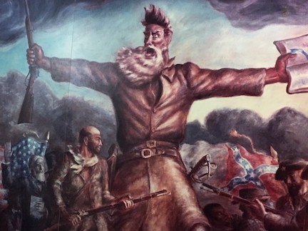
“This dude was batshit,” I tell Terry, who’s still snapping away.
We go into the first exhibit hall, but the movie has just ended and won’t restart for another four minutes, so we go into the second exhibit hall for the second movie. We soon realize our mistake as the aches and pains flare up, but we’re surrounded by tourists and can’t escape, so we have to ride it out. As soon as the program ends, we somehow get to our feet, although the process feels like a slow, creaky unfolding of sorts. We decide to skip the final movie, about Brown’s trial, afraid our whole bodies will seize up if we stop moving again.

The light outside seems harsh and overly bright, perhaps because we’d just been in the museum but perhaps because we’d been under a green canopy most of the day. We duck into the bookstore, then scurry along the sidewalk that takes us back to the car. If we’re going to explore John Brown’s legacy at Harpers Ferry, it’s going to have to be on a day when our hike-exhausted bodies aren’t in danger of betraying us.
But there will be another day. There’s a hike up to Maryland Heights awaiting to see Lafayette McLaws’ position during the 1862 siege. There’s more AT. There’s more South Mountain. There’s Antietam.
Later, when I tell people about the day’s hike, several ask, “Are you crazy?”
And suddenly, I understand just a little bit how John Brown must’ve felt after his own trip to Harpers Ferry. Crazy? Maybe. Depends on who you ask, I suppose.
Congrats on completing the hike. The A.T. can be quite tough for those not prepared. And, those “ski poles” you described are actually called trekking poles. Very helpful during a hike.
Thanks, Craig. My unfamiliarity with the proper terminology only underscores my inexperience at serious hiking. My experience with the Great Outdoors has mostly been as an outdoorsman than as a recreational user, if that makes sense.
Chris: Congrats on doing the hike. Folks actually do use ski poles for this, as well, and they can be helpful – although trekking poles are specifically designed for backpacking so they’re probably better. I can verify that they are lifesavers for doing things like humping 50 lb loads on climbing trips into the Wind River Mountains in Wyoming. You also encountered one annoying feature of the AT – roots and rocks on the trail. I don’t care how much of this you do – you will still stumble over those from time to time.
Entertaining vignette; you should have filmed it for Youtube!
Big brownie points to you! That sounds like a ton of fun and a heap of work. My husband and I visited all of Harper’s Ferry last August and loved it. We hiked from the visitor center and bus station to the Murphy-Chambers Farm Trail, which is nothing compared to what y’all did. There we saw where John Brown’s Fort was relocated between 1895-1909. But your experience reminds me of when I hiked the entire Vicksburg battlefield. That was about 17 miles and took two days. That was a doozy. I hope you do more blog posts like this!