Alfred Waud’s Sketchy Spotsylvania (part one)
In my capacity as historian-in-residence at Stevenson Ridge on the Spotsylvania Court House battlefield, I recently did some work to pin down the approximate location where IX Corps division commander Brig. Gen. Thomas Greely Stevenson was killed on the morning of May 10, 1863.
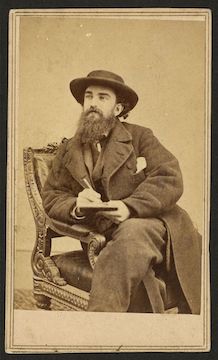
Part of that work has hinged on the Official Records and first- and second-person accounts of the event. Part of it has hinged on topographical work done by engineer Nathaniel Michler, then working as chief engineer for the Union V Corps. And part of it has relied on a sketch by artist Alfred Waud titled “The advance on Spotsylvania. 9th May.”
And, quite unexpectedly, I seem to have discovered that Waud’s sketch is mis-dated.
Since this bucks 157 years of conventional wisdom—not to mention the author’s own label on the sketch—let me show you the trail of bread crumbs that have led me to this conclusion. I’ll walk you through, crumb-by-crumb, over the course of a couple posts so things are as clear as possible. (Fair warning: some folks find the crumb-by-crumb approach tedious, so I won’t be offended if you skip it!)
I want to start today by outlining the work Waud did during the first week of the battle of Spotsylvania Court House. We’ll do that by looking at what he sketched and where those sketches are situated on the battlefield. He did other sketches later in the battle, but for the purposes of this discussion, we’re going to confine ourselves through May 13.
We’ll start when Waud leaves the Wilderness. Before heading south on the Brock Road, Waud sketched Gen. Alexander Webb on the Brock Road:
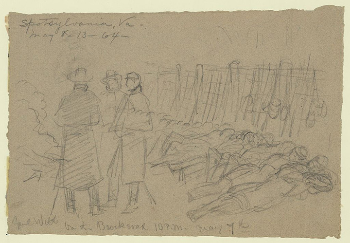
“This sketch made while Genl Webb was on the extreme left momentarily expecting the order to move on Spotsylvania Ct. ho.,” a note on the back says. “The men lay along the log works muskets against them- canteens and haver-sacks hanging -etc- very dark except for the light of a fire.” It’s marked as 10:00 p.m. on May 7, which gives us Waud’s approximate time and place.
However, according to Webb’s official report, Webb’s brigade was “on the right of the First Division” for most of May 6 and 7 “until about 8 p.m. [on the 7th], when we moved to the right and took position on the right of the plank road, relieving the Fourth Division.”[1] This does NOT situate Webb on “the extreme left” of the Union line. So, either Waud mis-identified the brigade or mis-identified its location along the Union works.
Also worth noting, Waud writes at the top of the page: “Spotsylvania, Va. May 8–13—64—.” This seems to note the phase of the campaign, not a specific time and place (in Spotsylvania, County, for instance, even though they’re in the Wilderness, not Spotsylvania Court House). I mention this as a bread crumb because in several places Waud makes similar inexact or incorrect notations.
Farther down the Brock Road, Waud sketched “The army marching part Todd’s Tavern.”
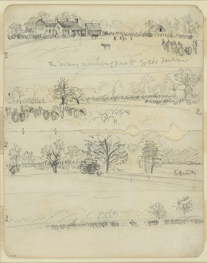
This drawing includes four rough sketches of the area that depict the buildings in great detail. Waud either had to wait until first light to see them well enough or he had to double-back to see them later in the day. This suggests he made the sketch sometime on the morning on May 8 as the army filed southward, although he might have doubled back later in the day to capture the scene. The army had a presence in the area well into the night on May 8 as Winfield Scott Hancock’s II Corps first encamped there late in the day, then moved into its position at Spotsylvania on the Union right near the Po River.
The head of the advancing Federal column reached the outskirts of Spotsylvania on the morning of May. In that vicinity, on the sector of the battlefield now known as Laurel Hill/Spindle Field, Waud sketched “Warren rallying the Marylanders”:
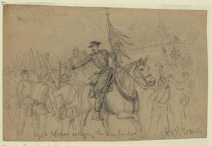
Following a morning repulse, V Corps commander Maj. Gen. Gouverneur K. Warren tried to rally the four Maryland regiments of Col. Andrew Denison’s command. Waud noted “White horse/ragged flag” on the sketch.
This drawing later appeared in woodcut form in the June 11, 1864, issue of Harper’s Weekly:

Also from that same area of the battlefield, Waud did a sketch of “Spot where Genl. Sedgwick was killed”:

Sedgwick was shot by sniper fire on the morning of May 9, 1864. It’s worth noting that Waud does not sketch Sedgwick’s death itself but rather the spot where it happened, suggesting he was not on the front to see it happen.
Inscribed in the upper left of Waud’s sketch is “Co. B. 14. Jersey.” Inscribed in the upper right: “3rd N.Y. Independent A.M.”
A woodcut of this sketch appeared in Harper’s Weekly, in the June 4, 1864, issue:
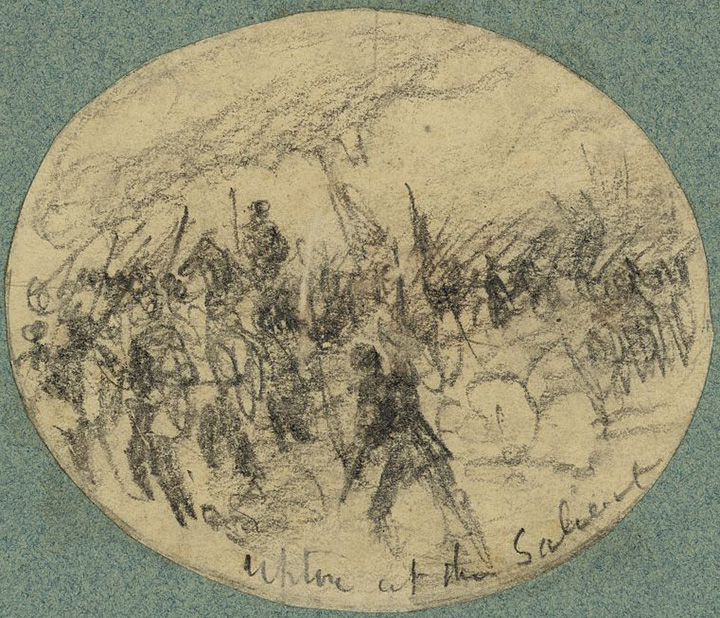
Waud captured action from the following day, May 10, in a sketch titled “Upton at the Salient”:
In the early part of that action, Upton took several hundred Confederate prisoners. Waud captured the capture in a sketch titled “Rebel prisoners captured in the charge of Genl. Wrights Corps–running in”:
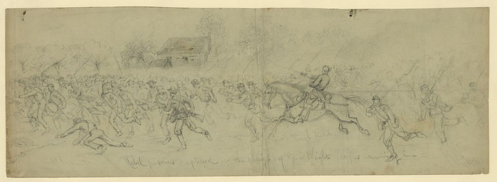
“Rebel prisoners” was sketched behind the lines near the Shelton house. We know Waud witnessed this personally because he recounted it to Meade’s aid, Theodore Lyman. “The nomadic artist Waud said it was a fine sight to see the prisoners brought in on the double-quick in a great herd,” Lyman wrote.[2]
A woodcut version of that sketch appeared in the June 4 issue of Harper’s Weekly:

As a side note, Waud was apparently unimpressed with the way the paper handled his work. “[V]ery good sketches he sends them, and very poor woodcuts they make thereof,” Lyman noted. “His indignation has, long since given place to sarcasm; for W[aud] is a merry & philosophic Bohemian!”[3]
We don’t have any sketches from Waud that depict any action that occurred on May 11 (more on that later in the series), but we do have a sketch showing Mott’s division of Hancock’s II Corps getting into position for its assault on the Mule Shoe Salient in the early morning hours of May 12:

Waud wrote “May 12th fight 1864. The Brown House. Spotsylvania Ct. Ho.” The sketch was done on two sheets. The tan overlay specifies “Gen’l Mott’s division.”
From later that morning, Waud sketched “12th May Hancock and Wright fighting for the enemies rifle pits sketched from Lundmans [Landrum] house”:
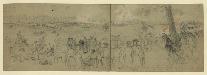
Waud’s tiny chickenscratch is hard to read here, so while the Library of Congress has transcribed the house name as “Lundman,” I presume it’s actually “Landrum,” a farmhouse where Hancock made his headquarters during the May 12 attack. Waud inscribed directions to the woodcutter in the upper left of the image: “Try & get a little gradation of tint and color out of the engraver.” Above the image, Waud wrote: “Rainy day time 6 o clock.” (My favorite detail in the picture is Brig. Gen. Francis Barlow, seated, wearing his famous checkered shirt.)
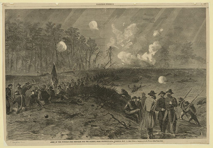
Then, of course, comes perhaps Waud’s most famous sketch from Spotsy, which shows “The toughest fight yet. The fight for the Salient”:
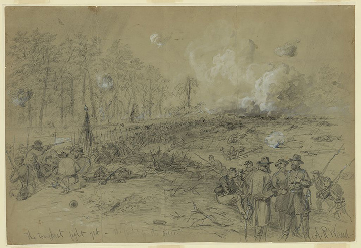
That appeared as the centerfold in the June 11 Harper’s Weekly:
Spotsylvania-based historian John Cummings has done excellent work situating the location where this sketch was drawn from. It’s worth checking out John’s work on this image. “Although Waud, and the other newspaper special artists of the day are characterized as having crawled toward an engagement and sketched a battle as it unfolded,” John says, “I have no illusion that he would have done so at this hot a location.” I agree with John’s conclusion. It’s more probable that Waud sketched this image on May 13 well after the main fighting at the Mule Shoe had finally quieted.
From these sketches so far, we know Waud arrived in Spotsylvania with the main column of the Army of the Potomac on May 8 and sketched action that took place with the V and VI Corps from May 8-12.
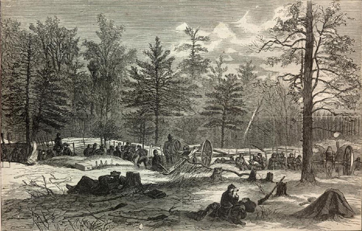
There’s also a woodcut from the June 18, 1864, Harper’s Weekly depicting one other scene from that sector of the battlefield. The sketch depicts “a picturesque shelter erected by our soldiers, near the spot where General SEDGWICK was killed, as a protection against shot and shell from the rebel lines. The picture is full of interest as exhibiting what novel methods our soldiers resort to for purposes of defense from the casualties of battle”:

I’ve not seen a copy of Waud’s original sketch. Another original sketch I’ve not seen, but one that was also adapted into a woodcut, was “Batteries on General Warren’s Left, Near Spotsylvania, Virginia.” The woodcut appeared in the June 11, 1864, issue of Harper’s Weekly:

There’s nothing that indicates the date of the action shown in the image. It could be any time between May 8 when Warren first arrived on the field through May 12 when he launched another round of attacks against Laurel Hill in an attempt to alleviate pressure on the Mule Shoe. Another option is that it shows Warren’s position on the far left of the Union line after Grant shifted the V corps from the Laurel Hill sector all the way over to the Fredericksburg Road on May 13-14. Warren’s men stayed on that part of the line for the second week of the battle. This would also better explain the houses in the image (although Sarah Spindle’s home near the Brock Road did still stand on the morning of May 8).
Accompanying the “Batteries” sketch in the June 11 Harper’s Weekly were two additional sketches, both from the far side of the Fredericksburg Road side of the battlefield. That all three appeared on the same page lends weight to the idea that the sketch of Warren’s batteries come from his new position.
The first was a sketch of Spotsylvania Court House itself:

“SPOTSYLVANIA COURT HOUSE, as it is presented in Mr. WAUD’S sketch, is seen to be a mere hamlet, lying amidst surrounding woods,” Harper’s reported. “It is the capital of Spotsylvania County, and contains a court house, a jail, an Episcopal church, two or three stores, and probably 200 inhabitants. Our sketch was taken from a point within the Federal lines. The rebel rifle-pits appear in the distance.”
The woodcut was based on a series of sketches Waud made, one atop the other, that needed to be strung together to create the full panorama:

The second Harper’s Weekly image shows the Union army crossing the Ny River:
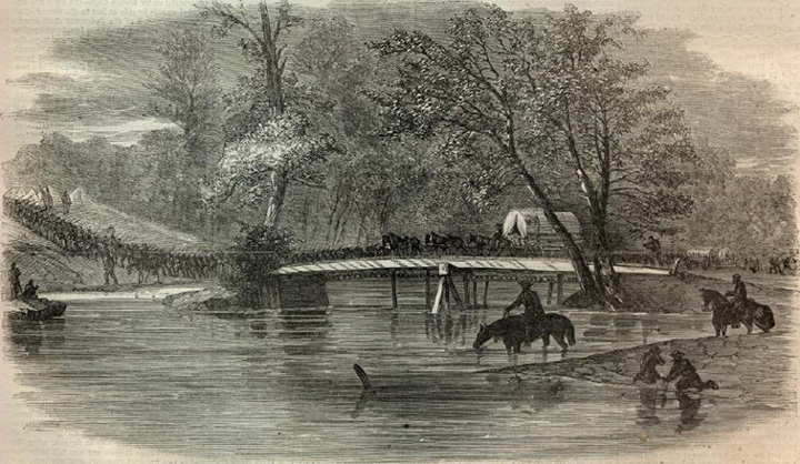
The Fredericksburg Road crosses the Ny River—some reports refer to the crossing as “the little bridge”—before making a final mile-and-a-half push into the village. (In this image, the road brings the army up past what is today Stevenson’s Ridge on the right side.) I’ve not been able to find a copy of the sketch upon which this woodcut is based.
Waud made a final sketch from this side of the battlefield, “The advance on Spotsylvania”:
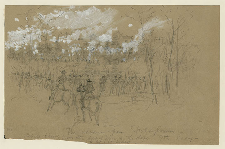
The village of Spotsylvania Court House is visible in the background, with several clearly distinguishable buildings in sight. An inscription on the image says, “Rebels firing from the dwarf pine on the slope to the ct. house.” A line of pine trees still marks the position today, right near the Confederate Cemetery. John Cummings has, as with the Bloody Angle image, done an excellent job of locating where on the battlefield Waud made this sketch.
But now I have come to the nub of the problem: In the lower-left corner of Waud’s sketch, he wrote “9th May.”
I think he mis-dated the image.
My next post will continue to lay out the breadcrumbs so you can see why I think so.
————
[1] Webb, O.R. XXXVI, pt. 1, 438, 439.
[2] Theodore Lyman, Meade’s Army: The Private Notebooks of Lt. Col. Theodore Lyman, David Lowe, ed. (Kent, OH: Kent State University Press, 2007), 150.
[3] Lyman, 166-7.
I don’t think General Burnside was killed at spotsylvania or even during the war.
You’re correct. He lived until 1881, and his postwar career included stints as Rhode Island’s governor and U.S. Senator and as president of the N.R.A.
Kate is pointing out a typo you made where you say “Burnside”, rather than “Sedgwick”.
Found it–thanks
Interesting, detailed article. Thank you.