Alfred Waud’s Sketchy Spotsylvania (part two)
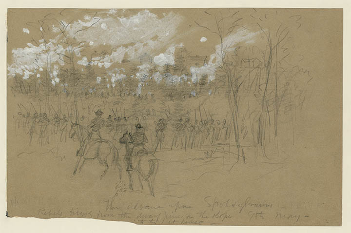
When Alfred Waud finally arrived on the Spotsylvania battlefield’s eastern front, he produced a sketch showing the Federal IX Corps on the outskirts of the village. Spotsylvania-based historian John Cummings has convincingly placed the location of the sketch. You can read John’s work on that here.
Waud dated the sketch “May 9,” but the Union army never made it this close to the village until May 10. I don’t think the problem rests in John’s work locating the spot but rather with the date Waud put on the sketch.
Let’s walk through the action of May 9-11 so we can better understand where the Union army actually was.
This is a map done by engineer Nathaniel Michler after the war, showing all the earthworks on the eastern front of the battlefield:
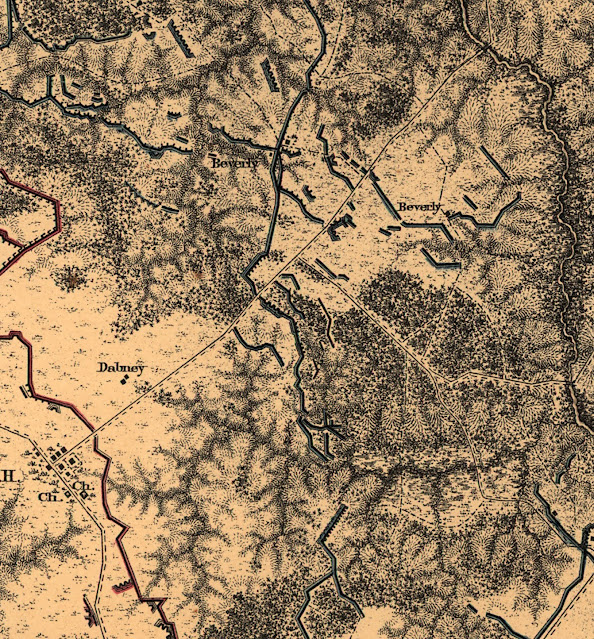
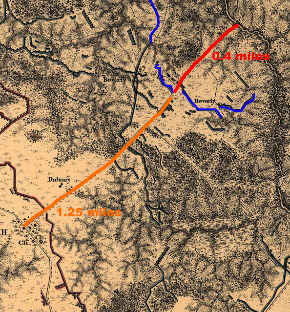
The spot where John has situated the “Advance on Spotsylvania” sketch is here:

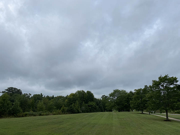
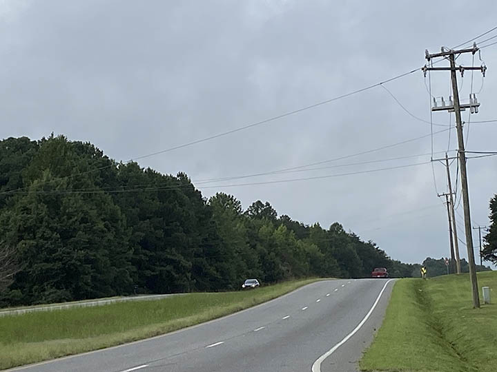
Here’s what a modern view from that spot looks like:
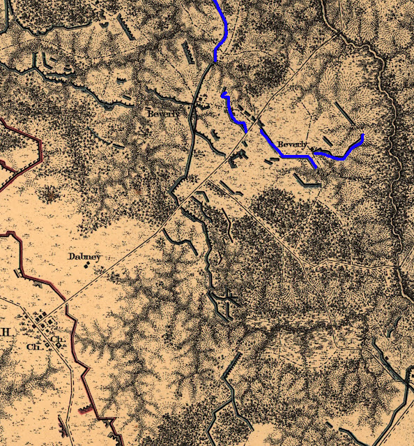
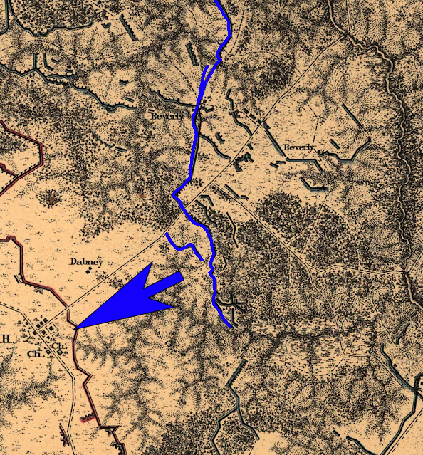
In order for Waud to make his sketch of the Court House on May 9, this stretch of earthworks would have had to be in place:

However, as documentary evidence demonstrates, on May 9, the Federals only advanced this far:
On the morning of May 9, Burnside’s corps got underway by 4:00 a.m., marching from the old Chancellorsville battlefield and eventually approaching the village of Spotsylvania Court House from the northeast along the Fredericksburg Road. Orlando Willcox’s division led the way, with Col. Benjamin Christ’s brigade out front. As Burnside recounted in his official report, his men initially ran into Confederate skirmishers about a mile from where the road crossed the Ny River. Federals drove the Confederates to the far side of the river and seized the bridge. Christ’s brigade then crossed and ascended the slope of the opposite bank, “with two batteries of artillery, which were posted on the crest, about a quarter of a mile from the river,” Burnside wrote. “Several attempts were made by [the Confederates] to drive our people back, which were repulsed.”[1]
Willcox’s official report gives us a different way of measuring the distance his men advanced: “took position within 1 1/4 miles of Spotsylvania Court House, where we repulsed repeated assaults of the enemy, and finally entrenched ourselves.”[2]
Willcox elaborated further in a follow-up report: “Planted my two batteries, Roemer’s and Twitchell’s, on the north side [of the Fredericksburg Road] and took position on the crest of a slope on the opposite side, some 300 yards from the river, with the left resting at one of the Beverly houses [Whig Hill].”[3] Colonel Byron took possession of the house—which he described as “a large house in my front”—for the use of his sharpshooters and posted the rest of his regiment behind a fenceline.[4]
By the end of the fighting, said Cutcheon, “We occupied the crest, and during the afternoon, fortified it as best we could,” Cutcheon said. “Thus this division gained a foothold nearer Spotsylvania Court-House than any other part of the line.”[5]
So, according to accounts, on May 9 this spot “nearer Spotsylvania Court-House than any other part of the line”—of the entire Federal army, in fact—was about a quarter of a mile from the river and a mile and a quarter or so from the village. That puts it right here:
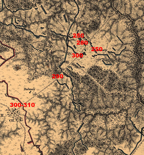
It’s worth noting that Federal estimates of the distance between the river and the crest of the hill (between 300 yards and a quarter of a mile) all fall a little short. But the accounts also all refer to the upper ridge of the slope, which does match up with the 0.4-mile mark. Here’s what that ridge looks like:
If you want to go digging further, brigade commander John Hartranft, Col. Constant Luce of the 17th Michigan, and Col. Charles V. De Land of the 1st Michigan Sharpshooters all also provide details in their official reports that further substantiate this position.[6] You can use this map, with elevations added, to match up against those accounts.
Confederates, meanwhile, “retired behind a narrow strip of woods toward Spotsylvania Court-House, which was distant about a mile from my front . . .” reported Willcox.[7] That distance corresponds with the location of the Confederate line on map 07. Waud makes note of this same strip of woods, “dwarf pine,” his “Advance to Spotsylvania” sketch.
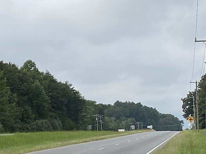
This strip of woods was not visible from the Federal position on May 9. Here’s what the view from that spot looks like today:
Burnside’s men hunkered down. “I immediately extended the right so as to secure the bank of the river and build breast-works,” said Hartranft “During the next day [May 10] I continued strengthening the works, advancing, and re-establishing the picket line. . . .”[8]
The IX Corps stayed in place until 5:00 p.m. on May 10, when “the troops moved out of the works and advanced on a general right wheel,” Cutcheon reported.[9] This movement occurred in concert with Upton’s attack against the Mule Shoe and Warren’s attack on Laurel Hill along Brock Road to the northwest. “The reconnaissance was pushed that afternoon and evening under a pretty heavy fire close up to the enemy’s lines,” Burnside wrote, “one portion of General Potter’s division being within a quarter of a mile of Spotsylvania Court-House. The line was regulated and intrenched before morning.”[10]
The distance of the advance varied depending on the unit because the line’s right-wheel movement. “I advanced my regiment with the brigade nearly three-quarters of a mile, or near the enemy’s line,” reported the 17th Michigan’s Colonel Luce.[11] Capt. Edwin Evans of the 109th New York reported, “Skirmish line advanced about one-half mile. . . .”[12] Hartranft, in contrast,
received an order to hold on to my right, and that, as the line on the left of the road would change direction to the right, I should swing my left with it. I held on to my right, but the line on the left of the road continued its advance to the front nearly a mile. I was compelled to fill in and lengthen my line in order to keep up the connection until I had much less than a line of battle.
Men from Simon Griffin’s brigade moved forward from their reserve position to fill in the gaps that began to open in Hartranft’s line as it stretched. Finally, Hartranft said, “The troops were halted in this position, and during the night built breast-works.”
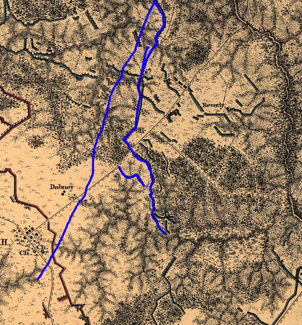
That movement, in total, looked something like this:
(If I was my colleague Edward Alexander, I would have a fancy animated map for you to show this!)
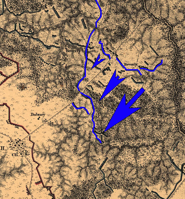
I want to take a second to underscore these accounts for a moment. If the IX Corps had been in this forward position on May 9…
…and had to launch its right-wheel advance from this position, here what that would’ve looked like…
…which would’ve resulted in a final line something like this:
But of course, Federals never made it into the village. No physical remains exist to reflect a line like this, and of course, nothing shows up on Michler’s map (made a century and a half before development rewrote any of this landscape).
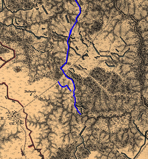
So, here’s where things stood by the evening of May 10 after the Federal advance:
The IX Corps stayed in this position until the afternoon of May 11. “On the 11th,” Burnside reported, “the entire corps was ordered to withdraw to the north side of the Ny and take a new position near the Harris house. . . . The recrossing was effected, and whilst the line was being formed in the new position, the command was ordered to recross the Ny and reoccupy the position we had just left, which was performed without any serious opposition by General Potter’s division. . . .”[13] Potter placed the withdrawal across the Ny “about dusk in a heavy storm” and the re-cross at “between 9 and 10 p.m.”[14]
If we assume John Cummings is correct in where he places Waud when Waud made his sketch (and, again, I think John is), then Waud would have been well in front of the lines if he’d made his sketch on May 9. In actuality, the earliest Waud could have gotten into a position where he was close enough to see the village to safely sketch it would have been on the evening of May 10 when the Federals had actually advanced that close.
However, as noted in part one of this series, Waud was along Upton’s front during the late-afternoon attacks of May 10. It’s likely, then, that Waud didn’t make it to the eastern front until at least May 11.
In part three of this series, we’ll trace Waud’s movements across the battlefield based on what he sketched and when and where those events took place.
————
[1] Burnside report, O.R. XXXVI, Pt. 1, 908.
[2] Willcox, O.R. XXXVI, Pt. 1, 941. Willcox wrote his first report on 13 September 1864 from the lines in front of Petersburg.
[3] Whig Hill stood on the south side of the Fredericksburg Road. A second Beverly House, “Dixie,” stood on the north side.
[4] Cutcheon, O.R. XXXVI, Pt. 1, 968, 977.
[5] Cutcheon, 968.
[6] All from O.R. XXXVI, Pt. 1: Hartranft, 948-9; Luce, 958; De Land, 973.
[7] Willcox, O.R. XXXVI, Pt. 1, 941. Willcox wrote his second report on 29 October 1864 from the Peebles’ farm outside Petersburg.
[8] Hartranft, 949.
[9] Cutcheon report, O.R. XXXVI, Pt. 1, 977.
[10] Burnside report, O.R. XXXVI, Pt. 1, 909.
[11] Luce report, O.R. XXXVI, Pt. 1, 958.
[12] Evans report, O.R. XXXVI, Pt. 1, 962.
[13] Burnside report, O.R. XXXVI, Pt. 1, 909.
[14] Potter report, O.R. XXXVI, Pt. 1, 928.
2 Responses to Alfred Waud’s Sketchy Spotsylvania (part two)