A Conversation with Cartographer Hal Jespersen
 By ECW Correspondent Jason Klaiber
In 2003, Hal Jespersen stumbled upon Michael Shaara’s novel The Killer Angels. The book, which had won the Pulitzer Prize for Fiction in 1975, tells a tale from the viewpoints of men belonging to the Union army as well as Confederates during the battle of Gettysburg in early July of 1863.
“I was captivated by it,” Jespersen says.
Jespersen had visited battlefields while in the ROTC program at Carnegie Mellon University in the late 1960s and early 1970s, but his military service during the Vietnam War curtailed his focus on anything Civil War-related, temporarily at least.
Picking up The Killer Angels later in life once again stimulated his interest. Soon after, Jespersen began immersing himself in “real” history books and visiting battlefields, starting with Adams County, Pennsylvania, where the battle of Gettysburg took place. He further educated himself by writing articles for Wikipedia concerning Civil War battles, the sites where they were fought, and the individuals involved.
Furthermore, he started working in cartography, a hobby/freelance business for which he constructs elaborate maps of these battlefields.
“As I started writing battle articles, it seemed necessary to include maps,” Jespersen said.
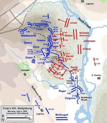
Since January 2004, Jespersen has written 285 Wikipedia articles and created more than 1200 battlefield maps, which have found additional exposure in books, magazines, websites, journals, and presentation materials. He has worked with about 80 different authors. Notably, he’s the sole cartographer to be recruited for the Emerging Civil War Series published by Savas Beatie, LLC.
“Two authors whose work I thought were noteworthy were David Mowery, whose book ‘Morgan’s Great Raid’ has the largest number of my maps, all of which are extraordinarily detailed based on his exhaustive research; and Scott Patchan, whose ‘The Last Battle of Winchester’ also has a large number of very detailed maps,” Jespersen says.
The Emerging Civil War maps, in contrast, are “high-level” maps with less detail. “They’re simpler maps intended to make it easier for the average reader to understand a complex battle,” Jespersen explains, “rather than exhaustive, detailed maps.”
Outside of the area of books, Jespersen did a series of large, full-color maps for the Franklin, Tennessee battlefield.
When Jespersen first started writing articles for Wikipedia, the database had not yet evolved much from the time of its inception in 2001. As a result, the Civil War articles were minuscule and lacked detail. He saw this as an opportunity to engage his newfound fascination with the Civil War as well as his background living in Silicon Valley, California, where he worked within the field of computer software for more than 40 years. He both expanded these short articles and wrote new ones.
“My primary focus in the early Wikipedia days was on expanding the battle of Gettysburg into a series of about eight or nine articles and sub-articles about the campaign,” Jespersen says.
With his large library of books, Jespersen never needs to leave the comfort of his home when conducting research. Jespersen says that his research is made easier by Wikipedia’s reliance on secondary sources. “A professional historian, who would normally sign his name to an encyclopedia article, can be relied upon to weigh the validity of various primary sources, using his judgment to come to the appropriate conclusions,” Jespersen explains. “However, Wikipedia is written entirely by multiple anonymous contributors, so its rules are that only secondary sources can be cited.”
“If you’re using primary sources, you don’t know how to balance one over the other,” he said.
Jespersen places an emphasis on detail when writing articles and creating maps. He asserts that a “big” battle article of his takes up to a few days to complete, while he typically spends three to four hours on the first draft of a map—not to mention an extra hour reserved for author’s corrections.
“That’s a challenge for me to actually line it up correctly,” Jespersen said. “The interesting thing about Civil War mapmaking is that you would be surprised by how inaccurate are some of the 19th century maps, such as those in the Official Records Atlas. I try to use the shape of the terrain and the exact location of current landmarks to influence how I interpret representations of 19th century roads and water courses from the historic maps.”
As sources for map data, Jespersen uses the U.S. Geological Survey (USGS) National Map; Digital Elevation Model; National Atlas; Natural Earth; Topographically Integrated Geographic Encoding and Referencing (TIGER); and Google Earth/Keyhole Markup Language (KML). By using Global Mapper, he creates the effects of shaded reliefbackground and land cover, which are “cleaned up” with Adobe Photoshop. He then transports these features, as well as historical info and AutoCAD files of state boundaries, roads, rails and rivers, into Adobe Illustrator.
Whereas other cartographers’ maps leave people guessing what the terrain looks like, Jespersen’s maps are topographically correct. He lines up each map with satellite data to ensure accuracy. He then uses shading and coloring and adds arrows and schematic terrain features—such as contour lines depicting elevation levels—to craft his intricate maps.
Despite receiving no formal training in illustration, let alone in cartography, he has managed to work his way up in the area of mapmaking, perhaps influenced by celebrated cartographers such as Jedediah Hotchkiss, who was praised for his maps of the Shenandoah Valley; George Skoch, who has published numerous maps of the Eastern Theater; and Steve Stanley, who works with the Civil War Trust.

Aside from his freelance work as a cartographer and Wikipedia contributor, Jespersen is an avid traveller. He’s visited most of the major Civil War battlefields, including Wilson’s Creek in Missouri, Antietam in Maryland, and Gettysburg, the latter of which he’s managed to visit 16 times. He claims each venture to Gettysburg is “more of a commitment than you’d think” due to the distance between Pennsylvania and his home in California.
Also, since 2005, Jespersen has been a Civil War Trust Color Bearer, supporting the preservation of Civil War battlefields. In particular, he has supported the Civil War Trust’s efforts to oppose a casino a half-mile south of Gettysburg National Military Park and a Walmart on the site of the Wilderness battlefield in Virginia.
Jespersen has also turned to different periods of time in his work. He produced a number of maps for a book about the Revolutionary War battle at Brandywine as well as some battlefield maps for the War of 1812, King Philip’s War, and Little Bighorn.
However, he has been most prolific in his work concentrating on the Civil War, of course. “About 95%” of his craft pertains to this particular conflict in American history, as he says.
“I enjoy illuminating complex battlefield actions for modern audiences in the simplest possible way,” Jespersen says. “There is also an aspect of artistic satisfaction coming up with an attractive image or illustration.”
* * *
To view a sample portfolio of Hal Jespersen’s maps as well as a collection of his maps that are available for free, visit http://www.cwmaps.com/
For a list of his contributions to Wikipedia, visit http://en.wikipedia.org/wiki/User:Hlj
Hal Jespersen’s personal website: http://www.posix.com/
Count me among those with a deep appreciation for Mr. Jespersen’s work. His maps are a perfect complement to battlefield study and truly enhance research. One’s understanding of these battles would be incomplete without them. Thank you!!
Outstanding and most grateful for the insights to this terrible war you give through your love, devotion, skill, and and cheerfulness as things unfold. Most Grateful indeed.