The Second City
The Civil War defined America – that statement is heard often in many quarters. We use that phrase in ECW’s tagline. Many effects from that conflict are quite visible in today’s America, while others are not as apparent at first glance. An example of the latter is a legacy of the Civil War that can be found on maps of the Great Lakes region of the United States – Chicago as the Second City of the USA. 
In 1860, the United States was growing and ever expanding westward. New York City was the fulcrum of the US economy, and its largest and most important city. It served also as connector on the East Coast between the interior and international destinations. However, there was a horse race among four interior cities as to which would become the Second City – the primary gateway city to the West. New Orleans, Chicago, St. Louis, and Louisville all were in the lists, although Louisville was fading. It will be noted that three of these cities were dependent on rivers; Chicago was not.
The Civil War decided the race. The war, and the closing of the Mississippi River, gave the crown to Chicago as Second City. During and after the war, Chicago was able to both maintain its economic position (the others lost ground), and leverage its access to the Great Lakes trade route and Erie Canal/St. Lawrence River to keep up commerce. It’s key location at the base of Lake Michigan also put the city astride the great westward land corridors. Chicago thus became the gateway to the West.
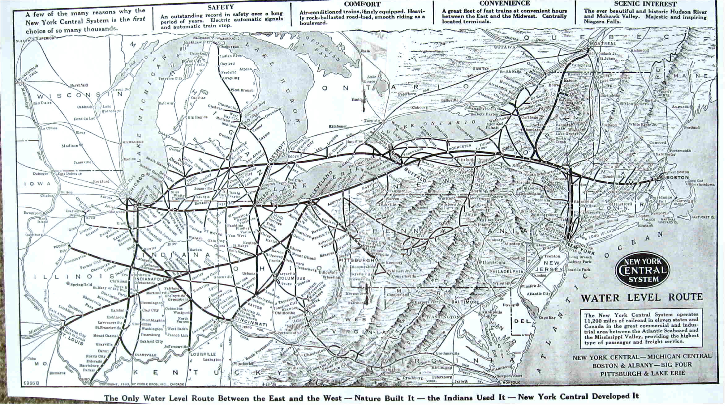
The effect of this can be seen in this 1926 map of the New York Central and the railways it connects to. Note all the ones that concentrate at Chicago, more than St. Louis.

This legacy remains visible on modern transportation maps. First, this one – a general overview of the Interstate Highway system. Six highways (55, 57, 80, 88, 90, and 94) all pass through or around Chicago. Note the three transcontinental interstates: 10, 80, 90 – two of which pass through Chicago.

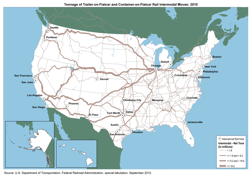
Then there’s this map of intermodal rail freight movement in 2010. Thicker lines mean more traffic on those routes. Note the concentration moving from west to east via Chicago toward New York and the Northeast.

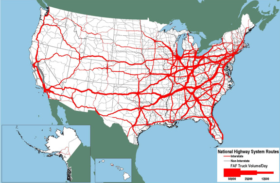
Lastly, this map of truck traffic in 2010; note how several main routes (the thickest lines) run through or near Chicago.

These maps demonstrate that Chicago remains the major east-west transportation hub in the middle of the country. Although Los Angeles is now the second-largest city in the United States, Chicago remains the primary connector between east and west. The Civil War gave the Windy City that position, one that it holds today – an enduring legacy of the Civil War.
For further reading, I recommend Nature’s Metropolis by William Cronon.
Top Image: A sign on the Ohio Turnpike (I-80/90) west of Toledo.
Of course it would have been Chicago…..the south was left to fend for itself after the war.
So many Yankee boys left home and went west–to Chicago. After 1857’s financial woes, young men were drawn to something beyond the farm or the family business, and a whole new subculture–urban employees–was born. And yes, Elmer Ellsworth was one such young man.
Actually, urbanization had been going on for a while although it really expanded throughout the 1850s. The Panic of 1857 and its aftershocks helped the process. To me, the significant thing is where many people in the East headed – not the traditional New York, Boston, Philadelphia destinations, but west to St. Louis, Milwaukee, and Chicago (or further west).
With the ban on booze and all the ways to get it into Chicago (DRIVE CANADA/US WOODS, MULTIPLE WATER CROSSINGS) AND THE LARGER THEN LIFE CHARACTERS PROHIBITION CREATED (AL CAPONE, BUGGSY SEAGAL,THE UNTOUCHABLES, ST. VALENTINE’S DAY MASSACRE) THE LARGE SLAUGHTER HOUSES THE TRAINS HAD TO TAKE TO CHICAGO TO PICK UP ICE FROM THE LAKES, I THINK CHICAGO WAS ON ITS WAY TO BECOMING 2ND CITY BROTHER